Enable Location

We need your location to show you interesting places around you

Discover nearby places

Find interesting locations and hidden gems around you

Precise directions

Get accurate directions and distances to places

Your location is never shared with other users. It's only used when you tap the location button.

Landis School

Log in to your account

Start exploring — it's free

Trusted by 62,304 travelers worldwide

Continue with Google
Continue with Apple
or

We will send you a code to connect

By continuing, you accept our Terms and Conditions and our Privacy Policy

Check your inbox

We've sent a pincode in your inbox. Please enter the code below.

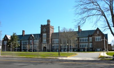
Landis School, high school in New Jersey, United States

Landis School is a school building located in Cumberland County in Vineland, New Jersey, constructed in 1927 and opened in 1928 as Vineland High School. The structure was designed by architect James Oscar Betelle in Late Gothic Revival style and sits on approximately four acres with distinctive brick and stone exterior walls.

The school opened in 1928 as Vineland High School and served the growing town as its main high school. In the 1960s and 1970s, new high schools were built nearby, which led to this building being converted to a middle school for grades 7 and 8 until 2017.

The building served as a gathering place for students and teachers for many generations in Vineland. Its role shows how schools functioned as community centers and reflected the town's commitment to education.

The building is located on West Landis Avenue in Vineland and is easy to spot from outside thanks to its tall windows and detailed stonework. It was added to the National Register of Historic Places in 1995, which helps protect its structure and makes it accessible for visitors interested in local architectural history.

The structure displays Late Gothic Revival features with tall pointed arches and detailed stonework created by architect James Oscar Betelle, who specialized in school buildings. This architectural style stands out in the neighborhood and has remained well-preserved over the decades despite changing uses.

The community of curious travelers

AroundUs brings together thousands of curated places, local tips, and hidden gems, enriched daily by 60,000 contributors worldwide.

Start exploring
Location
Inception
1928
GPS coordinates
39.48610,-75.03810
Latest update
February 9, 2026 08:20
Around this place
Palace of Depression
United States of America

Palace of Depression

2 km
St. Padre Pio Shrine
United States of America

St. Padre Pio Shrine

9.4 km
Parvin State Park
United States of America

Parvin State Park

8.6 km
Holy Virgin Protection Orthodox Church, Buena
United States of America

Holy Virgin Protection Orthodox Church, Buena

13.4 km
St. Paul's by-the-sea Protestant Episcopal Church
United States of America

St. Paul's by-the-sea Protestant Episcopal Church

17.3 km
Caesar Hoskins Log Cabin
United States of America

Caesar Hoskins Log Cabin

22.8 km
Bridgeton Historic District
United States of America

Bridgeton Historic District

17.9 km
Trinity African Methodist Episcopal Church
United States of America

Trinity African Methodist Episcopal Church

14.6 km
David V. Smith House
United States of America

David V. Smith House

16.4 km
Deerfield Presbyterian Church
United States of America

Deerfield Presbyterian Church

17.4 km
Seabrook Buddhist Temple
United States of America

Seabrook Buddhist Temple

15.9 km
David Compton House
United States of America

David Compton House

22.6 km
Beth Hillel Synagogue
United States of America

Beth Hillel Synagogue

9.5 km
Millville's First Bank Building
United States of America

Millville's First Bank Building

10.1 km
Landis Theatre
United States of America

Landis Theatre

1.8 km
Jacobus Evangelical Lutheran Church
United States of America

Jacobus Evangelical Lutheran Church

21.2 km
Free Library and Reading Room-Williamstown Memorial Library
United States of America

Free Library and Reading Room-Williamstown Memorial Library

22.2 km
Potter's Tavern
United States of America

Potter's Tavern

18.4 km
Hall Street School
United States of America

Hall Street School

22.6 km
Captain Isaac Peterson House
United States of America

Captain Isaac Peterson House

22.6 km
Abraham and Ann Hoy House
United States of America

Abraham and Ann Hoy House

22.8 km
Jeremiah Buck House
United States of America

Jeremiah Buck House

17.4 km
Gen. James Giles House
United States of America

Gen. James Giles House

18.7 km
Samuel W. Seeley House
United States of America

Samuel W. Seeley House

17.5 km
Wood Mansion House
United States of America

Wood Mansion House

9.3 km
Philip Fries House
United States of America

Philip Fries House

22.6 km
Levoy Theatre
United States of America

Levoy Theatre

9.9 km
Mauricetown Historic District
United States of America

Mauricetown Historic District

22.6 km
Show the full map
« Landis School - high school in New Jersey, United States » is provided by Around Us (aroundus.com). Images and texts are derived from Wikimedia project under a Creative Commons license. You are allowed to copy, distribute, and modify copies of this page, under the conditions set by the license, as long as this note is clearly visible.

Discover hidden gems everywhere you go!

From secret cafés to breathtaking viewpoints, skip the crowded tourist spots and find places that match your style. Our app makes it easy with voice search, smart filtering, route optimization, and insider tips from travelers worldwide. Download now for the complete mobile experience.

Around Us App Screenshot

A unique approach to discovering new places

Le Figaro

All the places worth exploring

France Info

A tailor-made excursion in just a few clicks

20 Minutes

Around Us
Travel Guide & Maps
Download

Send to your phone

QR Code
1

Open the camera app on your mobile.

2

Point at the QR code with your camera. A notification will appear.

3

Tap the notification to open the link.