Enable Location

We need your location to show you interesting places around you

Discover nearby places

Find interesting locations and hidden gems around you

Precise directions

Get accurate directions and distances to places

Your location is never shared with other users. It's only used when you tap the location button.

Log in to your account

Start exploring — it's free

Trusted by 62,043 travelers worldwide

Continue with Google
Continue with Apple
or

We will send you a code to connect

By continuing, you accept our Terms and Conditions and our Privacy Policy

Check your inbox

We've sent a pincode in your inbox. Please enter the code below.

Mid-Currituck Bridge

Mid-Currituck Bridge, Toll bridge project in Currituck County, United States.

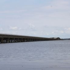
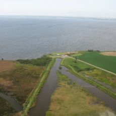
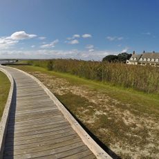
The Mid-Currituck Bridge is a toll bridge in North Carolina that spans Currituck Sound to connect the mainland with the Outer Banks. The structure includes two separate sections: one crossing the sound and another running through Maple Swamp to reach U.S. Route 158.

Transportation planners first proposed crossing Currituck Sound in the 1970s, with various agencies studying the feasibility over several decades. The North Carolina Turnpike Authority formally adopted the project in 2008 to move forward with construction.

The bridge represents a critical infrastructure development that will transform access to the coastal communities of North Carolina's Outer Banks region.

Access to the bridge is available through U.S. Route 158 and existing mainland road networks. Visitors should be aware that this is a toll facility and fees will apply to cross.

The project combines two distinct bridge segments with different engineering challenges: one spanning open water and the other crossing wetland terrain. This combination required careful planning to address the unique conditions of each section.

The community of curious travelers

AroundUs brings together thousands of curated places, local tips, and hidden gems, enriched daily by 60,000 contributors worldwide.

Start exploring
Location
GPS coordinates
36.33280,-75.90790
Latest update
December 11, 2025 11:07
Around this place
Currituck Beach Lighthouse
United States of America

Currituck Beach Lighthouse

8.5 km
Currituck Beach Lighthouse
United States of America

Currituck Beach Lighthouse

8.5 km
False Cape State Park
United States of America

False Cape State Park

28.5 km
Whalehead Club
United States of America

Whalehead Club

8.1 km
Wright Memorial Bridge
United States of America

Wright Memorial Bridge

30.3 km
Currituck National Wildlife Refuge
United States of America

Currituck National Wildlife Refuge

21.9 km
Mackay Island National Wildlife Refuge
United States of America

Mackay Island National Wildlife Refuge

19 km
H2OBX Waterpark
United States of America

H2OBX Waterpark

25.7 km
Jarvisburg Colored School
United States of America

Jarvisburg Colored School

16.7 km
False Cape Natural Area Preserve
United States of America

False Cape Natural Area Preserve

31.6 km
Old Brick House
United States of America

Old Brick House

28.1 km
Elizabeth City Historic District
United States of America

Elizabeth City Historic District

28.5 km
Coinjock Colored School
United States of America

Coinjock Colored School

6.2 km
Camden County Jail
United States of America

Camden County Jail

24 km
Twin Houses
United States of America

Twin Houses

19 km
Milford
United States of America

Milford

27.8 km
Currituck County Courthouse and Jail
United States of America

Currituck County Courthouse and Jail

16.3 km
Murfreesboro Historic District
United States of America

Murfreesboro Historic District

21.2 km
Culong
United States of America

Culong

15.4 km
Shaw House
United States of America

Shaw House

18.5 km
Camden County Courthouse
United States of America

Camden County Courthouse

23.7 km
Northside Historic District
United States of America

Northside Historic District

28.2 km
Episcopal Cemetery
United States of America

Episcopal Cemetery

28.3 km
Whalehead in Historic Corolla
United States of America

Whalehead in Historic Corolla

8.1 km
Riverside Historic District
United States of America

Riverside Historic District

27.4 km
Elizabeth City Water Plant
United States of America

Elizabeth City Water Plant

28.6 km
Caleb Grandy House
United States of America

Caleb Grandy House

23.4 km
Grandy School
United States of America

Grandy School

10.3 km
Show the full map
« Mid-Currituck Bridge - Toll bridge project in Currituck County, United States » is provided by Around Us (aroundus.com). Images and texts are derived from Wikimedia project under a Creative Commons license. You are allowed to copy, distribute, and modify copies of this page, under the conditions set by the license, as long as this note is clearly visible.

Discover hidden gems everywhere you go!

From secret cafés to breathtaking viewpoints, skip the crowded tourist spots and find places that match your style. Our app makes it easy with voice search, smart filtering, route optimization, and insider tips from travelers worldwide. Download now for the complete mobile experience.

Around Us App Screenshot

A unique approach to discovering new places

Le Figaro

All the places worth exploring

France Info

A tailor-made excursion in just a few clicks

20 Minutes

Around Us
Travel Guide & Maps
Download

Send to your phone

QR Code
1

Open the camera app on your mobile.

2

Point at the QR code with your camera. A notification will appear.

3

Tap the notification to open the link.