Enable Location

We need your location to show you interesting places around you

Discover nearby places

Find interesting locations and hidden gems around you

Precise directions

Get accurate directions and distances to places

Your location is never shared with other users. It's only used when you tap the location button.

National Cemetery of the Alleghenies

Log in to your account

Start exploring — it's free

Trusted by 62,268 travelers worldwide

Continue with Google
Continue with Apple
or

We will send you a code to connect

By continuing, you accept our Terms and Conditions and our Privacy Policy

Check your inbox

We've sent a pincode in your inbox. Please enter the code below.

National Cemetery of the Alleghenies

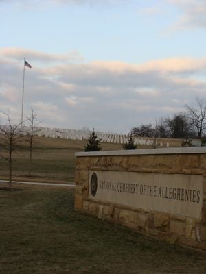
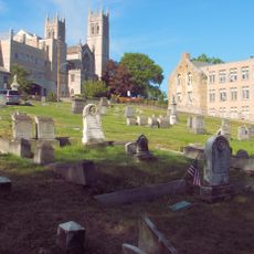
National Cemetery of the Alleghenies, Military cemetery in Cecil Township, United States.

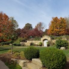
The National Cemetery of the Alleghenies sits across 292 acres in Washington County, Pennsylvania, about 20 miles (32 km) southwest of Pittsburgh. The grounds feature rows of graves, monuments, and a maintained memorial pathway.

The grounds were established in 2005 and preserve an older cemetery with graves from the late 1700s, dating to the Whisky Rebellion era. These earlier burials show the long settlement history of the region.

The Memorial Pathway honors different military branches through dedicated monuments, including recognition of the Tuskegee Airmen who served in World War II. These tributes show how the grounds celebrate the diversity and courage of those who served.

The grounds are open daily from sunrise to sunset with clear pathways through the graves and monuments. It is best to explore on foot and wear comfortable shoes for walking across the open terrain.

The cemetery maintains over 27,000 memorial records with a 95 percent photographic documentation rate thanks to volunteer efforts. This extensive photography helps visitors locate and document burial sites.

The community of curious travelers

AroundUs brings together thousands of curated places, local tips, and hidden gems, enriched daily by 60,000 contributors worldwide.

Start exploring
Location
Inception
2005
GPS coordinates
40.31667,-80.15417
Latest update
December 9, 2025 18:47
Around this place
Montour Trail
United States of America

Montour Trail

6.3 km
Pennsylvania Trolley Museum
United States of America

Pennsylvania Trolley Museum

14.8 km
Oliver Miller Homestead
United States of America

Oliver Miller Homestead

12.5 km
South Park
United States of America

South Park

12.5 km
Woodville
United States of America

Woodville

8.6 km
Pittsburgh Botanic Garden
United States of America

Pittsburgh Botanic Garden

10.8 km
Black Horse Tavern
United States of America

Black Horse Tavern

8 km
Roberts House
United States of America

Roberts House

6.8 km
Linden Grove
United States of America

Linden Grove

13.2 km
Fulton Log House
United States of America

Fulton Log House

7.3 km
Walker-Ewing Log House
United States of America

Walker-Ewing Log House

10.5 km
Andrew Carnegie Free Library
United States of America

Andrew Carnegie Free Library

11.6 km
Denis Theatre
United States of America

Denis Theatre

11.8 km
Walker-Ewing-Glass Log House
United States of America

Walker-Ewing-Glass Log House

11.4 km
Pittsburgh Botanical Garden Welcome Center
United States of America

Pittsburgh Botanical Garden Welcome Center

11.3 km
Enoch Wright House
United States of America

Enoch Wright House

13 km
Samuel Brownlee House
United States of America

Samuel Brownlee House

12.4 km
James Thome Farm
United States of America

James Thome Farm

13.2 km
Oakdale Public School
United States of America

Oakdale Public School

9.4 km
Thomas Munce House
United States of America

Thomas Munce House

14.6 km
First Church of Christ, Scientist
United States of America

First Church of Christ, Scientist

10.6 km
Pennsylvania Trolley Museum
United States of America

Pennsylvania Trolley Museum

14.1 km
Thornburg Historic District
United States of America

Thornburg Historic District

14.2 km
Stephenson-Campbell House
United States of America

Stephenson-Campbell House

4.5 km
St. Clair Cemetery
United States of America

St. Clair Cemetery

12.4 km
Mt. Lebanon Public Library
United States of America

Mt. Lebanon Public Library

11.4 km
John McMillan's Log School
United States of America

John McMillan's Log School

6.8 km
Dormont Public Library
United States of America

Dormont Public Library

13.3 km
Show the full map
« National Cemetery of the Alleghenies - Military cemetery in Cecil Township, United States » is provided by Around Us (aroundus.com). Images and texts are derived from Wikimedia project under a Creative Commons license. You are allowed to copy, distribute, and modify copies of this page, under the conditions set by the license, as long as this note is clearly visible.

Discover hidden gems everywhere you go!

From secret cafés to breathtaking viewpoints, skip the crowded tourist spots and find places that match your style. Our app makes it easy with voice search, smart filtering, route optimization, and insider tips from travelers worldwide. Download now for the complete mobile experience.

Around Us App Screenshot

A unique approach to discovering new places

Le Figaro

All the places worth exploring

France Info

A tailor-made excursion in just a few clicks

20 Minutes

Around Us
Travel Guide & Maps
Download

Send to your phone

QR Code
1

Open the camera app on your mobile.

2

Point at the QR code with your camera. A notification will appear.

3

Tap the notification to open the link.