Enable Location

We need your location to show you interesting places around you

Discover nearby places

Find interesting locations and hidden gems around you

Precise directions

Get accurate directions and distances to places

Your location is never shared with other users. It's only used when you tap the location button.

San Domingo School

Log in to your account

Start exploring — it's free

Trusted by 62,392 travelers worldwide

Continue with Google
Continue with Apple
or

We will send you a code to connect

By continuing, you accept our Terms and Conditions and our Privacy Policy

Check your inbox

We've sent a pincode in your inbox. Please enter the code below.

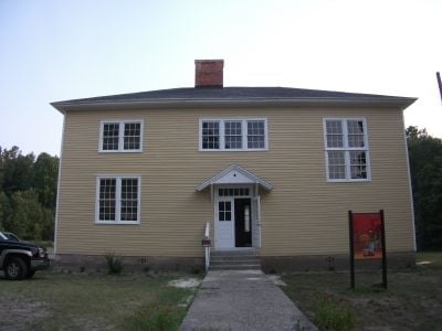
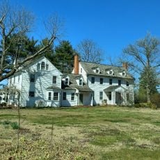
San Domingo School, historic school building located in Maryland, USA

San Domingo School is a wooden school building with two stories and a hipped roof, constructed in 1919 on just over an acre of land. It features large windows, wood floors, and a simple rectangular design typical of early 20th-century American school architecture.

Built in 1919 as a school for Black children, it operated until 1957 with only four teachers serving the community. It is one of the few surviving Rosenwald schools in the area, funded partly by Julius Rosenwald's initiative to improve education for Black children when state support was often lacking.

The name San Domingo may reference the Caribbean island where a major slave revolt occurred, though its exact origin remains uncertain. The building stands today as a symbol of the independence and community spirit that defined the historical settlement.

The building is easily accessible and displays its original construction with preserved windows and wood floors visible during visits. It is best to arrive in the morning or early afternoon when sunlight through the large windows illuminates the interior most effectively.

The school is also known as Sharptown Colored School and Prince Hall Masons Unity Lodge No. 73, names reflecting its transformation from a school into a gathering place for a Masonic lodge. This dual purpose shows how the building adapted to community needs and remained a meeting space for local organizations.

The community of curious travelers

AroundUs brings together thousands of curated places, local tips, and hidden gems, enriched daily by 60,000 contributors worldwide.

Start exploring
Location
GPS coordinates
38.51080,-75.72280
Latest update
February 9, 2026 08:18
Around this place
Highball Signal
United States of America

Highball Signal

14 km
Woodland Ferry
United States of America

Woodland Ferry

11.5 km
Pemberton Hall
United States of America

Pemberton Hall

19.6 km
Poplar Hill Mansion
United States of America

Poplar Hill Mansion

19.1 km
Gov. William H. Ross House
United States of America

Gov. William H. Ross House

18.5 km
Old Christ Church
United States of America

Old Christ Church

17.1 km
Handsell
United States of America

Handsell

7.8 km
Gillis-Grier House
United States of America

Gillis-Grier House

19 km
Sen. William P. Jackson House
United States of America

Sen. William P. Jackson House

19.6 km
Maude R. Toulson Federal Building
United States of America

Maude R. Toulson Federal Building

19.4 km
Rehoboth
United States of America

Rehoboth

10.7 km
Spring Hill Church
United States of America

Spring Hill Church

10 km
Perry-Cooper House
United States of America

Perry-Cooper House

19.2 km
Bethel Historic District
United States of America

Bethel Historic District

10.8 km
Edgar and Rachel Ross House
United States of America

Edgar and Rachel Ross House

17.7 km
F. Leonard Wailes Law Office
United States of America

F. Leonard Wailes Law Office

19.4 km
Spring Garden
United States of America

Spring Garden

14.8 km
Sussex National Bank of Seaford
United States of America

Sussex National Bank of Seaford

17.3 km
Dickerson Potato House
United States of America

Dickerson Potato House

6.1 km
Stanley Potato House
United States of America

Stanley Potato House

15.7 km
St. Giles
United States of America

St. Giles

11 km
J. W. Cox Dry Goods Store
United States of America

J. W. Cox Dry Goods Store

17.4 km
Rider Potato House
United States of America

Rider Potato House

17.1 km
First National Bank of Seaford
United States of America

First National Bank of Seaford

17.5 km
Phillips Potato House
United States of America

Phillips Potato House

10.5 km
Building at 200–202A High Street
United States of America

Building at 200–202A High Street

17.3 km
Bryan's Bowling Center
United States of America

Bryan's Bowling Center

14.1 km
Laurel Historic District
United States of America

Laurel Historic District

14.1 km
Show the full map
« San Domingo School - historic school building located in Maryland, USA » is provided by Around Us (aroundus.com). Images and texts are derived from Wikimedia project under a Creative Commons license. You are allowed to copy, distribute, and modify copies of this page, under the conditions set by the license, as long as this note is clearly visible.

Discover hidden gems everywhere you go!

From secret cafés to breathtaking viewpoints, skip the crowded tourist spots and find places that match your style. Our app makes it easy with voice search, smart filtering, route optimization, and insider tips from travelers worldwide. Download now for the complete mobile experience.

Around Us App Screenshot

A unique approach to discovering new places

Le Figaro

All the places worth exploring

France Info

A tailor-made excursion in just a few clicks

20 Minutes

Around Us
Travel Guide & Maps
Download

Send to your phone

QR Code
1

Open the camera app on your mobile.

2

Point at the QR code with your camera. A notification will appear.

3

Tap the notification to open the link.