St. Joseph's House for Homeless Industrious Boys

Log in to your account

AroundUs is a community-driven map of interesting places, built by curious explorers like you. It grows with every review, story, and photo you share.
Connect to save your favorite spots, contribute locations, and create personalized routes.
Continue with Google
Continue with Apple
Continue with X
Continue with Facebook
Continue with email
By continuing, you accept our Terms and Conditions and our Privacy Policy
Create an account
Add to collection
Map
Suggest a change
Share

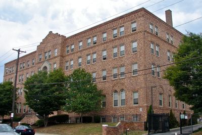
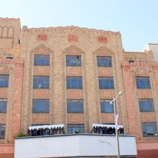
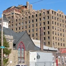
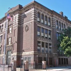
St. Joseph's House for Homeless Industrious Boys, Social service building in Nicetown-Tioga, Philadelphia, United States.

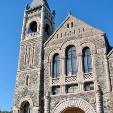
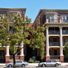
St. Joseph's House is a social service building in Nicetown-Tioga with Renaissance Revival design that blends Romanesque, Italianate, and Tudor Revival details across its facade. The structure stretches along West Allegheny Avenue and presents a mix of architectural traditions in its exterior composition.

The building was designed and constructed in 1929 by Philadelphia's architectural firm Hoffman-Henon. It earned National Register of Historic Places recognition in 1996, securing its status as a protected landmark.

This facility served homeless young men in Philadelphia by providing them with shelter and teaching them practical work skills. The place represented a community effort to give youth a path toward independence and self-sufficiency.

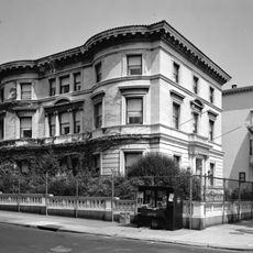
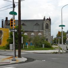
The building is located in the Nicetown-Tioga neighborhood, nestled within a residential area alongside other older structures and street trees. It stands out visually from many surrounding properties because of its distinctive architectural style.

The building blends multiple architectural styles into one facade, making it an interesting example of the eclectic taste of the 1920s era. This unusual combination of Romanesque, Italianate, and Tudor Revival often surprises visitors who examine the details closely.

Location: Philadelphia

Architects: Hoffman-Henon

Architectural style: Renaissance Revival architecture

GPS coordinates: 40.00167,-75.15611

Latest update: December 14, 2025 16:44

Photos
Around this place
Baker Bowl
United States of America

Baker Bowl

959 m
Laurel Hill Cemetery
United States of America

Laurel Hill Cemetery

2.7 km
Liacouras Center
United States of America

Liacouras Center

2.4 km
Uptown Theatre
United States of America

Uptown Theatre

1.6 km
Germantown Cricket Club
United States of America

Germantown Cricket Club

2.9 km
Stenton
United States of America

Stenton

2.5 km
Wagner Free Institute of Science
United States of America

Wagner Free Institute of Science

2.4 km
McGonigle Hall
United States of America

McGonigle Hall

2.3 km
Joe Frazier's Gym
United States of America

Joe Frazier's Gym

532 m
The Medicine Man
United States of America

The Medicine Man

2.8 km
United States of America

Odd Fellows Cemetery

2.2 km
Church of the Advocate
United States of America

Church of the Advocate

1.9 km
Chamounix
United States of America

Chamounix

2.5 km
Loudoun Mansion
United States of America

Loudoun Mansion

2.7 km
Most Precious Blood Roman Catholic Church, Rectory and Parochial School
United States of America

Most Precious Blood Roman Catholic Church, Rectory and Parochial School

2.6 km
Philly Mosque
United States of America

Philly Mosque

566 m
National Bank of North Philadelphia
United States of America

National Bank of North Philadelphia

1 km
John Greenleaf Whittier School
United States of America

John Greenleaf Whittier School

1.5 km
Sally Watson House
United States of America

Sally Watson House

2.9 km
Henry O. Tanner House
United States of America

Henry O. Tanner House

2.7 km
Dobson Mills
United States of America

Dobson Mills

2.7 km
Union Methodist Episcopal Church
United States of America

Union Methodist Episcopal Church

2 km
North Broad Street Mansion District
United States of America

North Broad Street Mansion District

2.8 km
Northern National Bank
United States of America

Northern National Bank

1.9 km
David Farragut School
United States of America

David Farragut School

2.3 km
McDowell Memorial Presbyterian Church
United States of America

McDowell Memorial Presbyterian Church

2.7 km
Plaza Apartments
United States of America

Plaza Apartments

2.7 km
Edward G. Budd Manufacturing Company Building
United States of America

Edward G. Budd Manufacturing Company Building

1.4 km
Show the full map
Reviews

Visited this place? Tap the stars to rate it and share your experience / photos with the community! Try now! You can cancel it anytime.

« St. Joseph's House for Homeless Industrious Boys - Social service building in Nicetown-Tioga, Philadelphia, United States » is provided by Around Us (aroundus.com). Images and texts are derived from Wikimedia project under a Creative Commons license. You are allowed to copy, distribute, and modify copies of this page, under the conditions set by the license, as long as this note is clearly visible.

Discover hidden gems everywhere you go!

From secret cafés to breathtaking viewpoints, skip the crowded tourist spots and find places that match your style. Our app makes it easy with voice search, smart filtering, route optimization, and insider tips from travelers worldwide. Download now for the complete mobile experience.

Around Us App Screenshot

A unique approach to discovering new places

Le Figaro

All the places worth exploring

France Info

A tailor-made excursion in just a few clicks

20 Minutes