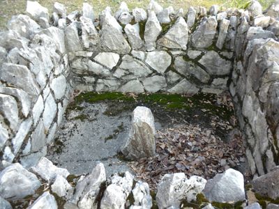
Star Gazers' Stone, Survey pillar in Embreeville, Pennsylvania, US.
Star Gazers' Stone is a limestone marker in Embreeville, Pennsylvania, set in the ground as a fixed reference point for the survey that drew the border between Pennsylvania and Maryland. The stone stands in an open outdoor setting, visible from the surrounding area without any fencing or barriers around it.
The stone was placed in 1764 when surveyors Charles Mason and Jeremiah Dixon began their work to settle a long-running territorial dispute between Pennsylvania and Maryland. Their survey took several years to complete and produced the boundary line that still carries their names today.
The Star Gazers' Stone was a working base for surveyors who looked at the night sky to fix land boundaries on paper. Standing here today, visitors can see how exposed and simple the site is, just a stone in an open field with no shelter around it.
The site is outdoors and easy to reach on foot, with a small parking area nearby for those arriving by car. There is no shelter on site, so weather-appropriate clothing is a good idea for any season.
Mason and Dixon built a temporary wooden shelter at this spot in winter to protect their sky observations, taking advantage of the long clear nights of the season for their precise measurements. The shelter was removed after the work ended, but the stone remained as a lasting marker of where they started.
The community of curious travelers
AroundUs brings together thousands of curated places, local tips, and hidden gems, enriched daily by 60,000 contributors worldwide.