Enable Location

We need your location to show you interesting places around you

Discover nearby places

Find interesting locations and hidden gems around you

Precise directions

Get accurate directions and distances to places

Your location is never shared with other users. It's only used when you tap the location button.

Starrucca Viaduct

Log in to your account

Start exploring — it's free

Trusted by 63,323 travelers worldwide

Continue with Google
Continue with Apple
or

We will send you a code to connect

By continuing, you accept our Terms and Conditions and our Privacy Policy

Check your inbox

We've sent a pincode in your inbox. Please enter the code below.

Discussion Reviews 1 Photos
9.9k Popularity

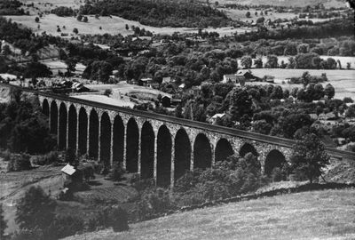
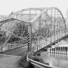
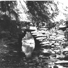
Starrucca Viaduct, Railway bridge in Lanesboro, United States.

The Starrucca Viaduct is a railway bridge made of stone that spans across Starrucca Creek with 17 arches built from local bluestone. The structure crosses the valley with a sweeping arch design that supports active rail traffic.

The bridge was built between 1847 and 1848 for the New York and Erie Railroad and demonstrated early applications of advanced construction methods. It was a significant project that modernized railway infrastructure in the region.

The viaduct stands as a testament to nineteenth-century engineering, earning recognition on the National Register of Historic Places and as a National Civil Engineering Landmark.

You can view the bridge from Luciana Park on Depot Street and get clear views of the stone arch construction there. The park offers a suitable spot to observe the structure and the valley below.

The structure continues its original function after 175 years, carrying two standard gauge tracks while maintaining its original stone architecture and design elements.

The community of curious travelers

AroundUs brings together thousands of curated places, local tips, and hidden gems, enriched daily by 60,000 contributors worldwide.

Start exploring
Location
Inception
1848
Official opening
1848
Height
30.5 m
Length
317 m
Made from material
stone
GPS coordinates
41.96280,-75.58340
Latest update
December 8, 2025 19:53
Around this place
New York State Inebriate Asylum
United States of America

New York State Inebriate Asylum

28.3 km
Salt Springs State Park
United States of America

Salt Springs State Park

24.1 km
Cannonsville Reservoir
United States of America

Cannonsville Reservoir

25.6 km
Phelps Mansion
United States of America

Phelps Mansion

30.8 km
Oquaga Creek State Park
United States of America

Oquaga Creek State Park

27.1 km
Mount Ararat
United States of America

Mount Ararat

21.8 km
South Washington Street Parabolic Bridge
United States of America

South Washington Street Parabolic Bridge

31 km
Court Street Historic District
United States of America

Court Street Historic District

31.1 km
Railroad Terminal Historic District
United States of America

Railroad Terminal Historic District

31.1 km
Broome County Courthouse
United States of America

Broome County Courthouse

31 km
Binghamton City Hall
United States of America

Binghamton City Hall

31.1 km
Ross Park Carousel
United States of America

Ross Park Carousel

29.6 km
Ouaquaga Lenticular Truss Bridge
United States of America

Ouaquaga Lenticular Truss Bridge

18.6 km
Cutler Botanic Garden
United States of America

Cutler Botanic Garden

31.3 km
Susquehanna County Courthouse Complex
United States of America

Susquehanna County Courthouse Complex

28.2 km
Alfred Dunk House
United States of America

Alfred Dunk House

30.9 km
Montrose Historic District
United States of America

Montrose Historic District

28.3 km
Conklin Town Hall
United States of America

Conklin Town Hall

20.8 km
Silver Lake Bank
United States of America

Silver Lake Bank

28.3 km
Sylvanus Mulford House
United States of America

Sylvanus Mulford House

28.3 km
Harpursville United Methodist Church
United States of America

Harpursville United Methodist Church

24.2 km
Bridge in Gibson Borough
United States of America

Bridge in Gibson Borough

24.9 km
Trinity Memorial Church
United States of America

Trinity Memorial Church

29.1 km
Old Hawleyton Methodist Episcopal Church
United States of America

Old Hawleyton Methodist Episcopal Church

28.3 km
State Street-Henry Street Historic District
United States of America

State Street-Henry Street Historic District

31.3 km
Main Street Historic District
United States of America

Main Street Historic District

29.9 km
Windsor Village Historic District
United States of America

Windsor Village Historic District

13.7 km
Holden B. Mathewson House
United States of America

Holden B. Mathewson House

29.9 km
Show the full map
Reviews
Share your experience

No review yet

Discussions
Start a discussion...

No discussion yet

« Starrucca Viaduct - Railway bridge in Lanesboro, United States » is provided by Around Us (aroundus.com). Images and texts are derived from Wikimedia project under a Creative Commons license. You are allowed to copy, distribute, and modify copies of this page, under the conditions set by the license, as long as this note is clearly visible.

Discover hidden gems everywhere you go!

From secret cafés to breathtaking viewpoints, skip the crowded tourist spots and find places that match your style. Our app makes it easy with voice search, smart filtering, route optimization, and insider tips from travelers worldwide. Download now for the complete mobile experience.

Around Us App Screenshot

A unique approach to discovering new places

Le Figaro

All the places worth exploring

France Info

A tailor-made excursion in just a few clicks

20 Minutes

Around Us
Travel Guide & Maps
Download

Send to your phone

QR Code
1

Open the camera app on your mobile.

2

Point at the QR code with your camera. A notification will appear.

3

Tap the notification to open the link.