Enable Location

We need your location to show you interesting places around you

Discover nearby places

Find interesting locations and hidden gems around you

Precise directions

Get accurate directions and distances to places

Your location is never shared with other users. It's only used when you tap the location button.

Stallings Air Base

Log in to your account

Start exploring — it's free

Trusted by 62,043 travelers worldwide

Continue with Google
Continue with Apple
or

We will send you a code to connect

By continuing, you accept our Terms and Conditions and our Privacy Policy

Check your inbox

We've sent a pincode in your inbox. Please enter the code below.

Stallings Air Base

Stallings Air Base, Military air base in Kinston, North Carolina, United States

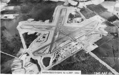
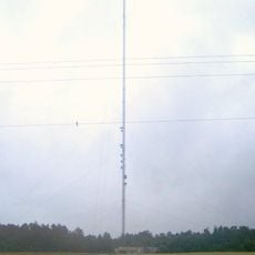
Stallings Air Base is a military aviation facility near Kinston, North Carolina, with three concrete runways, multiple aircraft hangars, taxiways, a large parking apron, and a control tower. The infrastructure supports sustained flight operations with dedicated handling areas and facilities for air traffic control.

The facility was constructed by the U.S. Navy in 1944 and initially opened as a Marine Corps auxiliary airfield before becoming an Air Force installation. This transition reflected the military's changing operational needs after the war.

The airfield carries the names of two fallen officers from Kinston, Lieutenants Bruce and Harry Stallings, who died during World War II. The installation serves as a local memorial to their service.

The site is most accessible during operating hours and may require advance permission for visits. Contacting the facility administration or visitor center beforehand helps arrange tours or site access.

After military operations ended, the facility was transformed into Kinston Regional Jetport and continues to serve civilian aviation. This conversion demonstrates how Cold War military infrastructure found new purpose in the civil sector.

The community of curious travelers

AroundUs brings together thousands of curated places, local tips, and hidden gems, enriched daily by 60,000 contributors worldwide.

Start exploring
Location
Inception
1944
GPS coordinates
35.33140,-77.60890
Latest update
December 13, 2025 11:42
Around this place
Cliffs of the Neuse State Park
United States of America

Cliffs of the Neuse State Park

27.1 km
Fort Neoheroka
United States of America

Fort Neoheroka

19.7 km
Harmony Hall
United States of America

Harmony Hall

8.4 km
William H. Long House
United States of America

William H. Long House

24.7 km
Dempsey Wood House
United States of America

Dempsey Wood House

15.4 km
Temple Israel
United States of America

Temple Israel

6.9 km
La Grange Presbyterian Church
United States of America

La Grange Presbyterian Church

16.6 km
American Tobacco Company Prizery
United States of America

American Tobacco Company Prizery

7.3 km
Kinston Baptist-White Rock Presbyterian Church
United States of America

Kinston Baptist-White Rock Presbyterian Church

8.1 km
La Grange Historic District (North Carolina)
United States of America

La Grange Historic District (North Carolina)

16.9 km
Neuseway Nature Center and Planetarium
United States of America

Neuseway Nature Center and Planetarium

8.2 km
Lenoir County Courthouse
United States of America

Lenoir County Courthouse

8.7 km
Mitchelltown Historic District
United States of America

Mitchelltown Historic District

7.5 km
B. W. Canady House
United States of America

B. W. Canady House

7.6 km
Robert L. Blalock House
United States of America

Robert L. Blalock House

8.7 km
Baptist Parsonage
United States of America

Baptist Parsonage

8.6 km
Hill–Grainger Historic District
United States of America

Hill–Grainger Historic District

7.2 km
Cox-Ange House
United States of America

Cox-Ange House

28.9 km
Sumrell and McCoy Building
United States of America

Sumrell and McCoy Building

7.9 km
St. John's Episcopal Church
United States of America

St. John's Episcopal Church

23.1 km
Kennedy Memorial Home Historic District
United States of America

Kennedy Memorial Home Historic District

11.4 km
Greene County Courthouse
United States of America

Greene County Courthouse

14.9 km
Cedar Dell
United States of America

Cedar Dell

11.2 km
Carter-Simmons House
United States of America

Carter-Simmons House

31.5 km
Queen-Gordon Streets Historic District
United States of America

Queen-Gordon Streets Historic District

8.1 km
WITN-Tower
United States of America

WITN-Tower

19.9 km
CSS Neuse Museum
United States of America

CSS Neuse Museum

8.3 km
CSS Neuse II
United States of America

CSS Neuse II

8.1 km
Show the full map
« Stallings Air Base - Military air base in Kinston, North Carolina, United States » is provided by Around Us (aroundus.com). Images and texts are derived from Wikimedia project under a Creative Commons license. You are allowed to copy, distribute, and modify copies of this page, under the conditions set by the license, as long as this note is clearly visible.

Discover hidden gems everywhere you go!

From secret cafés to breathtaking viewpoints, skip the crowded tourist spots and find places that match your style. Our app makes it easy with voice search, smart filtering, route optimization, and insider tips from travelers worldwide. Download now for the complete mobile experience.

Around Us App Screenshot

A unique approach to discovering new places

Le Figaro

All the places worth exploring

France Info

A tailor-made excursion in just a few clicks

20 Minutes

Around Us
Travel Guide & Maps
Download

Send to your phone

QR Code
1

Open the camera app on your mobile.

2

Point at the QR code with your camera. A notification will appear.

3

Tap the notification to open the link.