Enable Location

We need your location to show you interesting places around you

Discover nearby places

Find interesting locations and hidden gems around you

Precise directions

Get accurate directions and distances to places

Your location is never shared with other users. It's only used when you tap the location button.

Wells State Park

Log in to your account

Start exploring — it's free

Trusted by 62,492 travelers worldwide

Continue with Google
Continue with Apple
or

We will send you a code to connect

By continuing, you accept our Terms and Conditions and our Privacy Policy

Check your inbox

We've sent a pincode in your inbox. Please enter the code below.

Wells State Park

Wells State Park, State park in Sturbridge, United States.

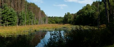
Wells State Park is a protected natural area in Sturbridge covering wooded and wetland terrain with Walker Pond at its center. The property includes campsites, swimming areas, and trail networks that support year-round outdoor recreation.

The state park was established in 1968 to protect natural resources and serve local communities seeking outdoor recreation. This designation began a period of managed conservation for the forested landscape and its wildlife habitats.

The park's interpretive program introduces visitors to local ecosystems through guided walks, educational hikes, and evening gatherings around campfires during summer months.

Visitors can camp, hike, swim, or use boat ramps throughout the year with facilities distributed across the property. Spring through fall offers the most comfortable conditions for swimming and hiking, while winter brings quieter exploration opportunities.

Carpenter Rocks offers elevated viewpoints across Walker Pond and the park's eastern sections from rocky outcrops accessible by trail. This rock formation draws visitors seeking different perspectives of the landscape beyond typical waterside views.

The community of curious travelers

AroundUs brings together thousands of curated places, local tips, and hidden gems, enriched daily by 60,000 contributors worldwide.

Start exploring
Location
Inception
1968
GPS coordinates
42.14640,-72.06690
Latest update
December 12, 2025 07:58
Around this place
Old Sturbridge Village
United States of America

Old Sturbridge Village

4.9 km
Oliver Wight House
United States of America

Oliver Wight House

4.3 km
Evangelical Free Church
United States of America

Evangelical Free Church

7.5 km
Building at 29–31 River Street
United States of America

Building at 29–31 River Street

7.5 km
Alexis Boyer House
United States of America

Alexis Boyer House

7.6 km
Sturbridge Common Historic District
United States of America

Sturbridge Common Historic District

4.5 km
Hamilton Woolen Company Historic District
United States of America

Hamilton Woolen Company Historic District

7.4 km
James Gleason Cottage
United States of America

James Gleason Cottage

7.7 km
A. Kinney House
United States of America

A. Kinney House

7.9 km
Cliff Cottage
United States of America

Cliff Cottage

7.3 km
Hamilton Mill-West Street Factory Housing
United States of America

Hamilton Mill-West Street Factory Housing

7.6 km
Dani and Soldani Cabinet Makers and Wood Workers Factory
United States of America

Dani and Soldani Cabinet Makers and Wood Workers Factory

7.2 km
Judson–Litchfield House
United States of America

Judson–Litchfield House

7.9 km
J.M. Cheney Rental House
United States of America

J.M. Cheney Rental House

7.9 km
William McKinstry Farmhouse
United States of America

William McKinstry Farmhouse

6.5 km
Mrs. R. Marcy House
United States of America

Mrs. R. Marcy House

8 km
Academie Brochu
United States of America

Academie Brochu

7.8 km
Building at 25–27 River Street
United States of America

Building at 25–27 River Street

7.5 km
Chamberlain-Bordeau House
United States of America

Chamberlain-Bordeau House

7.6 km
E. B. Cummings House
United States of America

E. B. Cummings House

7.9 km
Hamilton Mill Brick House
United States of America

Hamilton Mill Brick House

7.6 km
William Hodgson Two-Family House
United States of America

William Hodgson Two-Family House

7.9 km
William E. Alden House
United States of America

William E. Alden House

7.5 km
Lorenzo R. Stone House
United States of America

Lorenzo R. Stone House

8 km
William McKinstry, Jr. House
United States of America

William McKinstry, Jr. House

6.5 km
Hamilton Millwright–Agent's House
United States of America

Hamilton Millwright–Agent's House

7.6 km
High-School Streets Historic District
United States of America

High-School Streets Historic District

7.8 km
Napoleon LaRochelle Two-Family House
United States of America

Napoleon LaRochelle Two-Family House

7.4 km
Show the full map
« Wells State Park - State park in Sturbridge, United States » is provided by Around Us (aroundus.com). Images and texts are derived from Wikimedia project under a Creative Commons license. You are allowed to copy, distribute, and modify copies of this page, under the conditions set by the license, as long as this note is clearly visible.

Discover hidden gems everywhere you go!

From secret cafés to breathtaking viewpoints, skip the crowded tourist spots and find places that match your style. Our app makes it easy with voice search, smart filtering, route optimization, and insider tips from travelers worldwide. Download now for the complete mobile experience.

Around Us App Screenshot

A unique approach to discovering new places

Le Figaro

All the places worth exploring

France Info

A tailor-made excursion in just a few clicks

20 Minutes

Around Us
Travel Guide & Maps
Download

Send to your phone

QR Code
1

Open the camera app on your mobile.

2

Point at the QR code with your camera. A notification will appear.

3

Tap the notification to open the link.