Enable Location

We need your location to show you interesting places around you

Discover nearby places

Find interesting locations and hidden gems around you

Precise directions

Get accurate directions and distances to places

Your location is never shared with other users. It's only used when you tap the location button.

Wolf Plains

Log in to your account

Start exploring — it's free

Trusted by 63,016 travelers worldwide

Continue with Google
Continue with Apple
or

We will send you a code to connect

By continuing, you accept our Terms and Conditions and our Privacy Policy

Check your inbox

We've sent a pincode in your inbox. Please enter the code below.

Discussion Reviews 1 Photos
2.6k Popularity

Wolf Plains, Archaeological site in Athens County, Ohio.

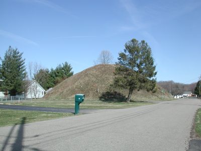
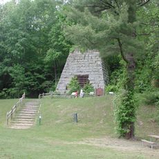
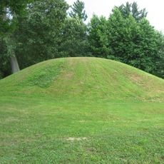
Wolf Plains is an archaeological site in Athens County containing roughly 30 prehistoric structures, including 22 conical mounds and 9 circular enclosures spread across a glacial terrace. The arrangement and varying sizes of these earthworks indicate they were constructed purposefully over an extended period.

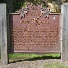
The structures were built by Adena peoples and date back several thousand years to their occupation of the region. The site received recognition from the National Register of Historic Places in 1974, marking its importance to the archaeological record.

The mounds reflect the skills and spiritual beliefs of ancient peoples who shaped the land through careful construction over generations. These earthworks served as gathering places and burial sites, anchoring the communities that built them to this specific landscape.

The Archaeological Conservancy maintains the Dorr 2 Mound, which visitors can explore with guidance or on their own. Most other structures sit on private land, so checking access possibilities in advance helps plan a meaningful visit.

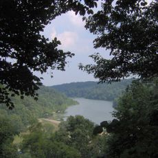
The proximity to the Hocking River likely influenced the location choice, making water access and resource availability key factors in settlement decisions. This positioning reveals how early peoples adapted to and depended on natural features when choosing where to build.

The community of curious travelers

AroundUs brings together thousands of curated places, local tips, and hidden gems, enriched daily by 60,000 contributors worldwide.

Start exploring
Location
GPS coordinates
39.37500,-82.12417
Latest update
December 12, 2025 17:45
Around this place
Peden Stadium
United States of America

Peden Stadium

6.3 km
Burr Oak State Park
United States of America

Burr Oak State Park

20.5 km
United States of America

Hocking Valley Scenic Railway Historic District

13.4 km
Strouds Run State Park
United States of America

Strouds Run State Park

9.4 km
Zaleski State Forest
United States of America

Zaleski State Forest

25.2 km
Manasseh Cutler Hall
United States of America

Manasseh Cutler Hall

5.8 km
Hope Furnace
United States of America

Hope Furnace

19.2 km
Zaleski Mound Group
United States of America

Zaleski Mound Group

25.3 km
United States of America

Lake Snowden

15 km
Athena Cinema
United States of America

Athena Cinema

5.6 km
John Calhoun Baker University Center
United States of America

John Calhoun Baker University Center

5.9 km
College Green of Ohio University
United States of America

College Green of Ohio University

5.8 km
Stuart's Opera House
United States of America

Stuart's Opera House

13.3 km
Athens Governmental Buildings
United States of America

Athens Governmental Buildings

5.8 km
Athens State Hospital Cow Barn
United States of America

Athens State Hospital Cow Barn

6.8 km
Athens Downtown Historic District
United States of America

Athens Downtown Historic District

5.4 km
Blackwood Covered Bridge
United States of America

Blackwood Covered Bridge

23.6 km
Strouds Ridge Preserve
United States of America

Strouds Ridge Preserve

6 km
Kidwell Covered Bridge
United States of America

Kidwell Covered Bridge

9.2 km
Savage-Stewart House
United States of America

Savage-Stewart House

14.6 km
Palos Covered Bridge
United States of America

Palos Covered Bridge

17.3 km
Trimble Township Community Forest
United States of America

Trimble Township Community Forest

17 km
Lake Hope State Park
United States of America

Lake Hope State Park

20.2 km
Kennedy Museum of Art
United States of America

Kennedy Museum of Art

6.2 km
Mount Zion Baptist Church
United States of America

Mount Zion Baptist Church

5.1 km
Shawnee Lookout Tower
United States of America

Shawnee Lookout Tower

21.3 km
Hope Furnace
United States of America

Hope Furnace

19.2 km
Haydenville Historic Town
United States of America

Haydenville Historic Town

21 km
Show the full map
Reviews
Share your experience

No review yet

Discussions
Start a discussion...

No discussion yet

« Wolf Plains - Archaeological site in Athens County, Ohio » is provided by Around Us (aroundus.com). Images and texts are derived from Wikimedia project under a Creative Commons license. You are allowed to copy, distribute, and modify copies of this page, under the conditions set by the license, as long as this note is clearly visible.

Discover hidden gems everywhere you go!

From secret cafés to breathtaking viewpoints, skip the crowded tourist spots and find places that match your style. Our app makes it easy with voice search, smart filtering, route optimization, and insider tips from travelers worldwide. Download now for the complete mobile experience.

Around Us App Screenshot

A unique approach to discovering new places

Le Figaro

All the places worth exploring

France Info

A tailor-made excursion in just a few clicks

20 Minutes

Around Us
Travel Guide & Maps
Download

Send to your phone

QR Code
1

Open the camera app on your mobile.

2

Point at the QR code with your camera. A notification will appear.

3

Tap the notification to open the link.