Chest opened
+${chestReward.xp} XP
Explorer
NOUVEAU ×${chestReward.collectible.quantity}
tapez pour fermer
Chest locked

Open chests in the app

Around Us is built for your phone — chests unlock when you walk, explore and capture nearby places.

Enable Location

We need your location to show you interesting places around you

Discover nearby places

Find interesting locations and hidden gems around you

Precise directions

Get accurate directions and distances to places

Your location is never shared with other users. It's only used when you tap the location button.

Log in to your account

Start exploring — it's free

Trusted by 72,876 travelers worldwide

Continue with Google
Continue with Apple
or

We will send you a code to connect

By continuing, you accept our Terms and Conditions and our Privacy Policy

Check your inbox

We've sent a pincode in your inbox. Please enter the code below.

Yorks Islands
Discussion Reviews Photo
1.6k Popularity

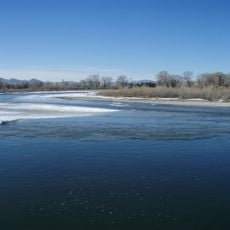
Yorks Islands, River islands in Missouri River near Townsend, Montana, US.

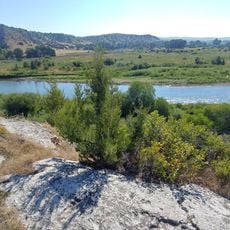
Yorks Islands is a group of small islands that spread across the Missouri River floodplain, creating natural formations within the waterway about 4 miles south of Townsend. These scattered land masses form distinct structures in the river system.

The islands were documented by the Lewis and Clark Expedition in 1805 when they mapped them during their journey through Montana Territory. This marked an important point in the early survey and exploration of the western region.

The islands are named after York, an enslaved man who was part of the Lewis and Clark Expedition and played an important role in exploring the American West. Visitors sense this historical connection while moving through the quiet waterway and natural surroundings.

The fishing access site offers over 20 acres of space with boat launches and fishing spots along the Missouri River. Camping is available, and visitors should prepare for varying water levels and currents that change with the season.

The official name 'Yorks Islands' was not recognized by the U.S. Board on Geographic Names until 2000, nearly two centuries after they were first explored. This delayed recognition reflects how long it took for the contributions of York and other expedition members to receive formal acknowledgment.

The community of curious travelers

AroundUs brings together thousands of curated places, local tips, and hidden gems, enriched daily by 60,000 contributors worldwide.

Start exploring
Location
GPS coordinates
46.26250,-111.49100
Latest update
December 21, 2025 16:05
Around this place
Missouri Headwaters State Park
United States of America

Missouri Headwaters State Park

38.1 km
United States of America

Montana Governor's Residence

53.7 km
Madison Buffalo Jump State Park
United States of America

Madison Buffalo Jump State Park

52.2 km
Canyon Ferry Dam
United States of America

Canyon Ferry Dam

46.6 km
Sacajawea Hotel
United States of America

Sacajawea Hotel

41.1 km
Helena Historic District
United States of America

Helena Historic District

54.8 km
Boulder Hot Springs Hotel
United States of America

Boulder Hot Springs Hotel

46.8 km
Kluge House
United States of America

Kluge House

49.6 km
St. Joseph's Catholic Mission Church
United States of America

St. Joseph's Catholic Mission Church

16.6 km
Montana Deaf and Dumb Asylum
United States of America

Montana Deaf and Dumb Asylum

50.1 km
W.C. Child Ranch
United States of America

W.C. Child Ranch

46.9 km
State Bank of Townsend
United States of America

State Bank of Townsend

7.1 km
Toston Bridge
United States of America

Toston Bridge

10.7 km
Eagle Guard Station
United States of America

Eagle Guard Station

17.9 km
Fraternity Hall
United States of America

Fraternity Hall

35 km
Parberry Block East
United States of America

Parberry Block East

55.2 km
Porter Flats Apartments
United States of America

Porter Flats Apartments

55.2 km
Dry Creek School
United States of America

Dry Creek School

47.9 km
Jefferson County Courthouse
United States of America

Jefferson County Courthouse

48.6 km
Morris Silverman House
United States of America

Morris Silverman House

55.1 km
T. H. Kleinschmidt House
United States of America

T. H. Kleinschmidt House

53.3 km
Adams Block
United States of America

Adams Block

41.4 km
Robert and Elizabeth Fisk House
United States of America

Robert and Elizabeth Fisk House

55.1 km
Montana Veterans and Pioneers Memorial Building
United States of America

Montana Veterans and Pioneers Memorial Building

54 km
Wick-Seiler House
United States of America

Wick-Seiler House

54.9 km
Ling Rock - Ferry Crossing Headwaters State Park
United States of America

Ling Rock - Ferry Crossing Headwaters State Park

36.5 km
Bleu Horses
United States of America

Bleu Horses

32.6 km
Ruby Theatre
United States of America

Ruby Theatre

42.5 km
Show the full map
Reviews
Share your experience

No review yet

Discussions
Start a discussion...

No discussion yet

« Yorks Islands - River islands in Missouri River near Townsend, Montana, US » is provided by Around Us (aroundus.com). Images and texts are derived from Wikimedia project under a Creative Commons license. You are allowed to copy, distribute, and modify copies of this page, under the conditions set by the license, as long as this note is clearly visible.

Discover hidden gems everywhere you go!

From secret cafés to breathtaking viewpoints, skip the crowded tourist spots and find places that match your style. Our app makes it easy with voice search, smart filtering, route optimization, and insider tips from travelers worldwide. Download now for the complete mobile experience.

Around Us App Screenshot

A unique approach to discovering new places

Le Figaro

All the places worth exploring

France Info

A tailor-made excursion in just a few clicks

20 Minutes

Around Us
Travel Guide & Maps
Download

Send to your phone

QR Code
1

Open the camera app on your mobile.

2

Point at the QR code with your camera. A notification will appear.

3

Tap the notification to open the link.