Enable Location

We need your location to show you interesting places around you

Discover nearby places

Find interesting locations and hidden gems around you

Precise directions

Get accurate directions and distances to places

Your location is never shared with other users. It's only used when you tap the location button.

Huron Wetland Management District

Log in to your account

Start exploring — it's free

Trusted by 62,854 travelers worldwide

Continue with Google
Continue with Apple
or

We will send you a code to connect

By continuing, you accept our Terms and Conditions and our Privacy Policy

Check your inbox

We've sent a pincode in your inbox. Please enter the code below.

Huron Wetland Management District

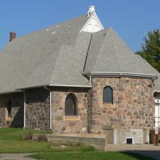
Huron Wetland Management District, Wetland management district in east-central South Dakota, United States.

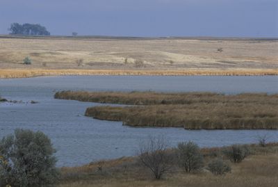
The Huron Wetland Management District is a designated area for wetland conservation across eight counties in the prairie pothole region of South Dakota. It contains multiple waterfowl production areas made up of shallow basins and grasslands that serve as breeding and stopover habitat.

The district received official designation in 1992 from the U.S. Fish and Wildlife Service. This protection was established to safeguard the wetlands and grasslands for long-term wildlife conservation across the region.

The Maga Ta-Hohpi area features accessible trails where visitors can watch and photograph numerous bird species living in their natural setting. People commonly observe waterfowl and migratory birds moving through the landscape throughout the year.

Visitors can enjoy various outdoor activities including hunting, fishing, wildlife photography, and nature study throughout the designated areas. The spring and fall seasons offer the best viewing opportunities when migrating birds pass through the region.

The wetlands formed from glacial activity that left behind shallow depressions across the landscape. These basins fill with water seasonally, creating temporary habitats that birds depend on during their journeys across North America.

The community of curious travelers

AroundUs brings together thousands of curated places, local tips, and hidden gems, enriched daily by 60,000 contributors worldwide.

Start exploring
Location
Inception
1992
GPS coordinates
44.40610,-98.41720
Latest update
December 14, 2025 18:02
Around this place
Ingalls House
United States of America

Ingalls House

68.6 km
Underwood United Methodist Church
United States of America

Underwood United Methodist Church

63.7 km
Pyle House
United States of America

Pyle House

17.3 km
Patten Consolidated School
United States of America

Patten Consolidated School

62.8 km
Aurora County Courthouse
United States of America

Aurora County Courthouse

76.8 km
Laura Ingalls Wilder Homestead
United States of America

Laura Ingalls Wilder Homestead

69.8 km
Bethel Church
United States of America

Bethel Church

33.6 km
Chicago and North Western Roundhouse
United States of America

Chicago and North Western Roundhouse

17.4 km
Grace Episcopal Church
United States of America

Grace Episcopal Church

17 km
Jerauld County Courthouse
United States of America

Jerauld County Courthouse

38.5 km
Hattie O. and Henry Drake Octagon House
United States of America

Hattie O. and Henry Drake Octagon House

16.1 km
Robert S. Vessey House
United States of America

Robert S. Vessey House

38.4 km
Methodist Episcopal Church of Wessington Springs
United States of America

Methodist Episcopal Church of Wessington Springs

38.4 km
Spink County Courthouse
United States of America

Spink County Courthouse

52.8 km
Clark County Courthouse
United States of America

Clark County Courthouse

75.5 km
Redfield Carnegie Library
United States of America

Redfield Carnegie Library

53 km
Raesly House
United States of America

Raesly House

76.8 km
Hofmeister House
United States of America

Hofmeister House

79 km
Thomas H. Ruth House
United States of America

Thomas H. Ruth House

68.9 km
Hilton House
United States of America

Hilton House

79 km
Wessington Springs Carnegie Library
United States of America

Wessington Springs Carnegie Library

38.4 km
Kingsbury County Courthouse
United States of America

Kingsbury County Courthouse

69.4 km
Old Redfield City Hall
United States of America

Old Redfield City Hall

53.1 km
Mitchell Prehistoric Indian Village
United States of America

Mitchell Prehistoric Indian Village

80 km
United States of America

South Dakota Department of Transportation Bridge No. 03-327-230

32.4 km
United States of America

McMonies Barn

19.2 km
Mitchell Site
United States of America

Mitchell Site

80.1 km
Wessington Springs Opera House
United States of America

Wessington Springs Opera House

38.3 km
Show the full map
« Huron Wetland Management District - Wetland management district in east-central South Dakota, United States » is provided by Around Us (aroundus.com). Images and texts are derived from Wikimedia project under a Creative Commons license. You are allowed to copy, distribute, and modify copies of this page, under the conditions set by the license, as long as this note is clearly visible.

Discover hidden gems everywhere you go!

From secret cafés to breathtaking viewpoints, skip the crowded tourist spots and find places that match your style. Our app makes it easy with voice search, smart filtering, route optimization, and insider tips from travelers worldwide. Download now for the complete mobile experience.

Around Us App Screenshot

A unique approach to discovering new places

Le Figaro

All the places worth exploring

France Info

A tailor-made excursion in just a few clicks

20 Minutes

Around Us
Travel Guide & Maps
Download

Send to your phone

QR Code
1

Open the camera app on your mobile.

2

Point at the QR code with your camera. A notification will appear.

3

Tap the notification to open the link.