Upper Buffalo Wilderness

Log in to your account

AroundUs is a community-driven map of interesting places, built by curious explorers like you. It grows with every review, story, and photo you share.
Connect to save your favorite spots, contribute locations, and create personalized routes.
Continue with Google
Continue with Apple
Continue with X
Continue with Facebook
Continue with email
By continuing, you accept our Terms and Conditions and our Privacy Policy
Create an account

Upper Buffalo Wilderness

Add to collection
Map
Suggest a change
Share

Upper Buffalo Wilderness, Wilderness area in Ozark National Forest, Arkansas

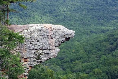
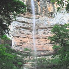
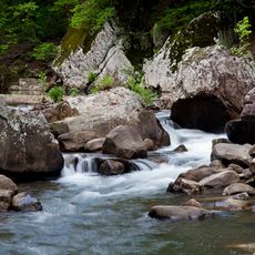
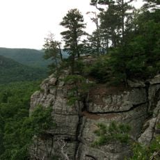
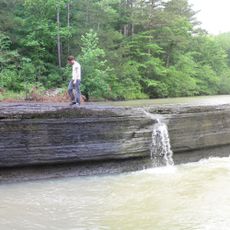
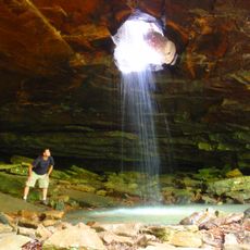
Upper Buffalo Wilderness is a large protected area in Ozark National Forest that covers over 11,000 acres of mountainous ground with steep slopes, scattered boulders, and multiple waterfalls along the Buffalo River. The terrain remains largely without developed trails, keeping it in its natural state.

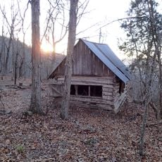
This area was officially designated as wilderness in 1975, after people had already left the region decades before. Remnants of earlier settlement remain visible today in the form of old stone walls, abandoned equipment, and cemeteries.

The area holds meaning for people who seek unmanaged nature and want to experience outdoor activities in their simplest form. Visitors can connect with the landscape the way it has existed for generations, without the influence of modern development.

Visitors should prepare for navigation without marked trails and bring good footwear along with maps or GPS devices. All water sources must be treated before drinking, even though they may appear clean.

During winter, small waterfalls freeze into eye-catching ice formations that transform the landscape. The area also supports an exceptionally high population of squirrels, among the densest found anywhere in the southern region.

Location: Arkansas

Inception: January 3, 1975

GPS coordinates: 35.89720,-93.45720

Latest update: December 12, 2025 07:59

Photos
Around this place
Dogpatch USA
United States of America

Dogpatch USA

37.4 km
Hemmed-In-Hollow Falls
United States of America

Hemmed-In-Hollow Falls

23.7 km
Richland Creek Wilderness
United States of America

Richland Creek Wilderness

0 m
Sam's Throne
United States of America

Sam's Throne

36.1 km
Parker-Hickman Farm Historic District
United States of America

Parker-Hickman Farm Historic District

28.7 km
Union School
United States of America

Union School

31.5 km
Madison County Courthouse
United States of America

Madison County Courthouse

32.9 km
Big Piney Creek Bridge
United States of America

Big Piney Creek Bridge

31.6 km
Shady Grove Delmar Church and School
United States of America

Shady Grove Delmar Church and School

31.2 km
Little Buffalo River Bridge
United States of America

Little Buffalo River Bridge

22.2 km
Harmony Presbyterian Church
United States of America

Harmony Presbyterian Church

39.9 km
Buffalo River Bridge
United States of America

Buffalo River Bridge

34.1 km
Villines Mill
United States of America

Villines Mill

11.7 km
Dog Branch School
United States of America

Dog Branch School

35.2 km
Bank of Kingston
United States of America

Bank of Kingston

17.9 km
Newton County Courthouse
United States of America

Newton County Courthouse

27.3 km
Ozone School
United States of America

Ozone School

29.7 km
Harp Creek Bridge
United States of America

Harp Creek Bridge

35.5 km
Jasper Commercial Historic District
United States of America

Jasper Commercial Historic District

27.4 km
Pettigrew School
United States of America

Pettigrew School

19.5 km
War Eagle Creek Bridge
United States of America

War Eagle Creek Bridge

33 km
Thomas J. Hankins House
United States of America

Thomas J. Hankins House

38 km
St. Paul School Building
United States of America

St. Paul School Building

29 km
Huntsville Commercial Historic District
United States of America

Huntsville Commercial Historic District

33 km
Flowers Cabin
United States of America

Flowers Cabin

23.8 km
Haw Creek Falls Recreation Area
United States of America

Haw Creek Falls Recreation Area

30.6 km
Mulberry River Bridge
United States of America

Mulberry River Bridge

42 km
Glory Hole Waterfall
United States of America

Glory Hole Waterfall

10.2 km
Show the full map
Reviews

Visited this place? Tap the stars to rate it and share your experience / photos with the community! Try now! You can cancel it anytime.

« Upper Buffalo Wilderness - Wilderness area in Ozark National Forest, Arkansas » is provided by Around Us (aroundus.com). Images and texts are derived from Wikimedia project under a Creative Commons license. You are allowed to copy, distribute, and modify copies of this page, under the conditions set by the license, as long as this note is clearly visible.

Discover hidden gems everywhere you go!

From secret cafés to breathtaking viewpoints, skip the crowded tourist spots and find places that match your style. Our app makes it easy with voice search, smart filtering, route optimization, and insider tips from travelers worldwide. Download now for the complete mobile experience.

Around Us App Screenshot

A unique approach to discovering new places

Le Figaro

All the places worth exploring

France Info

A tailor-made excursion in just a few clicks

20 Minutes