Wooddale Bridge

Log in to your account

AroundUs is a community-driven map of interesting places, built by curious explorers like you. It grows with every review, story, and photo you share.
Connect to save your favorite spots, contribute locations, and create personalized routes.
By continuing, you accept our Terms and Conditions and our Privacy Policy

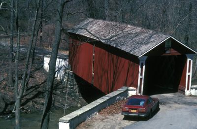
Wooddale Bridge, Covered bridge over Red Clay Creek in New Castle County, Delaware

The Wooddale Bridge extends 72 feet across Red Clay Creek with a wooden lattice truss design featuring diagonal planking and white painted trusses.

Built in 1850, the bridge was destroyed by Tropical Storm Henri in 2003 and underwent a complete reconstruction between 2007 and 2008 at a cost of 3.4 million dollars.

The bridge represents one of only three remaining covered bridges in Delaware, reflecting the engineering methods and architectural preferences of the mid-19th century United States.

Located at coordinates 39.7658, -75.6372, the bridge includes enlarged water flow openings and an elevated roadway positioned five feet higher for flood protection.

The reconstruction used Bongossi wood, known for its durability, and transformed the bridge into a geocaching location in 2011, adding a recreational dimension.

Location: Delaware

Inception: 1870

GPS coordinates: 39.76580,-75.63720

Latest update: September 23, 2025 16:45

Undiscovered treasures of Delaware

Delaware contains numerous natural reserves, state parks, and historical structures that remain undiscovered by many visitors. From coastal wetlands to botanical gardens, Civil War fortifications to Native American heritage sites, and covered bridges to wildlife sanctuaries, the state offers diverse locations for exploration. Natural attractions include northern cypress forests and salt marshes, while cultural sites feature museums, theaters, and colonial architecture.

Around this place
Show the full map
St. Joseph's on the Brandywine
United States of America

St. Joseph's on the Brandywine

4.2 km
Ashland Covered Bridge
United States of America

Ashland Covered Bridge

4 km
Wilmington and Western Railroad
United States of America

Wilmington and Western Railroad

3 km
Delaware Museum of Natural History
United States of America

Delaware Museum of Natural History

4.3 km
Jacob Broom House
United States of America

Jacob Broom House

3.1 km
Mount Cuba Astronomical Observatory
United States of America

Mount Cuba Astronomical Observatory

2.2 km
Coffee Run Mission Site
United States of America

Coffee Run Mission Site

1.9 km
Marshallton United Methodist Church
United States of America

Marshallton United Methodist Church

4.4 km
Brindley Farm
United States of America

Brindley Farm

3.8 km
Greenbank Historic Area
United States of America

Greenbank Historic Area

2.9 km
Red Clay Creek Presbyterian Church
United States of America

Red Clay Creek Presbyterian Church

3.4 km
Stockton-Montmorency
United States of America

Stockton-Montmorency

3 km
Fell Historic District
United States of America

Fell Historic District

1.9 km
Holladay-Harrington House
United States of America

Holladay-Harrington House

3.9 km
William Julius "Judy" Johnson House
United States of America

William Julius "Judy" Johnson House

4 km
A. Armstrong Farm
United States of America

A. Armstrong Farm

3.9 km
Charles Springer Tavern
United States of America

Charles Springer Tavern

1.5 km
Walnut Green School
United States of America

Walnut Green School

3.2 km
Mount Cuba Historic District
United States of America

Mount Cuba Historic District

2.6 km
James Armor House
United States of America

James Armor House

1.6 km
S. P. Dixon Farm
United States of America

S. P. Dixon Farm

3.8 km
Thomas Justis House
United States of America

Thomas Justis House

4 km
Hickman Blacksmith Shop and House
United States of America

Hickman Blacksmith Shop and House

4.1 km
J. Mason Farm
United States of America

J. Mason Farm

3.8 km
J. McCormack Farm
United States of America

J. McCormack Farm

2.1 km
Hersey-Duncan House
United States of America

Hersey-Duncan House

3.5 km
Wooddale Historic District
United States of America

Wooddale Historic District

365 m
Justis-Jones House
United States of America

Justis-Jones House

2.5 km
Show the full map

Reviews

Visited this place? Tap the stars to rate it and share your experience / photos with the community! Try now! You can cancel it anytime.

« Wooddale Bridge - Covered bridge over Red Clay Creek in New Castle County, Delaware » is provided by Around Us (aroundus.com). Images and texts are derived from Wikimedia project under a Creative Commons license. You are allowed to copy, distribute, and modify copies of this page, under the conditions set by the license, as long as this note is clearly visible.

Discover hidden gems everywhere you go!

From secret cafés to breathtaking viewpoints, skip the crowded tourist spots and find places that match your style. Our app makes it easy with voice search, smart filtering, route optimization, and insider tips from travelers worldwide. Download now for the complete mobile experience.

Around Us App Screenshot

A unique approach to discovering new places

Le Figaro

All the places worth exploring

France Info

A tailor-made excursion in just a few clicks

20 Minutes