Ashland Covered Bridge
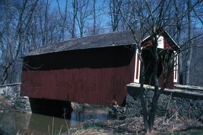
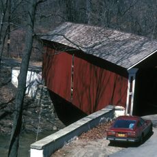
Ashland Covered Bridge, Covered bridge in New Castle County, Delaware
Description
Ashland Covered Bridge is a wooden structure crossing Red Clay Creek on Barley Mill Road with a red painted exterior and timber lattice framing inside. The bridge measures 16.5 meters in length and sits 5 feet (1.5 m) higher than its original position after being raised to prevent flooding.
History
The structure dates to 1870 and remains one of only three covered bridges surviving from that century in Delaware. It has survived storms and flooding, with restoration work keeping its original design intact.
Culture
The bridge represents traditional craftsmanship from the 1800s and shows how local builders solved practical problems with wood and simple geometry. Walking across it, you experience a building method that was common in rural Delaware during that era.
Practical
The bridge carries single-lane traffic and features height restriction signs to prevent large vehicles from entering and damaging the structure. Visit on foot or by car, but plan for slow passage and watch for weather conditions that may affect safety.
Did you know?
The structure sits adjacent to Ashland Nature Center and was reconstructed by specialists following storm damage while preserving its original architectural details. This restoration work shows how historical structures can be maintained for future generations.
AroundUs brings together thousands of curated places, local tips, and hidden gems, enriched daily by 60,000 contributors worldwide. Discover all places nearby (New Castle County).
Delaware maintains a network of natural areas, historic sites and cultural institutions distributed across its three counties. In northern New Castle County, visitors find railroad museums, botanical gardens and forested state parks along Brandywine Creek, while the southern Kent and Sussex counties...
Hindu Temple of Delaware
2.7 km
Auburn Valley State Park
2.2 km
Delaware Museum of Natural History
4.1 km
Owl's Nest Country Place
3.5 km
Garrett Snuff Mill
1.8 km
Jacob Broom House
1.4 km
Wooddale Bridge
4 km
Mount Cuba Astronomical Observatory
2.6 km
Hockessin Friends Meetinghouse
2.9 km
Coffee Run Mission Site
3.4 km
Auburn Mills Historic District
2.2 km
Cloud-Reese House
2.9 km
Garrett Snuff Mills Historic District
1.8 km
Stockton-Montmorency
2.7 km
Carpenter-Lippincott House
4.2 km
A. Armstrong Farm
1.9 km
Walnut Green School
2.8 km
Mount Cuba Historic District
1.8 km
Public School No. 29
3.8 km
S. P. Dixon Farm
279 m
Mt. Airy School No. 27
4.6 km
J. Mason Farm
573 m
Winterthur Galleries
5 km
Centreville Historic District
4.4 km
J. McCormack Farm
4.8 km
Graves Mill Historic District
1.4 km
Wooddale Historic District
3.7 km
Mt. Cuba Center
1.2 kmDiscover hidden gems everywhere you go!
From secret cafés to breathtaking viewpoints, skip the crowded tourist spots and find places that match your style. Our app makes it easy with voice search, smart filtering, route optimization, and insider tips from travelers worldwide. Download now for the complete mobile experience.
A unique approach to discovering new places❞
— Le Figaro
All the places worth exploring❞
— France Info
A tailor-made excursion in just a few clicks❞
— 20 Minutes