Enable Location

We need your location to show you interesting places around you

Discover nearby places

Find interesting locations and hidden gems around you

Precise directions

Get accurate directions and distances to places

Your location is never shared with other users. It's only used when you tap the location button.

Eldean Covered Bridge

Log in to your account

Start exploring — it's free

Trusted by 62,874 travelers worldwide

Continue with Google
Continue with Apple
or

We will send you a code to connect

By continuing, you accept our Terms and Conditions and our Privacy Policy

Check your inbox

We've sent a pincode in your inbox. Please enter the code below.

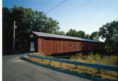
Eldean Covered Bridge, Covered bridge in Miami County, US.

Eldean Covered Bridge crosses the Great Miami River with two wooden spans supported by a central stone pier and stone abutments. The structure is completely enclosed with wooden shingles and features a roadway suitable for both vehicle and pedestrian passage.

Built in 1860 by the Hamilton brothers, this bridge served as a vital crossing for the community moving goods across the river. It became an important link in the regional network of transportation routes that developed during that era.

Locals and visitors walk or drive through daily, experiencing a structure that shaped how the community connected across the river for generations.

You can drive or walk through the bridge since the roadway accommodates both vehicles and pedestrians comfortably. The site is open to the public at any time, making it easy to visit whenever convenient.

The bridge uses a Long truss design system, a construction method that allows long spans to bridge the river without intermediate supports. This technical approach was advanced for its period and remains visible in how the wooden structure is arranged.

The community of curious travelers

AroundUs brings together thousands of curated places, local tips, and hidden gems, enriched daily by 60,000 contributors worldwide.

Start exploring
Location
GPS coordinates
40.07780,-84.21670
Latest update
December 14, 2025 11:05
Around this place
People's Federal Savings and Loan Association
United States of America

People's Federal Savings and Loan Association

23.5 km
Hobart Arena
United States of America

Hobart Arena

3.7 km
Lockington Locks
United States of America

Lockington Locks

14.8 km
African Jackson Cemetery
United States of America

African Jackson Cemetery

9 km
Whitby Mansion
United States of America

Whitby Mansion

24.2 km
Olive Branch High School
United States of America

Olive Branch High School

26.3 km
Miami County Courthouse
United States of America

Miami County Courthouse

4.2 km
Arrowston
United States of America

Arrowston

9.2 km
Overfield Tavern
United States of America

Overfield Tavern

4.5 km
Sidney Waterworks and Electric Light Building
United States of America

Sidney Waterworks and Electric Light Building

24 km
Fulton Farm
United States of America

Fulton Farm

22.8 km
Troy Public Square
United States of America

Troy Public Square

4.4 km
Casstown Lutheran Stone Church
United States of America

Casstown Lutheran Stone Church

8.1 km
Aullwood House and Garden
United States of America

Aullwood House and Garden

23.9 km
Arnold Homestead
United States of America

Arnold Homestead

25.1 km
St. Peter's Evangelical Lutheran Church
United States of America

St. Peter's Evangelical Lutheran Church

24.9 km
Sidney Walnut Avenue Historic District
United States of America

Sidney Walnut Avenue Historic District

23.7 km
Kroger Aquatic Center
United States of America

Kroger Aquatic Center

24.2 km
Wilson-Lenox House
United States of America

Wilson-Lenox House

20 km
Ausenbaugh-McElhenny House
United States of America

Ausenbaugh-McElhenny House

26 km
John Minor Dye Stone House
United States of America

John Minor Dye Stone House

8.7 km
Old Piqua High School
United States of America

Old Piqua High School

8.4 km
Halderman Museum Barn
United States of America

Halderman Museum Barn

22.2 km
WACO Air Museum & Aviation Learning Center
United States of America

WACO Air Museum & Aviation Learning Center

7.4 km
Monitor House
United States of America

Monitor House

22 km
The Shelby County Courthouse
United States of America

The Shelby County Courthouse

23.6 km
Forest Hill Union Cemetery
United States of America

Forest Hill Union Cemetery

10.3 km
Peoples Federal Savings and Loan Association
United States of America

Peoples Federal Savings and Loan Association

23.5 km
Show the full map
« Eldean Covered Bridge - Covered bridge in Miami County, US » is provided by Around Us (aroundus.com). Images and texts are derived from Wikimedia project under a Creative Commons license. You are allowed to copy, distribute, and modify copies of this page, under the conditions set by the license, as long as this note is clearly visible.

Discover hidden gems everywhere you go!

From secret cafés to breathtaking viewpoints, skip the crowded tourist spots and find places that match your style. Our app makes it easy with voice search, smart filtering, route optimization, and insider tips from travelers worldwide. Download now for the complete mobile experience.

Around Us App Screenshot

A unique approach to discovering new places

Le Figaro

All the places worth exploring

France Info

A tailor-made excursion in just a few clicks

20 Minutes

Around Us
Travel Guide & Maps
Download

Send to your phone

QR Code
1

Open the camera app on your mobile.

2

Point at the QR code with your camera. A notification will appear.

3

Tap the notification to open the link.