Enable Location

We need your location to show you interesting places around you

Discover nearby places

Find interesting locations and hidden gems around you

Precise directions

Get accurate directions and distances to places

Your location is never shared with other users. It's only used when you tap the location button.

Log in to your account

Start exploring — it's free

Trusted by 63,696 travelers worldwide

Continue with Google
Continue with Apple
or

We will send you a code to connect

By continuing, you accept our Terms and Conditions and our Privacy Policy

Check your inbox

We've sent a pincode in your inbox. Please enter the code below.

Cheraw State Park
Discussion Reviews Photo
3.1k Popularity

Cheraw State Park, State park and recreation area near Cheraw, United States.

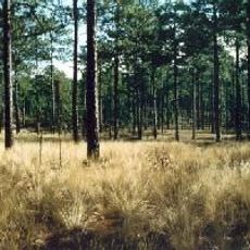
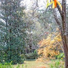
Cheraw State Park is a large recreation area in northeastern South Carolina that features Lake Juniper and expansive pine forests. The site offers hiking trails, camping options, vacation cabins, and an 18-hole golf course for visitors.

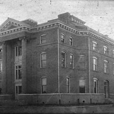
The park was established in the 1930s by the Civilian Conservation Corps, a nationwide program that created public recreational spaces across America. This project represented part of a larger effort to develop protected areas and outdoor facilities throughout the country.

The park serves as a center for outdoor education, offering programs about local flora, fauna, and ecological systems throughout the year.

The park is open year-round and offers a range of activities from hiking to golfing for different skill levels. The best time to visit is from May through October when weather conditions are mild and trails are in their best condition.

The forest area is home to red-cockaded woodpeckers, a rare bird species that nests only in living pine trees. This species is threatened throughout North America, making the woodland an important refuge.

The community of curious travelers

AroundUs brings together thousands of curated places, local tips, and hidden gems, enriched daily by 60,000 contributors worldwide.

Start exploring
Location
Inception
1934
GPS coordinates
34.64750,-79.89430
Latest update
December 12, 2025 09:07
Around this place
Carolina Sandhills National Wildlife Refuge
United States of America

Carolina Sandhills National Wildlife Refuge

31.8 km
St. David's Episcopal Church and Cemetery
United States of America

St. David's Episcopal Church and Cemetery

5.5 km
Covington Plantation House
United States of America

Covington Plantation House

29 km
Rockingham County Courthouse
United States of America

Rockingham County Courthouse

34.1 km
Pegues Place
United States of America

Pegues Place

17.1 km
Robert Smalls School
United States of America

Robert Smalls School

6.1 km
Bennettsville Historic District
United States of America

Bennettsville Historic District

19.8 km
Clio Historic District
United States of America

Clio Historic District

32.7 km
Main Street Commercial Historic District
United States of America

Main Street Commercial Historic District

31.8 km
U. S. Post Office and Federal Building
United States of America

U. S. Post Office and Federal Building

34 km
Jennings-Brown House
United States of America

Jennings-Brown House

20.1 km
Magnolia House
United States of America

Magnolia House

20.1 km
Cheraw Historic District
United States of America

Cheraw Historic District

5.6 km
Robertson-Easterling-McLaurin House
United States of America

Robertson-Easterling-McLaurin House

13 km
Memorial Hall
United States of America

Memorial Hall

33.9 km
McLaurin House
United States of America

McLaurin House

33.9 km
McLaurin-Roper-McColl Farmstead
United States of America

McLaurin-Roper-McColl Farmstead

30.4 km
Manship Farmstead
United States of America

Manship Farmstead

27.3 km
Richmond County Courthouse
United States of America

Richmond County Courthouse

34.1 km
East Main Street Historic District (Chesterfield, South Carolina)
United States of America

East Main Street Historic District (Chesterfield, South Carolina)

19.9 km
J.B. Gilbert House
United States of America

J.B. Gilbert House

34 km
H. C. Watson House
United States of America

H. C. Watson House

33.5 km
Appin
United States of America

Appin

16.9 km
Lawton Park and Pavilion
United States of America

Lawton Park and Pavilion

34.1 km
West Main Street Historic District (Chesterfield, South Carolina)
United States of America

West Main Street Historic District (Chesterfield, South Carolina)

20.6 km
Davidson Hall, Coker College
United States of America

Davidson Hall, Coker College

34 km
Dr. Thomas E. Lucas House
United States of America

Dr. Thomas E. Lucas House

20.9 km
East Home Avenue Historic District
United States of America

East Home Avenue Historic District

34 km
Show the full map
Reviews
Share your experience

No review yet

Discussions
Start a discussion...

No discussion yet

« Cheraw State Park - State park and recreation area near Cheraw, United States » is provided by Around Us (aroundus.com). Images and texts are derived from Wikimedia project under a Creative Commons license. You are allowed to copy, distribute, and modify copies of this page, under the conditions set by the license, as long as this note is clearly visible.

Discover hidden gems everywhere you go!

From secret cafés to breathtaking viewpoints, skip the crowded tourist spots and find places that match your style. Our app makes it easy with voice search, smart filtering, route optimization, and insider tips from travelers worldwide. Download now for the complete mobile experience.

Around Us App Screenshot

A unique approach to discovering new places

Le Figaro

All the places worth exploring

France Info

A tailor-made excursion in just a few clicks

20 Minutes

Around Us
Travel Guide & Maps
Download

Send to your phone

QR Code
1

Open the camera app on your mobile.

2

Point at the QR code with your camera. A notification will appear.

3

Tap the notification to open the link.