Enable Location

We need your location to show you interesting places around you

Discover nearby places

Find interesting locations and hidden gems around you

Precise directions

Get accurate directions and distances to places

Your location is never shared with other users. It's only used when you tap the location button.

Sulphite Railroad Bridge

Log in to your account

Start exploring — it's free

Trusted by 62,972 travelers worldwide

Continue with Google
Continue with Apple
or

We will send you a code to connect

By continuing, you accept our Terms and Conditions and our Privacy Policy

Check your inbox

We've sent a pincode in your inbox. Please enter the code below.

Discussion Reviews 1 Photos
1.9k Popularity

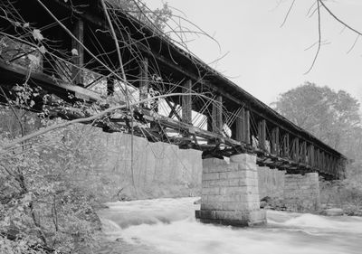
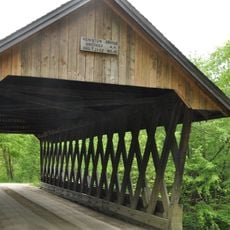
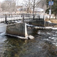
Sulphite Railroad Bridge, Railroad bridge in Franklin, United States.

The Sulphite Railroad Bridge spans across the Winnipesaukee River with three sections supported by granite piers and Pratt trusses beneath the railbed. The structure features an unconventional arrangement with railroad tracks positioned above the trusses rather than beneath them.

The structure was built in 1896 by the Boston and Maine Railroad to replace an earlier trestle bridge from 1892. Operations ceased in 1973 when the railroad line lost its importance for freight transport in the region.

The bridge takes its name from the sulfur that was transported to paper mills in Franklin, which served as the economic backbone of the community until the 1920s. This industrial purpose defined the local identity for several generations.

The bridge is accessible from Trestle View Park, where free parking is available for visitors starting their walk along the Winnipesaukee River Trail. The short walk from the park provides an easy approach to view the structure up close.

The structure features a rare design where railroad tracks are positioned above the trusses rather than beneath them. This makes it the last remaining example of this inverted building method in the United States.

The community of curious travelers

AroundUs brings together thousands of curated places, local tips, and hidden gems, enriched daily by 60,000 contributors worldwide.

Start exploring
Location
GPS coordinates
43.44530,-71.63610
Latest update
December 14, 2025 11:44
Around this place
Memorial Arch of Tilton
United States of America

Memorial Arch of Tilton

3.9 km
House by the Side of the Road
United States of America

House by the Side of the Road

3.7 km
Daniel Webster Family Home
United States of America

Daniel Webster Family Home

4.5 km
Charles E. Tilton Mansion
United States of America

Charles E. Tilton Mansion

3.6 km
Concord Historic District
United States of America

Concord Historic District

0 m
Ahern State Park
United States of America

Ahern State Park

16.5 km
Old Webster Meeting House
United States of America

Old Webster Meeting House

14.5 km
Laconia District Court
United States of America

Laconia District Court

16 km
Keniston Bridge
United States of America

Keniston Bridge

16.3 km
Gale Memorial Library
United States of America

Gale Memorial Library

16.3 km
Tilton Island Park Bridge
United States of America

Tilton Island Park Bridge

4 km
Colonial Theatre Complex
United States of America

Colonial Theatre Complex

16.3 km
Belmont Public Library
United States of America

Belmont Public Library

12.4 km
Boscawen Public Library
United States of America

Boscawen Public Library

14.1 km
Salisbury Academy Building
United States of America

Salisbury Academy Building

9.7 km
Morrill-Lassonde House
United States of America

Morrill-Lassonde House

15.5 km
Hill Center Church
United States of America

Hill Center Church

10.1 km
Federal Building
United States of America

Federal Building

16.3 km
East Andover Village Center Historic District
United States of America

East Andover Village Center Historic District

9.1 km
John W. Busiel House
United States of America

John W. Busiel House

16.3 km
Bay Meeting House and Vestry
United States of America

Bay Meeting House and Vestry

13.1 km
Tilton Downtown Historic District
United States of America

Tilton Downtown Historic District

3.7 km
First Congregational Church of Boscawen
United States of America

First Congregational Church of Boscawen

13.7 km
Gershom Durgin House
United States of America

Gershom Durgin House

10.9 km
Sanbornton Square Historic District
United States of America

Sanbornton Square Historic District

6.8 km
Hersey Farms Historic District
United States of America

Hersey Farms Historic District

8.2 km
Franklin Falls Historic District
United States of America

Franklin Falls Historic District

860 m
Hall Memorial Library
United States of America

Hall Memorial Library

3.5 km
Show the full map
Reviews
Share your experience

No review yet

Discussions
Start a discussion...

No discussion yet

« Sulphite Railroad Bridge - Railroad bridge in Franklin, United States » is provided by Around Us (aroundus.com). Images and texts are derived from Wikimedia project under a Creative Commons license. You are allowed to copy, distribute, and modify copies of this page, under the conditions set by the license, as long as this note is clearly visible.

Discover hidden gems everywhere you go!

From secret cafés to breathtaking viewpoints, skip the crowded tourist spots and find places that match your style. Our app makes it easy with voice search, smart filtering, route optimization, and insider tips from travelers worldwide. Download now for the complete mobile experience.

Around Us App Screenshot

A unique approach to discovering new places

Le Figaro

All the places worth exploring

France Info

A tailor-made excursion in just a few clicks

20 Minutes

Around Us
Travel Guide & Maps
Download

Send to your phone

QR Code
1

Open the camera app on your mobile.

2

Point at the QR code with your camera. A notification will appear.

3

Tap the notification to open the link.