Enable Location

We need your location to show you interesting places around you

Discover nearby places

Find interesting locations and hidden gems around you

Precise directions

Get accurate directions and distances to places

Your location is never shared with other users. It's only used when you tap the location button.

Jones Falls Trail

Log in to your account

Start exploring — it's free

Trusted by 62,413 travelers worldwide

Continue with Google
Continue with Apple
or

We will send you a code to connect

By continuing, you accept our Terms and Conditions and our Privacy Policy

Check your inbox

We've sent a pincode in your inbox. Please enter the code below.

Jones Falls Trail

Jones Falls Trail, hiking and bicycling trail in Baltimore, Maryland, United States

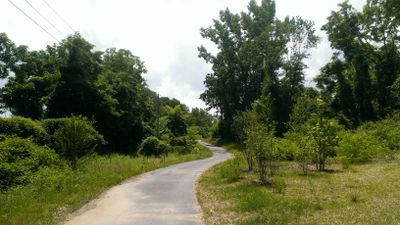
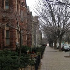
Jones Falls Trail is a walking and cycling path that winds through Baltimore along a creek, connecting various neighborhoods and parks. The route runs north from the busy Inner Harbor area past brick buildings, green spaces, and flowing water.

The creek that the trail follows once powered mills and supplied water to residents before parts of it were diverted underground. The path preserves this historical waterway and keeps its importance to Baltimore's past visible.

The trail follows a waterway that has shaped daily life in the city for generations. Residents use it regularly to jog, walk, or move between neighborhoods, showing how this place connects different parts of Baltimore and serves as a common gathering point.

The path has smooth, level surfaces suitable for wheelchairs and strollers, and is open year-round. Benches are placed along the way for rest, trees provide shade on hot days, and parking and public transit are nearby.

Some sections of the creek that were buried underground have been made visible again along this route, showing visitors how the city once hid its waterway. Signs and plaques tell stories about the creek and its role in shaping Baltimore's growth.

The community of curious travelers

AroundUs brings together thousands of curated places, local tips, and hidden gems, enriched daily by 60,000 contributors worldwide.

Start exploring
Location
Inception
1999
GPS coordinates
39.31748,-76.63157
Latest update
February 7, 2026 11:40
Around this place
Baltimore Museum of Art
United States of America

Baltimore Museum of Art

1.4 km
Druid Hill Park
United States of America

Druid Hill Park

1.3 km
Baltimore Streetcar Museum
United States of America

Baltimore Streetcar Museum

1.2 km
Confederate Soldiers and Sailors Monument
United States of America

Confederate Soldiers and Sailors Monument

1.2 km
United States of America

Miracle on 34th Street

1.3 km
Arch Social Club
United States of America

Arch Social Club

1.1 km
Old Goucher College Buildings
United States of America

Old Goucher College Buildings

1.4 km
Union Soldiers and Sailors Monument
United States of America

Union Soldiers and Sailors Monument

1.4 km
Eutaw Place Temple
United States of America

Eutaw Place Temple

1.5 km
West Baltimore Innovation District
United States of America

West Baltimore Innovation District

751 m
North Avenue Ice Palace
United States of America

North Avenue Ice Palace

1.5 km
Stone Hill Historic District
United States of America

Stone Hill Historic District

674 m
Baltimore Hebrew Congregation Synagogue
United States of America

Baltimore Hebrew Congregation Synagogue

1.1 km
David Bachrach House
United States of America

David Bachrach House

534 m
James E. Hooper House
United States of America

James E. Hooper House

1.4 km
Graffiti Alley
United States of America

Graffiti Alley

1.3 km
Evergreen on the Falls
United States of America

Evergreen on the Falls

1.1 km
Grace-Hampden Methodist Episcopal Church
United States of America

Grace-Hampden Methodist Episcopal Church

1.5 km
Riviera Apartments
United States of America

Riviera Apartments

434 m
Lake Drive Apartments
United States of America

Lake Drive Apartments

467 m
Eutaw-Madison Apartment House Historic District
United States of America

Eutaw-Madison Apartment House Historic District

628 m
Masjid Ul-Haqq
United States of America

Masjid Ul-Haqq

1.4 km
Howard Peters Rawlings Conservatory and Botanic Gardens of Baltimore
United States of America

Howard Peters Rawlings Conservatory and Botanic Gardens of Baltimore

1.3 km
Church of St. Michael and All Angels (Baltimore)
United States of America

Church of St. Michael and All Angels (Baltimore)

1.6 km
St. Mark's Evangelical Lutheran Church (Baltimore)
United States of America

St. Mark's Evangelical Lutheran Church (Baltimore)

1.5 km
Bolton Hill Historic District
United States of America

Bolton Hill Historic District

338 m
Howard Street Bridge
United States of America

Howard Street Bridge

1.4 km
Druid Lake
United States of America

Druid Lake

420 m
Show the full map
« Jones Falls Trail - hiking and bicycling trail in Baltimore, Maryland, United States » is provided by Around Us (aroundus.com). Images and texts are derived from Wikimedia project under a Creative Commons license. You are allowed to copy, distribute, and modify copies of this page, under the conditions set by the license, as long as this note is clearly visible.

Discover hidden gems everywhere you go!

From secret cafés to breathtaking viewpoints, skip the crowded tourist spots and find places that match your style. Our app makes it easy with voice search, smart filtering, route optimization, and insider tips from travelers worldwide. Download now for the complete mobile experience.

Around Us App Screenshot

A unique approach to discovering new places

Le Figaro

All the places worth exploring

France Info

A tailor-made excursion in just a few clicks

20 Minutes

Around Us
Travel Guide & Maps
Download

Send to your phone

QR Code
1

Open the camera app on your mobile.

2

Point at the QR code with your camera. A notification will appear.

3

Tap the notification to open the link.