Chest opened
+${chestReward.xp} XP
Explorer
NOUVEAU ×${chestReward.collectible.quantity}
tapez pour fermer
Chest locked

Open chests in the app

Around Us is built for your phone — chests unlock when you walk, explore and capture nearby places.

Enable Location

We need your location to show you interesting places around you

Discover nearby places

Find interesting locations and hidden gems around you

Precise directions

Get accurate directions and distances to places

Your location is never shared with other users. It's only used when you tap the location button.

Log in to your account

Start exploring — it's free

Trusted by 73,037 travelers worldwide

Continue with Google
Continue with Apple
or

We will send you a code to connect

By continuing, you accept our Terms and Conditions and our Privacy Policy

Check your inbox

We've sent a pincode in your inbox. Please enter the code below.

The Walls of Jericho
Discussion Reviews Photo
5.1k Popularity

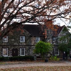
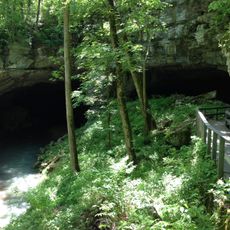
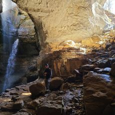
The Walls of Jericho, Natural amphitheater in Franklin County, Tennessee.

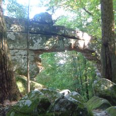
The Walls of Jericho is a large bowl-shaped canyon formed by limestone cliffs that rise roughly 200 feet, carved by Turkey Creek flowing through the valley over thousands of years. The gorge extends across two states with steep stone walls that frame a narrow, winding creek bed at its floor.

An oil magnate from Texas purchased the property in the 1940s when it was much larger, spanning across multiple counties in Tennessee. The site eventually became a protected natural area managed for public access and conservation purposes.

A traveling minister baptized people here in the late 1800s, and the biblical name stuck because of that practice. Today the canyon remains a place where water and rock have shaped the landscape in visible, powerful ways.

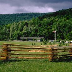
A marked hiking trail runs through the canyon between trailheads on both sides, suitable for different skill levels with regular water access. A primitive camping area sits midway through the gorge for visitors planning overnight trips.

The limestone walls contain large spherical holes as big as bowling balls, created by continuous dripping and spouting water carving into the stone. These round cavities demonstrate how patient erosion by water can bore into solid rock over extended periods.

The community of curious travelers

AroundUs brings together thousands of curated places, local tips, and hidden gems, enriched daily by 60,000 contributors worldwide.

Start exploring
GPS coordinates
34.99004,-86.10295
Latest update
December 10, 2025 16:30
Around this place
RyeMabee
United States of America

RyeMabee

37.3 km
Cowan Tunnel
United States of America

Cowan Tunnel

21.5 km
Sewanee Natural Bridge
United States of America

Sewanee Natural Bridge

24.6 km
United States of America

Lost Cove Cave

22.7 km
Fort Harker
United States of America

Fort Harker

28.1 km
Hundred Oaks Castle
United States of America

Hundred Oaks Castle

21.2 km
New Market Historic District
United States of America

New Market Historic District

31.1 km
New Market Presbyterian Church
United States of America

New Market Presbyterian Church

31.1 km
General William Rosecrans Headquarters
United States of America

General William Rosecrans Headquarters

27.6 km
Bridgeport Depot Museum
United States of America

Bridgeport Depot Museum

36.1 km
Bridgeport Historic District
United States of America

Bridgeport Historic District

36.1 km
McCartney-Bone House
United States of America

McCartney-Bone House

35.4 km
Haynes House
United States of America

Haynes House

24.9 km
Asia School
United States of America

Asia School

28.3 km
Franklin County Courthouse
United States of America

Franklin County Courthouse

21.9 km
Brown-Proctor House
United States of America

Brown-Proctor House

35.9 km
Skyline Commissary
United States of America

Skyline Commissary

19.8 km
Valentine Square
United States of America

Valentine Square

21.7 km
Hunt-Moore House
United States of America

Hunt-Moore House

16.9 km
Stevenson Historic District
United States of America

Stevenson Historic District

27.6 km
Whitman-Cobb House
United States of America

Whitman-Cobb House

31.3 km
Estill-Fite House
United States of America

Estill-Fite House

22.4 km
Russell Cave
United States of America

Russell Cave

26.8 km
Sewanee Fire Lookout Tower
United States of America

Sewanee Fire Lookout Tower

32.2 km
Stephen's Gap Trail
United States of America

Stephen's Gap Trail

37.1 km
New Market United Methodist Church
United States of America

New Market United Methodist Church

30.9 km
Gilbert H. Grosvenor Visitor Center
United States of America

Gilbert H. Grosvenor Visitor Center

26.8 km
R.N. Mann House
United States of America

R.N. Mann House

18.7 km
Show the full map
Reviews
Share your experience

No review yet

Discussions
Start a discussion...

No discussion yet

« The Walls of Jericho - Natural amphitheater in Franklin County, Tennessee » is provided by Around Us (aroundus.com). Images and texts are derived from Wikimedia project under a Creative Commons license. You are allowed to copy, distribute, and modify copies of this page, under the conditions set by the license, as long as this note is clearly visible.

Discover hidden gems everywhere you go!

From secret cafés to breathtaking viewpoints, skip the crowded tourist spots and find places that match your style. Our app makes it easy with voice search, smart filtering, route optimization, and insider tips from travelers worldwide. Download now for the complete mobile experience.

Around Us App Screenshot

A unique approach to discovering new places

Le Figaro

All the places worth exploring

France Info

A tailor-made excursion in just a few clicks

20 Minutes

Around Us
Travel Guide & Maps
Download

Send to your phone

QR Code
1

Open the camera app on your mobile.

2

Point at the QR code with your camera. A notification will appear.

3

Tap the notification to open the link.