Sewanee Natural Bridge

Log in to your account

AroundUs is a community-driven map of interesting places, built by curious explorers like you. It grows with every review, story, and photo you share.
Connect to save your favorite spots, contribute locations, and create personalized routes.
By continuing, you accept our Terms and Conditions and our Privacy Policy

Sewanee Natural Bridge

Add to collection
Map
Suggest a change
Share

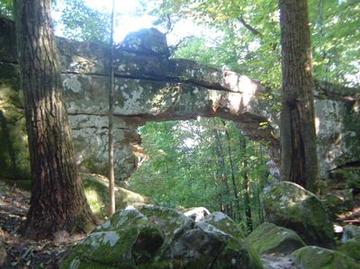
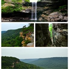
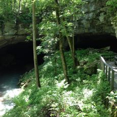
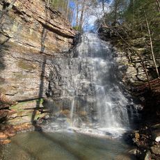
Sewanee Natural Bridge, Natural sandstone arch in Franklin County, Tennessee, United States.

Sewanee Natural Bridge is a sandstone arch formation in Franklin County, Tennessee. The structure rises approximately 25 feet (7 meters) high and spans roughly 50 feet (15 meters) across, creating a natural opening above the surrounding forested terrain.

The arch formation developed over thousands of years through erosion shaped by water and climate exposure. The University of the South in Sewanee acquired the land and helped establish the site as a protected natural area.

The Silver Jews, an alternative rock band, named their 1996 album 'The Natural Bridge' after this geological structure in Tennessee.

The site is best reached by driving south on Highway 56 from Sewanee and turning onto Natural Bridge Road. The location is straightforward to visit, especially during dry weather when the paths around the formation are easier to walk.

A small spring in a rock cave behind the arch played a key role in shaping the formation. This water source eroded the sandstone gradually over time, creating the distinctive arch shape seen today.

Location: Tennessee

GPS coordinates: 35.15370,-85.92150

Latest update: December 12, 2025 09:01

Photos
Around this place
Arnold Air Force Base
United States of America

Arnold Air Force Base

30.5 km
Nickajack Cave
United States of America

Nickajack Cave

33.7 km
RyeMabee
United States of America

RyeMabee

12.7 km
Fiery Gizzard Trail
United States of America

Fiery Gizzard Trail

19.5 km
Nickajack Lake
United States of America

Nickajack Lake

32.2 km
South Cumberland State Park
United States of America

South Cumberland State Park

16.8 km
Lost Cove Cave
United States of America

Lost Cove Cave

3.9 km
DuBose Conference Center
United States of America

DuBose Conference Center

13 km
Fort Harker
United States of America

Fort Harker

32.7 km
Hundred Oaks Castle
United States of America

Hundred Oaks Castle

18.5 km
General William Rosecrans Headquarters
United States of America

General William Rosecrans Headquarters

32.2 km
Bridgeport Depot Museum
United States of America

Bridgeport Depot Museum

29.8 km
Bridgeport Historic District
United States of America

Bridgeport Historic District

29.8 km
Haynes House
United States of America

Haynes House

15.1 km
Coalmont Bank Building
United States of America

Coalmont Bank Building

28.6 km
McKendree Methodist Episcopal Church
United States of America

McKendree Methodist Episcopal Church

28.2 km
Col. A.M. Shook House
United States of America

Col. A.M. Shook House

20.2 km
Franklin County Courthouse
United States of America

Franklin County Courthouse

17.7 km
Valentine Square
United States of America

Valentine Square

18 km
Hunt-Moore House
United States of America

Hunt-Moore House

33.6 km
Stevenson Historic District
United States of America

Stevenson Historic District

32.6 km
Estill-Fite House
United States of America

Estill-Fite House

17.4 km
Russell Cave
United States of America

Russell Cave

22.2 km
Sewanee Fire Lookout Tower
United States of America

Sewanee Fire Lookout Tower

8 km
Gilbert H. Grosvenor Visitor Center
United States of America

Gilbert H. Grosvenor Visitor Center

22 km
R.N. Mann House
United States of America

R.N. Mann House

31.1 km
Bridgeport Swing Bridge
United States of America

Bridgeport Swing Bridge

30.2 km
Danny Cove
United States of America

Danny Cove

20.1 km
Show the full map
Reviews

Visited this place? Tap the stars to rate it and share your experience / photos with the community! Try now! You can cancel it anytime.

« Sewanee Natural Bridge - Natural sandstone arch in Franklin County, Tennessee, United States » is provided by Around Us (aroundus.com). Images and texts are derived from Wikimedia project under a Creative Commons license. You are allowed to copy, distribute, and modify copies of this page, under the conditions set by the license, as long as this note is clearly visible.

Discover hidden gems everywhere you go!

From secret cafés to breathtaking viewpoints, skip the crowded tourist spots and find places that match your style. Our app makes it easy with voice search, smart filtering, route optimization, and insider tips from travelers worldwide. Download now for the complete mobile experience.

Around Us App Screenshot

A unique approach to discovering new places

Le Figaro

All the places worth exploring

France Info

A tailor-made excursion in just a few clicks

20 Minutes