Enable Location

We need your location to show you interesting places around you

Discover nearby places

Find interesting locations and hidden gems around you

Precise directions

Get accurate directions and distances to places

Your location is never shared with other users. It's only used when you tap the location button.

Log in to your account

Start exploring — it's free

Trusted by 63,937 travelers worldwide

Continue with Google
Continue with Apple
or

We will send you a code to connect

By continuing, you accept our Terms and Conditions and our Privacy Policy

Check your inbox

We've sent a pincode in your inbox. Please enter the code below.

St. Joe Lead Company Administration Building
Discussion Reviews Photo
1.1k Popularity

St. Joe Lead Company Administration Building, building in Missouri, United States

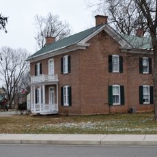
The St. Joe Lead Company Administration Building is a brick administrative structure in Bonne Terre, Missouri, completed in 1909. The two and a half-story structure features an H-shaped floor plan with pointed arch entrances and multi-colored brickwork that distinguishes its exterior.

The building was established in 1909 by the St. Joe Lead Company as its administrative headquarters and was central to the region's lead mining industry. In 1984 it was listed on the National Register of Historic Places, recognizing its importance to local history.

The building carries the name of the St. Joe Lead Company, an enterprise that shaped economic development in Bonne Terre. Visitors can see today how this structure shows that even industrial buildings were constructed with style and careful design.

The building sits near the corner of Elm Street and School Street in downtown Bonne Terre and is easy to reach. The site is not open for regular tours, but visitors interested in history can view the exterior from the street and appreciate its architectural details.

The building displays unusually stylish Gothic architecture for an industrial structure, with pointed arches and decorative brickwork that set it apart from other early factory buildings. These design features suggest the company wanted its administrative headquarters to appear impressive, even though its purpose was purely functional.

The community of curious travelers

AroundUs brings together thousands of curated places, local tips, and hidden gems, enriched daily by 60,000 contributors worldwide.

Start exploring
Location
GPS coordinates
37.92111,-90.54972
Latest update
February 9, 2026 07:40
Around this place
Elephant Rocks State Park
United States of America

Elephant Rocks State Park

32.1 km
Fort de Chartres
United States of America

Fort de Chartres

38.9 km
Hawn State Park
United States of America

Hawn State Park

29.8 km
St. Joe State Park
United States of America

St. Joe State Park

12.7 km
Washington State Park
United States of America

Washington State Park

21.7 km
Missouri Mines State Historic Site
United States of America

Missouri Mines State Historic Site

9.9 km
Fort Davidson
United States of America

Fort Davidson

33.5 km
Arcadia College
United States of America

Arcadia College

38.3 km
Kolmer Site
United States of America

Kolmer Site

37.5 km
Buford Mountain Conservation Area
United States of America

Buford Mountain Conservation Area

26.7 km
Presbyterian Orphanage of Missouri
United States of America

Presbyterian Orphanage of Missouri

18.7 km
Bootleg Access
United States of America

Bootleg Access

22.2 km
Thomas C. Fletcher House
United States of America

Thomas C. Fletcher House

34.6 km
Bonne Terre Depot
United States of America

Bonne Terre Depot

288 m
Immanuel Evangelical Lutheran Church
United States of America

Immanuel Evangelical Lutheran Church

33.8 km
St. Paul's Episcopal Church
United States of America

St. Paul's Episcopal Church

36.4 km
Pickle Springs
United States of America

Pickle Springs

25.6 km
Washington County Courthouse
United States of America

Washington County Courthouse

21 km
Central School Campus
United States of America

Central School Campus

24.1 km
Iron County Courthouse
United States of America

Iron County Courthouse

36.6 km
St. Francois County Jail and Sheriff's Residence
United States of America

St. Francois County Jail and Sheriff's Residence

19.2 km
Louis J. and Harriet Rozier House
United States of America

Louis J. and Harriet Rozier House

24.1 km
Courthouse Square Historic District
United States of America

Courthouse Square Historic District

19.4 km
East Columbia Historic District
United States of America

East Columbia Historic District

19.4 km
James Robinson McCormick House
United States of America

James Robinson McCormick House

19.1 km
Caledonia Historic District
United States of America

Caledonia Historic District

26.3 km
Harrison Queen House
United States of America

Harrison Queen House

26.9 km
Ironton Lodge Hall
United States of America

Ironton Lodge Hall

36.5 km
Show the full map
Reviews
Share your experience

No review yet

Discussions
Start a discussion...

No discussion yet

« St. Joe Lead Company Administration Building - building in Missouri, United States » is provided by Around Us (aroundus.com). Images and texts are derived from Wikimedia project under a Creative Commons license. You are allowed to copy, distribute, and modify copies of this page, under the conditions set by the license, as long as this note is clearly visible.

Discover hidden gems everywhere you go!

From secret cafés to breathtaking viewpoints, skip the crowded tourist spots and find places that match your style. Our app makes it easy with voice search, smart filtering, route optimization, and insider tips from travelers worldwide. Download now for the complete mobile experience.

Around Us App Screenshot

A unique approach to discovering new places

Le Figaro

All the places worth exploring

France Info

A tailor-made excursion in just a few clicks

20 Minutes

Around Us
Travel Guide & Maps
Download

Send to your phone

QR Code
1

Open the camera app on your mobile.

2

Point at the QR code with your camera. A notification will appear.

3

Tap the notification to open the link.