Sahul Shelf, Continental shelf in northern waters, Australia
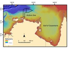
Sahul Shelf is a continental shelf that stretches across northern Australian waters toward New Guinea, lying beneath the Timor Sea and adjacent ocean areas. The platform covers roughly 120,000 square miles (310,000 square kilometers) and bears erosion patterns left by river systems that once flowed across its dry surface.
The platform stood entirely above sea level during the ice age around 18,000 years ago, connecting Australia and New Guinea as one continuous landmass. Rising waters at the end of the glacial period submerged the entire area, creating the underwater landscape visible today.
The shelf's name first appeared on Dutch maps in the 17th century, marking a submerged sandbank between Australia and Timor.
The platform descends to depths around 2,000 feet (600 meters) and consists of three main sections spanning different marine zones between Australia and Southeast Asia. Scientific expeditions regularly map the seafloor and document geological formations along the shelf edge.
Archaeologists recover stone tools and fire pits from the seafloor, evidence that humans traveled across the land bridge thousands of years ago. The submerged river valleys now provide habitats for marine species adapted to the varying depths and currents.
The community of curious travelers
AroundUs brings together thousands of curated places, local tips, and hidden gems, enriched daily by 60,000 contributors worldwide.