Wapiti Recreation Site, recreation site in Saskatchewan, Canada
Location: Torch River No. 488
GPS coordinates: 53.26101,-104.46772
Latest update: November 24, 2025 01:15
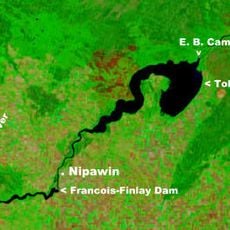
Tobin Lake
73.5 km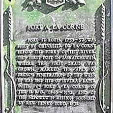
Fort de la Corne
25.4 km
Beth Israel Synagogue
23.9 km
Fort à la Corne Provincial Forest
28.7 km
Crooked Bridge
30.7 km
Nipawin Regional Park
34.4 km
Wapiti Valley Regional Park
3.1 km
Muskoday Bridge
71.5 km
Candle Lake Golf Resort
75.1 km
Maurice Street Protected Area
42.2 km
Melfort and District Regional Park
46.5 km
Birchbark Lake Recreation Site
51 km
Tisdale and District Regional Park
54 km
Pasquia Regional Park
59.7 km
Waskateena Beach Recreation Site
75.6 km
Nipawin and District Regional Park
34.4 km
Struthers Lake Regional Park
69 km
Fort-à-la-Corne Wildlife Management Unit
16.8 km
Waskateena Beach
75.2 km
Cadotte Rapids
23 km
Cole Rapids
48.8 km
Saskatchewan River Forks Recreation Site
41.2 km
Torch River Provincial Forest
41 km
Nipawin Rapids
25.9 km
Tobin Lake Recreation Site
52.6 km
Ingvald Opseth Wildlife Refuge
74.7 km
Birch Hills Golf Course
72 km
Griffin Art Mural
56.5 kmReviews
Visited this place? Tap the stars to rate it and share your experience / photos with the community! Try now! You can cancel it anytime.
Discover hidden gems everywhere you go!
From secret cafés to breathtaking viewpoints, skip the crowded tourist spots and find places that match your style. Our app makes it easy with voice search, smart filtering, route optimization, and insider tips from travelers worldwide. Download now for the complete mobile experience.

A unique approach to discovering new places❞
— Le Figaro
All the places worth exploring❞
— France Info
A tailor-made excursion in just a few clicks❞
— 20 Minutes