Enable Location

We need your location to show you interesting places around you

Discover nearby places

Find interesting locations and hidden gems around you

Precise directions

Get accurate directions and distances to places

Your location is never shared with other users. It's only used when you tap the location button.

Johannisberg

Log in to your account

Start exploring — it's free

Trusted by 63,314 travelers worldwide

Continue with Google
Continue with Apple
or

We will send you a code to connect

By continuing, you accept our Terms and Conditions and our Privacy Policy

Check your inbox

We've sent a pincode in your inbox. Please enter the code below.

Johannisberg
Discussion Reviews 1 Photos
3.3k Popularity

Johannisberg, Archaeological site and spur at Muschelkalk plateau, Germany

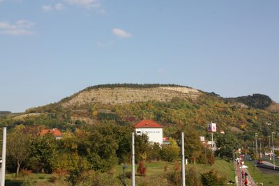
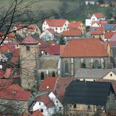
Johannisberg is a spur rising approximately 373 meters above sea level with steep slopes formed by lower Muschelkalk rock and solid limestone banks along its ridges. The plateau formation creates a naturally defensive position overlooking the Saale River valley.

The site shows continuous occupation from the Bronze Age through the early medieval period. Systematic excavations started in the 1870s by Friedrich Klopfleisch and revealed two distinct fortification phases.

The site's location on the Saale River's eastern bank bridges Frankish and Slavic cultural influences visible through recovered artifacts and remains. Visitors can observe how these two worlds met in this place.

The ridge is accessible by several hiking trails with varying difficulty levels leading to the summit. A local history path established in 1999 offers information about natural formations and the site's archaeological context.

The site is bordered by two narrow valleys: Pennickental to the north and Roda Valley to the south, creating a naturally isolated position. This geographic separation made it strategically valuable for defense across multiple cultures over thousands of years.

The community of curious travelers

AroundUs brings together thousands of curated places, local tips, and hidden gems, enriched daily by 60,000 contributors worldwide.

Start exploring
Elevation above the sea
373 m
Accessibility
Wheelchair inaccessible
GPS coordinates
50.90009,11.61163
Latest update
December 12, 2025 09:01
Reviews
Share your experience

No review yet

Discussions
Start a discussion...

No discussion yet

« Johannisberg - Archaeological site and spur at Muschelkalk plateau, Germany » is provided by Around Us (aroundus.com). Images and texts are derived from Wikimedia project under a Creative Commons license. You are allowed to copy, distribute, and modify copies of this page, under the conditions set by the license, as long as this note is clearly visible.

Discover hidden gems everywhere you go!

From secret cafés to breathtaking viewpoints, skip the crowded tourist spots and find places that match your style. Our app makes it easy with voice search, smart filtering, route optimization, and insider tips from travelers worldwide. Download now for the complete mobile experience.

Around Us App Screenshot

A unique approach to discovering new places

Le Figaro

All the places worth exploring

France Info

A tailor-made excursion in just a few clicks

20 Minutes

Around Us
Travel Guide & Maps
Download

Send to your phone

QR Code
1

Open the camera app on your mobile.

2

Point at the QR code with your camera. A notification will appear.

3

Tap the notification to open the link.