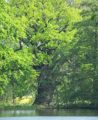
Rieseneiche von Niedergurig, Natural monument in Malschwitz, Germany.
The Rieseneiche von Niedergurig is an exceptionally large oak tree located south of Niedergurig, distinguished by its remarkable dimensions. The trunk measures roughly 10 meters (33 feet) in circumference at ground level, while the tree reaches a height of about 22 meters (72 feet).
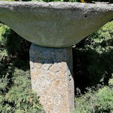
The tree is estimated to be between 700 and 800 years old, making it one of the oldest trees in the region. Around 1930, concrete filling was applied to its hollow trunk to increase structural stability.
The oak tree holds such significance for the local community that it appears on the official coat of arms of Malschwitz municipality. This symbol shows how deeply the tree is rooted in local identity.
The tree stands south of Niedergurig near the Großer Ziegelteich and is surrounded by informational signs. The site is easily accessible and provides visitors with details about the tree's dimensions and protected status.
The tree experienced an internal fire lasting several days in 2002, followed by two additional fire incidents in December 2019. Despite these severe events, the monument has demonstrated remarkable resilience.
Location: Malschwitz
GPS coordinates: 51.22130,14.48110
Latest update: December 14, 2025 13:08
Teufelsstein
2.8 km
Blücherstein Kreckwitz
1.8 km
Kirche Malschwitz
3.2 km
Schloss Malschwitz
3.3 km
Kirche Quatitz
2.7 km
Franzosenbrücke
331 m
Gefallenendenkmal Niedergurig
483 m
Steinbogenbrücke über den Mühlgraben Pließkowitzer Dorfstraße
1.8 km
Wegestein (etwa 300 m nördlich des nördlichen Ortsausgangs)
1.8 km
Lutherdenkmal Niedergurig
695 m
Wohnhaus Kreckwitz 19 (gegenüber)
2.7 km
Dahlowitz, Wegestein nach Luttowitz
2.8 km
Mord- und Sühnekreuz (etwa 300 m nördlich des nördlichen Ortsausgangs)
1.8 km
Mord- und Sühnekreuz Ahornweg (Ecke Am Staudamm)
439 m
Kreuzstein Kronförstchener Straße, gegenüber dem Wegestein
2.8 km
Kriegerdenkmal Quatitz
2.7 km
Wohnhaus Nimschützer Straße 20
2.6 km
Rittergut und Gutspark Niederkaina Niederkainaer Straße 71
3.3 km
Wegestein Niederguriger Straße 26 (bei)
891 m
Ehemalige Mühle und Wehr an der Kleinen Spree Niederguriger Straße 25
865 m
Gefallenendenkmal Briesing
1.7 km
Pfarrhaus und Gemeindehaus eines Pfarrhofes, mit Pfarrgarten und Einfriedungsmauer Dorfplatz 32
3.2 km
Obermühle; Mühlenwohnhaus einer Wassermühle mit hölzernem Übergang, Wasserrad und Mühlgraben Kleinmalschwitzer Straße 7
3.2 km
Wohnhaus und Seitengebäude eines Zweiseithofes mit Hofpflasterung Dorfplatz 10
3.3 km
Wegestein (am Ortseingang)
1.9 km
Kirchschule Dorfplatz 27
3.2 km
Kgl.-sächs. Postmeilenstein Niedergurig
996 m
Ehemaliges Wohnstallhaus eines Gehöftes Niederguriger Straße 26
914 mVisited this place? Tap the stars to rate it and share your experience / photos with the community! Try now! You can cancel it anytime.
Discover hidden gems everywhere you go!
From secret cafés to breathtaking viewpoints, skip the crowded tourist spots and find places that match your style. Our app makes it easy with voice search, smart filtering, route optimization, and insider tips from travelers worldwide. Download now for the complete mobile experience.
A unique approach to discovering new places❞
— Le Figaro
All the places worth exploring❞
— France Info
A tailor-made excursion in just a few clicks❞
— 20 Minutes