Frickenhöhle, Karst cave entrance in Farchant, Germany
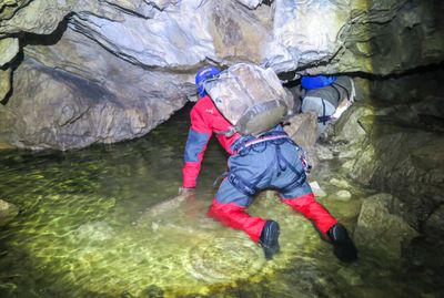
Frickenhöhle is a karst cave with a total length of 3,222 meters on the western slope of Hohen Fricken mountain near Farchant. Its interior contains large halls, branching passages, and several underground lakes distributed throughout different sections.
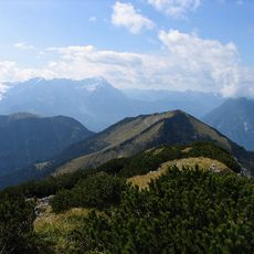
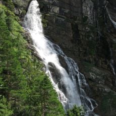
The cave formed over millions of years through water erosion in the Estergebirge region and is one of Germany's largest karst formations. Its present structure reflects the continuous work of underground water streams that shaped the passages and lakes.
The name comes from the Hohen Fricken mountain beneath which the cave extends. Today, visitors and researchers use the site to study karst formations and underground water systems.
The cave is accessible via a steep hiking trail taking about 1 hour 45 minutes from Farchant. Venturing deeper into the system requires neoprene gear or rope climbing skills to navigate water-filled sections and narrow passages.
Inside are several water-filled siphons and a vertical drop of about 60 meters between different levels. During heavy rainfall, water flows out from specific openings, revealing the active geological dynamics of the system.
Location: Farchant
GPS coordinates: 47.52978,11.14039
Latest update: December 14, 2025 11:03
Wank
2.4 km
Kuhfluchtwasserfälle
750 m
Hoher Fricken
976 m
Gasthaus zum Klos
2.2 km
Rathaus Farchant
2.3 km
Pfarrhaus Farchant
2.3 km
Kuhfluchtquelle bei Farchant
139 m
Am Gern 5
2.4 km
Getreidekasten Hauptstraße 21; Nähe Hauptstraße in Farchant
2 km
Gernweg 5
2.2 km
Bauernhaus''„Beim Noserer“''
2.4 km
Bauernhaus''„Beim Lipp“''
2.1 km
Alpspitzstraße 4
2.2 km
Bundwerk am Wirtschaftsteil und Inschrifttafel''„Beim Geiger“''
2.1 km
Ehemaliges Bauernhaus''„Beim Zach“''
2.2 km
Hauptstraße 9 (Farchant)
2.1 km
Brunngasse 3 (Farchant)
2.2 km
Esterbergstraße 19 (Farchant)
1.7 km
Ehemaliger Einhof''„Beim Gschpusi“''
2.3 km
Alpspitzstraße 1 (Farchant)
2.2 km
Wohnhaus
2 km
Ehemaliges Bauernhaus''„Beim Rieger“''
2.3 km
Ehemaliges Bauernhaus''„Beim Sternbam“''
2.3 km
Kraftvoller Zierbund''„Beim Scherer“''
2.3 km
Hauptstraße 21
2.1 km
Ehemaliger Einhof''„Beim Hessi“''
2.2 km
Bundwerk am Wirtschaftsteil''„Beim Blob“''
2.2 km
Ehemaliges Bauernhaus''„Beim Wegmacher“''
2.2 kmVisited this place? Tap the stars to rate it and share your experience / photos with the community! Try now! You can cancel it anytime.
Discover hidden gems everywhere you go!
From secret cafés to breathtaking viewpoints, skip the crowded tourist spots and find places that match your style. Our app makes it easy with voice search, smart filtering, route optimization, and insider tips from travelers worldwide. Download now for the complete mobile experience.
A unique approach to discovering new places❞
— Le Figaro
All the places worth exploring❞
— France Info
A tailor-made excursion in just a few clicks❞
— 20 Minutes