Panga Cliff, Coastal cliff in northern Saaremaa, Estonia
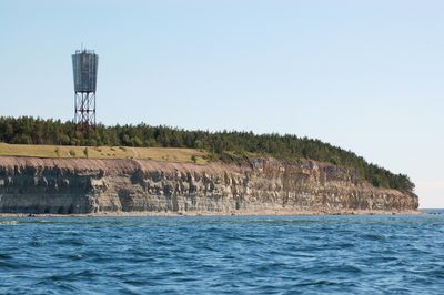
Panga Cliff is a limestone formation on the northern coast of Saaremaa island. It rises about 21 meters above the Baltic Sea and stretches for approximately 2.5 kilometers along the shoreline.
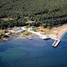
The nearby settlement of Panga was first documented in 1554 when it became a fishing center. Residents relied on coastal resources for their livelihood over the following centuries.
The name comes from the Estonian word for slope. The spring flowing from the cliff has been a gathering place for people seeking its reputed healing properties across generations.
A hiking trail runs along the cliff and provides access to various viewpoints and geological features. The path can become muddy, so sturdy footwear is recommended, especially after rain.
The cliff continues underwater and extends about 12 meters deep beneath the surface. This submerged portion makes the formation interesting from a marine geology perspective.
Location: Saaremaa Rural Municipality
Part of: Panga Peninsula, Silurian Klint
GPS coordinates: 58.57056,22.28889
Latest update: December 6, 2025 17:43
Estonia showcases limestone cliffs, medieval castle ruins, flowing waterfalls, and protected wild areas. This collection includes the Kõpu Lighthouse built in 1531 on Hiiumaa Island, the submerged stone quarries of Rummu, and numerous manor houses from the 1800s. Natural features include meteorite...
Estonia offers far more than just the capital city. Throughout the country are sandstone caves, medieval castles, and national parks that show how diverse the Baltic landscape can be. Small islands, bogs, and waterfalls tell stories of a culture deeply connected to nature. Those who travel away from...
Emmaste Church
23.1 km
Port of Sõru
19.1 km
Pidula Manor
18.5 km
Triigi Harbour
25.1 km
Saaremaa Harbour
4.9 km
Mustjala Church
12.4 km
Port de Veere
18.5 km
Sõru rear lighthouse
18.7 km
Metsküla Orthodox Church
14.1 km
Leisi Orthodox Church
23.1 km
Tärkma ohvritamm
23.4 km
Mustjala Orthodox Church
12.1 km
Panga light beacon
135 m
Võhma maalinn
5.5 km
Emmaste kalmistu
23.8 km
Abula Cliff
16.7 km
Emmaste rahvamaja
23.1 km
Tilga Nature Park
24.8 km
Küdema kurisud
12.1 km
Merise light beacon
11.9 km
Emmaste front lighthouse
20.4 km
Emmaste Library
23.4 km
Sõru kabeliaed
19.3 km
Sõru front lighthouse
18.7 km
Emmaste rear light beacon
21.2 km
Leisi Library
23 km
Mereema
19.2 km
Panga Sundial
60 mVisited this place? Tap the stars to rate it and share your experience / photos with the community! Try now! You can cancel it anytime.
Discover hidden gems everywhere you go!
From secret cafés to breathtaking viewpoints, skip the crowded tourist spots and find places that match your style. Our app makes it easy with voice search, smart filtering, route optimization, and insider tips from travelers worldwide. Download now for the complete mobile experience.
A unique approach to discovering new places❞
— Le Figaro
All the places worth exploring❞
— France Info
A tailor-made excursion in just a few clicks❞
— 20 Minutes