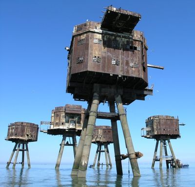
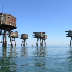
Red Sand Forts, Naval defense towers in Thames Estuary, England.
The Red Sand Forts comprise seven concrete and steel structures rising above the water of the Thames Estuary and connected by metal walkways. The towers form a military complex with multiple levels serving different functions.
The British Army built these fortifications in 1943 to protect shipping lanes against German air attacks during World War II. Equipped with anti-aircraft artillery, they served maritime defense during a critical phase of the conflict.
In the 1960s, pirate radio stations like Radio 390 broadcast from these towers and reached large audiences along the British coast. The towers became symbols of rebellion against strict radio regulations of that era.
Visiting requires a boat trip out to the estuary, so arrange tours or private providers in advance. The structures are viewable from outside, but direct approach depends on current conditions and local regulations.
The metal structures of the towers have created artificial reefs over the decades, attracting fish populations. Divers and nature enthusiasts sometimes visit the site because of these unexpected underwater habitats that have developed around the structures.
GPS coordinates: 51.46833,0.98500
Latest update: December 12, 2025 17:42
Shivering Sands Army Fort
7.1 km
Tankerton Slopes
12.2 km
Aviators Memorial
11.2 km
Sheppey Cliffs and Foreshore
9.9 km
Maplin Lighthouse
10.7 km
Tankerton Castle
12.1 km
Church of All Saints
11.2 km
Duke Of Cumberland Hotel
12.3 km
Horsebridge Centre
12.3 km
The Methodist Chapel
12.3 km
The Pearsons Arms Public House
12.3 km
Parish Church of St. Peter
12.3 km
The Ruins Of Shurland Hall Or Castle
10.7 km
16, Harbour Street
12.2 km
Tudor Restaurant
12.3 km
Slipway To West Of Royal Native Oyster Stores
12.2 km
Royal Native Oyster Stores
12.2 km
22 And 24, High Street
11 km
6 Fisherman's Stores (Rear And Side Of The Boat House)
12.2 km
Muswell Manor
9.7 km
Shellness Pillbox
11.2 km
Bell Farm Park House And Club
11.3 km
2 Stores To North East Of Sea View Bungalow
12.2 km
33, Harbour Street
12.3 km
2 Cannon (Opposite No 9)
12.1 km
25, Albert Street
12.3 km
56, Harbour Street
12.2 km
50 And 51, Harbour Street
12.2 kmVisited this place? Tap the stars to rate it and share your experience / photos with the community! Try now! You can cancel it anytime.
Discover hidden gems everywhere you go!
From secret cafés to breathtaking viewpoints, skip the crowded tourist spots and find places that match your style. Our app makes it easy with voice search, smart filtering, route optimization, and insider tips from travelers worldwide. Download now for the complete mobile experience.
A unique approach to discovering new places❞
— Le Figaro
All the places worth exploring❞
— France Info
A tailor-made excursion in just a few clicks❞
— 20 Minutes