Lincluden Collegiate Church

Log in to your account

AroundUs is a community-driven map of interesting places, built by curious explorers like you. It grows with every review, story, and photo you share.
Connect to save your favorite spots, contribute locations, and create personalized routes.
Continue with Google
Continue with Apple
Continue with X
Continue with Facebook
Continue with email
By continuing, you accept our Terms and Conditions and our Privacy Policy
Create an account

Lincluden Collegiate Church

Add to collection
Map
Suggest a change
Share

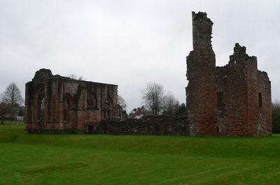
Lincluden Collegiate Church, Medieval church ruins in Dumfries, Scotland

Lincluden Collegiate Church is a ruined church standing near the confluence of Cluden Water and River Nith in Scotland, displaying Gothic architectural features and ornate stone carvings. The remains show the typical structure of a collegiate church with well-preserved elements such as pillars, arched openings, and decorative details.

The origin dates to 1160 when founded as a Benedictine nunnery by Uchtred of Galloway, before transforming into a collegiate church in 1389 under Archibald the Grim. This conversion brought architectural changes and altered the place's role in the religious community.

The name reflects the site's location at the meeting point of two waters, where visitors can still see the stone seating for priests and basins for ritual washing. This spatial arrangement reveals how the place once functioned for religious ceremonies.

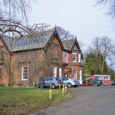
The ruins are reached on foot via a path from Cairn Circle, though directional signage is limited and good orientation helps. The site is in the open air and easily accessible, so sturdy footwear is recommended, especially in damp weather.

The east window was created by French master mason John Morrow, whose design echoes that of Paisley Abbey and reveals medieval Scottish-French artistic connections. This detail shows the international artistic networks that were active even in remote regions during the Middle Ages.

Location: Dumfries and Galloway

Location: Terregles

Inception: 12 century

GPS coordinates: 55.08519,-3.62063

Latest update: December 12, 2025 09:06

Photos
Around this place
Moat Brae
United Kingdom

Moat Brae

1.6 km
Dumfries, Church Crescent, Greyfriars Church
United Kingdom

Dumfries, Church Crescent, Greyfriars Church

1.7 km
Gracefield Arts Centre
United Kingdom

Gracefield Arts Centre

1.5 km
Loreburn Hall
United Kingdom

Loreburn Hall

1.9 km
Nithsdale District Council Offices, Dumfries
United Kingdom

Nithsdale District Council Offices, Dumfries

1.7 km
Dumfries, 81, 83 Buccleuch Street, Methodist Church
United Kingdom

Dumfries, 81, 83 Buccleuch Street, Methodist Church

1.7 km
Queensberry Monument
United Kingdom

Queensberry Monument

1.9 km
Statue of Robert Burns
United Kingdom

Statue of Robert Burns

1.8 km
Dumfries, Glasgow Street, St Teresa's R.C. Church
United Kingdom

Dumfries, Glasgow Street, St Teresa's R.C. Church

1.4 km
Queen of the South Viaduct
United Kingdom

Queen of the South Viaduct

783 m
Martinton Bridge
United Kingdom

Martinton Bridge

700 m
Dumfries Station, Footbridge
United Kingdom

Dumfries Station, Footbridge

1.7 km
Dumfries, 128 Queensberry Street, Paling's
United Kingdom

Dumfries, 128 Queensberry Street, Paling's

1.7 km
142 Queensberry Street, Dumfries
United Kingdom

142 Queensberry Street, Dumfries

1.7 km
Dumfries, Station Road, Station Hotel
United Kingdom

Dumfries, Station Road, Station Hotel

1.8 km
Dumfries, 40 Buccleuch Street, Sheriff Court House
United Kingdom

Dumfries, 40 Buccleuch Street, Sheriff Court House

1.8 km
Buccleuch Street Bridge
United Kingdom

Buccleuch Street Bridge

1.8 km
Dumfries, Academy Street, Dumfries Academy
United Kingdom

Dumfries, Academy Street, Dumfries Academy

1.6 km
Dumfries, 3, 4 Galloway Street, Clydesdale Bank
United Kingdom

Dumfries, 3, 4 Galloway Street, Clydesdale Bank

1.8 km
46 Galloway Street, Dumfries
United Kingdom

46 Galloway Street, Dumfries

1.8 km
Dumfries, 7 Church Place
United Kingdom

Dumfries, 7 Church Place

1.8 km
Dumfries, 1, 2 Galloway Street
United Kingdom

Dumfries, 1, 2 Galloway Street

1.8 km
Dumfries, 13-19 Glasgow Street
United Kingdom

Dumfries, 13-19 Glasgow Street

1.8 km
Dumfries, George Street, St Michael's Lodge
United Kingdom

Dumfries, George Street, St Michael's Lodge

1.7 km
43, 44 Galloway Street, Dumfries
United Kingdom

43, 44 Galloway Street, Dumfries

1.8 km
45 Galloway Street, Dumfries
United Kingdom

45 Galloway Street, Dumfries

1.8 km
Dumfries Station, East Platform Range
United Kingdom

Dumfries Station, East Platform Range

1.8 km
Dumfries, 1 Glasgow Street
United Kingdom

Dumfries, 1 Glasgow Street

1.8 km
Show the full map
Reviews

Visited this place? Tap the stars to rate it and share your experience / photos with the community! Try now! You can cancel it anytime.

« Lincluden Collegiate Church - Medieval church ruins in Dumfries, Scotland » is provided by Around Us (aroundus.com). Images and texts are derived from Wikimedia project under a Creative Commons license. You are allowed to copy, distribute, and modify copies of this page, under the conditions set by the license, as long as this note is clearly visible.

Discover hidden gems everywhere you go!

From secret cafés to breathtaking viewpoints, skip the crowded tourist spots and find places that match your style. Our app makes it easy with voice search, smart filtering, route optimization, and insider tips from travelers worldwide. Download now for the complete mobile experience.

Around Us App Screenshot

A unique approach to discovering new places

Le Figaro

All the places worth exploring

France Info

A tailor-made excursion in just a few clicks

20 Minutes