Enable Location

We need your location to show you interesting places around you

Discover nearby places

Find interesting locations and hidden gems around you

Precise directions

Get accurate directions and distances to places

Your location is never shared with other users. It's only used when you tap the location button.

Kilburn White Horse

Log in to your account

Start exploring — it's free

Trusted by 62,539 travelers worldwide

Continue with Google
Continue with Apple
or

We will send you a code to connect

By continuing, you accept our Terms and Conditions and our Privacy Policy

Check your inbox

We've sent a pincode in your inbox. Please enter the code below.

Kilburn White Horse

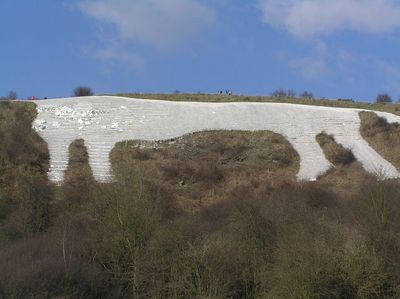
Kilburn White Horse, Hill figure in North Yorkshire, England.

Kilburn White Horse is a large horse figure carved into the southern slope of Sutton Bank. The figure spans a substantial hillside and is visible from considerable distance when approaching the ridge from various directions.

A local businessman commissioned the figure in 1857, and many workers extracted limestone from the hillside to create it. During the Second World War, it was darkened to prevent enemy aircraft from using it as a navigation landmark.

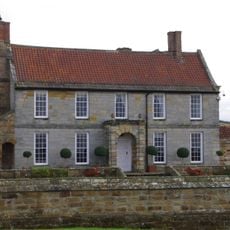
The horse has been a landmark that brings people to this hillside to view it from multiple vantage points across the valley. Locals and visitors alike recognize it as a symbol of the region and a place worth visiting repeatedly.

Two parking areas sit along Sutton Bank Road, each offering good viewing opportunities and access to the hillside. The upper areas can be exposed to wind on blustery days, so layered clothing is wise.

The horse is not made of chalk but from a different stone that must be regularly maintained to stay white. This characteristic requires ongoing care and attention from those who look after it.

The community of curious travelers

AroundUs brings together thousands of curated places, local tips, and hidden gems, enriched daily by 60,000 contributors worldwide.

Start exploring
Location
GPS coordinates
54.22479,-1.21274
Latest update
December 20, 2025 15:41
Around this place
Stanbrook Abbey
United Kingdom

Stanbrook Abbey

4.3 km
Byland Abbey
United Kingdom

Byland Abbey

4.1 km
Newburgh Priory
United Kingdom

Newburgh Priory

5.6 km
Shandy Hall
United Kingdom

Shandy Hall

4.4 km
Church of St Michael, Coxwold
United Kingdom

Church of St Michael, Coxwold

4.5 km
Church of St Felix
United Kingdom

Church of St Felix

5.8 km
Church of St Mary
United Kingdom

Church of St Mary

4.8 km
Church of St Mary
United Kingdom

Church of St Mary

1.6 km
Church of St Mary
United Kingdom

Church of St Mary

5.1 km
Church of Saint Mary
United Kingdom

Church of Saint Mary

4.2 km
Church of All Saints, Great Thirkleby
United Kingdom

Church of All Saints, Great Thirkleby

4.8 km
The Abbey Inn
United Kingdom

The Abbey Inn

4.1 km
War Memorial Set in Wall Approximately 7 Metres to South of Churchyard South Gateway
United Kingdom

War Memorial Set in Wall Approximately 7 Metres to South of Churchyard South Gateway

1.7 km
Bridge Over Gurtoff Beck
United Kingdom

Bridge Over Gurtoff Beck

5.8 km
Coxwold War Memorial Within The Churchyard Of Saint Michael's Church
United Kingdom

Coxwold War Memorial Within The Churchyard Of Saint Michael's Church

4.5 km
Hood Grange Farmhouse
United Kingdom

Hood Grange Farmhouse

1.4 km
Wayside cross known as Cooper Cross on Sutton Bank
United Kingdom

Wayside cross known as Cooper Cross on Sutton Bank

1.7 km
Thatch Cottage
United Kingdom

Thatch Cottage

4.9 km
Front Garden Wall With Gate Piers At Osgodby Hall
United Kingdom

Front Garden Wall With Gate Piers At Osgodby Hall

2.2 km
Milepost Approximately 150 Metres East Of Spring Cottage And Greystones
United Kingdom

Milepost Approximately 150 Metres East Of Spring Cottage And Greystones

2.3 km
Osgodby Hall
United Kingdom

Osgodby Hall

2.2 km
Milepost Approximately 30 Metres South Of High Lodge
United Kingdom

Milepost Approximately 30 Metres South Of High Lodge

4.5 km
Milepost Approximately 225 Metres To West Of Track To Gormire Lake
United Kingdom

Milepost Approximately 225 Metres To West Of Track To Gormire Lake

1.5 km
Milepost Approximately 170 Metres To East Of Drive To Whitestone Gardens
United Kingdom

Milepost Approximately 170 Metres To East Of Drive To Whitestone Gardens

2.6 km
Former School
United Kingdom

Former School

1.7 km
Mounting Block Approximately 6 Metres To South West Of South Gate To Church Of St Mary
United Kingdom

Mounting Block Approximately 6 Metres To South West Of South Gate To Church Of St Mary

1.7 km
Wayside cross base on south side of the churchyard wall at Scawton
United Kingdom

Wayside cross base on south side of the churchyard wall at Scawton

4.1 km
Milestone, top of Sutton Bank
United Kingdom

Milestone, top of Sutton Bank

1.7 km
Show the full map
« Kilburn White Horse - Hill figure in North Yorkshire, England » is provided by Around Us (aroundus.com). Images and texts are derived from Wikimedia project under a Creative Commons license. You are allowed to copy, distribute, and modify copies of this page, under the conditions set by the license, as long as this note is clearly visible.

Discover hidden gems everywhere you go!

From secret cafés to breathtaking viewpoints, skip the crowded tourist spots and find places that match your style. Our app makes it easy with voice search, smart filtering, route optimization, and insider tips from travelers worldwide. Download now for the complete mobile experience.

Around Us App Screenshot

A unique approach to discovering new places

Le Figaro

All the places worth exploring

France Info

A tailor-made excursion in just a few clicks

20 Minutes

Around Us
Travel Guide & Maps
Download

Send to your phone

QR Code
1

Open the camera app on your mobile.

2

Point at the QR code with your camera. A notification will appear.

3

Tap the notification to open the link.