Enable Location

We need your location to show you interesting places around you

Discover nearby places

Find interesting locations and hidden gems around you

Precise directions

Get accurate directions and distances to places

Your location is never shared with other users. It's only used when you tap the location button.

Aqualate Hall

Log in to your account

Start exploring — it's free

Trusted by 62,519 travelers worldwide

Continue with Google
Continue with Apple
or

We will send you a code to connect

By continuing, you accept our Terms and Conditions and our Privacy Policy

Check your inbox

We've sent a pincode in your inbox. Please enter the code below.

Aqualate Hall

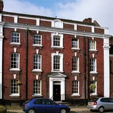
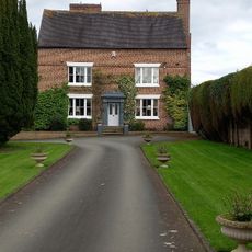
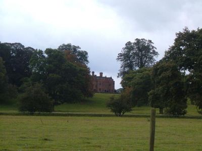
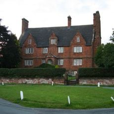
Aqualate Hall, Grade II* listed building in Forton, England.

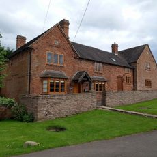
Aqualate Hall is a red brick country house in the Midlands featuring a distinctive two-storey polygonal porch and projecting canted bays with armorial shields on its north front. The structure has clay tile roofs that give it a traditional English country house character.

The original manor house from the 16th century underwent a Gothic redesign by architect John Nash in 1808. A major fire in 1910 damaged much of the structure, leading to significant rebuilding efforts.

The name Aqualate comes from Latin words meaning water, referencing the lakes surrounding the estate that shaped its character. This connection to the landscape remains visible in how the house relates to its natural setting today.

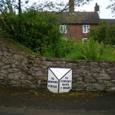
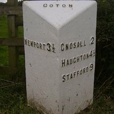
The estate sits roughly 2 miles east of Newport and about 10 miles west of Stafford in the Midlands region. Since it remains a private residence, visitors cannot enter the house or grounds at any time during the year.

During World War II the grounds became a military transport base where Nissen huts were erected for wartime operations. After the war these temporary structures provided shelter for homeless people until the early 1950s.

The community of curious travelers

AroundUs brings together thousands of curated places, local tips, and hidden gems, enriched daily by 60,000 contributors worldwide.

Start exploring
Location
GPS coordinates
52.77450,-2.33716
Latest update
December 12, 2025 12:07
Around this place
The Royal Victoria Hotel
United Kingdom

The Royal Victoria Hotel

2.9 km
St Peter and Paul Church, Newport
United Kingdom

St Peter and Paul Church, Newport

3.2 km
St Nicholas Church
United Kingdom

St Nicholas Church

2.9 km
Forton Hall
United Kingdom

Forton Hall

2.4 km
Newport Guildhall
United Kingdom

Newport Guildhall

2.9 km
Butter Cross
United Kingdom

Butter Cross

2.9 km
Former Town Hall [Owners Newport (Salop) Market And Trading Company]
United Kingdom

Former Town Hall [Owners Newport (Salop) Market And Trading Company]

2.8 km
Church of St. Andrew
United Kingdom

Church of St. Andrew

3.5 km
Church of All Saints
United Kingdom

Church of All Saints

2.4 km
Newport War Memorial, Shropshire
United Kingdom

Newport War Memorial, Shropshire

2.9 km
St Mary
United Kingdom

St Mary

3.4 km
Shropshire Union Canal Barn Bridge (Number 37) At Sj 809 211
United Kingdom

Shropshire Union Canal Barn Bridge (Number 37) At Sj 809 211

3.8 km
Beaumaris House
United Kingdom

Beaumaris House

3 km
Roving bridge and lock called Newport Lock 255m south east of Wrekin View Farm
United Kingdom

Roving bridge and lock called Newport Lock 255m south east of Wrekin View Farm

3 km
The Almshouses
United Kingdom

The Almshouses

2.6 km
Milepost Shropshire Union Canal 1.5 Miles To South Of Norbury Junction
United Kingdom

Milepost Shropshire Union Canal 1.5 Miles To South Of Norbury Junction

3.9 km
Upper Farmhouse
United Kingdom

Upper Farmhouse

2.9 km
Aston Manor
United Kingdom

Aston Manor

2.8 km
130, High Street
United Kingdom

130, High Street

3 km
Central Block (Adams' Grammar School)
United Kingdom

Central Block (Adams' Grammar School)

3.1 km
Newport Branch Canal Basin Bridge (Number 1) Norbury Junction At Sj 792 227
United Kingdom

Newport Branch Canal Basin Bridge (Number 1) Norbury Junction At Sj 792 227

3.7 km
Milepost Shropshire Union Canal 0.5 Miles To South Of Norbury Junction
United Kingdom

Milepost Shropshire Union Canal 0.5 Miles To South Of Norbury Junction

3.3 km
Milestone, by No. 130 High Street, opposite Beaumaris House
United Kingdom

Milestone, by No. 130 High Street, opposite Beaumaris House

2.9 km
Milestone, Chetwynd Park; opp. Middle Lodge
United Kingdom

Milestone, Chetwynd Park; opp. Middle Lodge

3.4 km
Milepost, Pave Lane; by No. 58
United Kingdom

Milepost, Pave Lane; by No. 58

3.4 km
28
United Kingdom

28

2.8 km
Milepost, Coton
United Kingdom

Milepost, Coton

2.8 km
Milepost, just S turn to Oulton House
United Kingdom

Milepost, just S turn to Oulton House

3.3 km
Show the full map
« Aqualate Hall - Grade II* listed building in Forton, England » is provided by Around Us (aroundus.com). Images and texts are derived from Wikimedia project under a Creative Commons license. You are allowed to copy, distribute, and modify copies of this page, under the conditions set by the license, as long as this note is clearly visible.

Discover hidden gems everywhere you go!

From secret cafés to breathtaking viewpoints, skip the crowded tourist spots and find places that match your style. Our app makes it easy with voice search, smart filtering, route optimization, and insider tips from travelers worldwide. Download now for the complete mobile experience.

Around Us App Screenshot

A unique approach to discovering new places

Le Figaro

All the places worth exploring

France Info

A tailor-made excursion in just a few clicks

20 Minutes

Around Us
Travel Guide & Maps
Download

Send to your phone

QR Code
1

Open the camera app on your mobile.

2

Point at the QR code with your camera. A notification will appear.

3

Tap the notification to open the link.