Enable Location

We need your location to show you interesting places around you

Discover nearby places

Find interesting locations and hidden gems around you

Precise directions

Get accurate directions and distances to places

Your location is never shared with other users. It's only used when you tap the location button.

Beckfoot Bridge

Log in to your account

Start exploring — it's free

Trusted by 62,467 travelers worldwide

Continue with Google
Continue with Apple
or

We will send you a code to connect

By continuing, you accept our Terms and Conditions and our Privacy Policy

Check your inbox

We've sent a pincode in your inbox. Please enter the code below.

Beckfoot Bridge

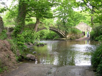
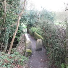
Beckfoot Bridge, Grade II listed packhorse bridge in Bingley, England

Beckfoot Bridge is an 18th century stone packhorse bridge that spans Harden Beck with a single arch designed to let water flow freely below. The structure has a narrow form built only for single-file foot traffic and links walking routes in the area.

The structure was built in 1723 replacing an older wooden bridge that once crossed this spot. Two contractors were paid for construction and took on responsibility for its upkeep.

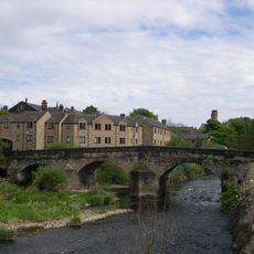
The bridge was part of an old trading system that moved goods across Yorkshire and shows how people once used their landscape for commerce. Visitors can still see how such structures shaped daily life across the entire region.

The narrow passage allows only one person to cross at a time, so visitors should allow time for crossing especially when others are present. The bridge sits on a popular walking route and is easily reached from nearby footpaths.

The bridge sits near Beckfoot Farm and Goit Stock Wood, where the waters once powered several local mills. This location shows how water power and transportation routes were closely linked in the past.

The community of curious travelers

AroundUs brings together thousands of curated places, local tips, and hidden gems, enriched daily by 60,000 contributors worldwide.

Start exploring
Location
GPS coordinates
53.84221,-1.84183
Latest update
December 13, 2025 11:42
Around this place
Bingley St Ives
United Kingdom

Bingley St Ives

1.3 km
Ireland Bridge
United Kingdom

Ireland Bridge

900 m
Bingley Three Rise Locks
United Kingdom

Bingley Three Rise Locks

1 km
Old White Horse Inn
United Kingdom

Old White Horse Inn

928 m
Holy Trinity Church, Bingley
United Kingdom

Holy Trinity Church, Bingley

830 m
Church of All Saints, Bingley
United Kingdom

Church of All Saints, Bingley

1 km
Myrtle Grove
United Kingdom

Myrtle Grove

507 m
Bingley Independent Methodist Church
United Kingdom

Bingley Independent Methodist Church

809 m
Bingley Baptist Church
United Kingdom

Bingley Baptist Church

1 km
Bingley Library
United Kingdom

Bingley Library

690 m
Leeds And Liverpool Canal Scourer Bridge (Number 205)
United Kingdom

Leeds And Liverpool Canal Scourer Bridge (Number 205)

1.3 km
Leeds And Liverpool Canal Two Rise Locks With Overflow Channel Dowley Gap
United Kingdom

Leeds And Liverpool Canal Two Rise Locks With Overflow Channel Dowley Gap

1.5 km
Bingley War Memorial
United Kingdom

Bingley War Memorial

428 m
Butter Cross At The Old Market Hall
United Kingdom

Butter Cross At The Old Market Hall

663 m
Footbridge At Beckfoot Approximately 5 Metres To South Of Mill Cottage
United Kingdom

Footbridge At Beckfoot Approximately 5 Metres To South Of Mill Cottage

158 m
Bingley Arts Centre
United Kingdom

Bingley Arts Centre

659 m
Bowling Green Mill Engine House And Attached Chimney Occupied By Damart
United Kingdom

Bowling Green Mill Engine House And Attached Chimney Occupied By Damart

1 km
Holy Trinity Church of England First School
United Kingdom

Holy Trinity Church of England First School

863 m
Former Library Premises
United Kingdom

Former Library Premises

709 m
St Davids Ruin
United Kingdom

St Davids Ruin

1.3 km
St Ives Mansion House
United Kingdom

St Ives Mansion House

1.3 km
The Stable Block Used By Turf Research Institute
United Kingdom

The Stable Block Used By Turf Research Institute

1.2 km
Bingley Church Of England First School
United Kingdom

Bingley Church Of England First School

929 m
Old Market Hall
United Kingdom

Old Market Hall

673 m
Band Stand
United Kingdom

Band Stand

505 m
Bettys Lodge
United Kingdom

Bettys Lodge

846 m
Old Railway Shed Depot, Approximately 30 Metres South East Of New Fire Station
United Kingdom

Old Railway Shed Depot, Approximately 30 Metres South East Of New Fire Station

941 m
Stocks At The Old Market Hall
United Kingdom

Stocks At The Old Market Hall

660 m
Show the full map
« Beckfoot Bridge - Grade II listed packhorse bridge in Bingley, England » is provided by Around Us (aroundus.com). Images and texts are derived from Wikimedia project under a Creative Commons license. You are allowed to copy, distribute, and modify copies of this page, under the conditions set by the license, as long as this note is clearly visible.

Discover hidden gems everywhere you go!

From secret cafés to breathtaking viewpoints, skip the crowded tourist spots and find places that match your style. Our app makes it easy with voice search, smart filtering, route optimization, and insider tips from travelers worldwide. Download now for the complete mobile experience.

Around Us App Screenshot

A unique approach to discovering new places

Le Figaro

All the places worth exploring

France Info

A tailor-made excursion in just a few clicks

20 Minutes

Around Us
Travel Guide & Maps
Download

Send to your phone

QR Code
1

Open the camera app on your mobile.

2

Point at the QR code with your camera. A notification will appear.

3

Tap the notification to open the link.