Enable Location

We need your location to show you interesting places around you

Discover nearby places

Find interesting locations and hidden gems around you

Precise directions

Get accurate directions and distances to places

Your location is never shared with other users. It's only used when you tap the location button.

Clouds House

Log in to your account

Start exploring — it's free

Trusted by 63,021 travelers worldwide

Continue with Google
Continue with Apple
or

We will send you a code to connect

By continuing, you accept our Terms and Conditions and our Privacy Policy

Check your inbox

We've sent a pincode in your inbox. Please enter the code below.

Clouds House
Discussion Reviews 1 Photos
12k Popularity

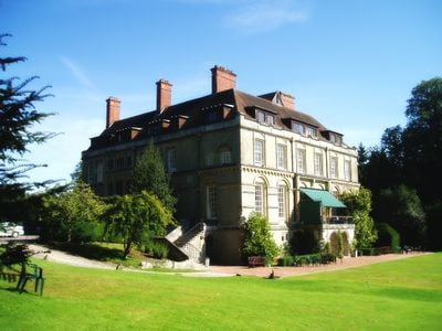
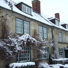
Clouds House, Grade II listed house in East Knoyle, England.

Clouds House is a two-storey stone building with an attic level, featuring a hipped tile roof, brick chimneys, and multiple sash windows with eighteen panes. The exterior shows careful construction with rendered stonework and traditional window proportions.

Architect Philip Webb designed and built the house between 1881 and 1891 for Percy Wyndham. The structure was completely rebuilt after a fire in 1889 during its initial construction.

The building served as a meeting place for The Souls, a group of late Victorian artists and politicians who gathered here regularly. The spaces still reflect the refined taste of those who once used them for intellectual exchange.

The building now operates as a residential treatment center for addiction recovery, run by a specialized organization. Access may be limited as it remains an active treatment facility with residents.

The interior retains original carved roof trusses, open-well stairs, ornate plasterwork, and period fireplaces with detailed paneling. These crafted elements showcase the quality of late-century construction.

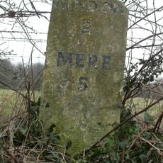
The community of curious travelers

AroundUs brings together thousands of curated places, local tips, and hidden gems, enriched daily by 60,000 contributors worldwide.

Start exploring
Location
Architects
Philip Webb
GPS coordinates
51.07890,-2.17722
Latest update
December 7, 2025 20:47
Around this place
Fonthill Abbey
United Kingdom

Fonthill Abbey

4.1 km
Pythouse
United Kingdom

Pythouse

3.9 km
East Knoyle War Memorial
United Kingdom

East Knoyle War Memorial

701 m
St Leonard's Church, Berwick St Leonard
United Kingdom

St Leonard's Church, Berwick St Leonard

5.1 km
Church of St Mary
United Kingdom

Church of St Mary

643 m
Church of St John the Baptist
United Kingdom

Church of St John the Baptist

3.8 km
Church of St Leonard
United Kingdom

Church of St Leonard

4.5 km
Church of St Katherine
United Kingdom

Church of St Katherine

3 km
Church of All Saints
United Kingdom

Church of All Saints

5 km
Church of St Mary the Virgin
United Kingdom

Church of St Mary the Virgin

2.4 km
Hindon War Memorial
United Kingdom

Hindon War Memorial

3.8 km
Milestone About 200 Metres East Of Junction With Upton Lane
United Kingdom

Milestone About 200 Metres East Of Junction With Upton Lane

2.4 km
The Lamb Inn
United Kingdom

The Lamb Inn

3.8 km
Milestone On Ridgeway Track At Ngr 847343
United Kingdom

Milestone On Ridgeway Track At Ngr 847343

4.4 km
Milestone About 200 Metres North Of Junction With Street Lane
United Kingdom

Milestone About 200 Metres North Of Junction With Street Lane

3.2 km
Milestone About 500 Metres East Of Willoughby Hedge
United Kingdom

Milestone About 500 Metres East Of Willoughby Hedge

2.8 km
Windmill
United Kingdom

Windmill

340 m
Milestone About 175 Metres South West Of The Grosvenor Arms
United Kingdom

Milestone About 175 Metres South West Of The Grosvenor Arms

3.6 km
Guide Post Opposite North West Entrance To Churchyard Of Church Of St Leonard
United Kingdom

Guide Post Opposite North West Entrance To Churchyard Of Church Of St Leonard

4.4 km
Milestone About 100 Metres North East Of Kemps Barn
United Kingdom

Milestone About 100 Metres North East Of Kemps Barn

2.6 km
Milestone About 50 Metres South Of St Denys
United Kingdom

Milestone About 50 Metres South Of St Denys

2 km
Milepost About 125 Metres North Of Junction With Lane To Miltion
United Kingdom

Milepost About 125 Metres North Of Junction With Lane To Miltion

1.3 km
Milestone At Ngr 838328
United Kingdom

Milestone At Ngr 838328

4.2 km
Milestone, Hindon Road; 200m E entrance Berwick Farm
United Kingdom

Milestone, Hindon Road; 200m E entrance Berwick Farm

5.1 km
Milestone, Keysley Down; 150m E entrance Keysley Farm
United Kingdom

Milestone, Keysley Down; 150m E entrance Keysley Farm

2.8 km
Milestone, Chaddenwick Hill
United Kingdom

Milestone, Chaddenwick Hill

3.7 km
Milestone, Willoughby Hedge; 500m E lay-by & snack bar
United Kingdom

Milestone, Willoughby Hedge; 500m E lay-by & snack bar

2.7 km
Milestone, Hindon Road
United Kingdom

Milestone, Hindon Road

695 m
Show the full map
Reviews
Share your experience

No review yet

Discussions
Start a discussion...

No discussion yet

« Clouds House - Grade II listed house in East Knoyle, England » is provided by Around Us (aroundus.com). Images and texts are derived from Wikimedia project under a Creative Commons license. You are allowed to copy, distribute, and modify copies of this page, under the conditions set by the license, as long as this note is clearly visible.

Discover hidden gems everywhere you go!

From secret cafés to breathtaking viewpoints, skip the crowded tourist spots and find places that match your style. Our app makes it easy with voice search, smart filtering, route optimization, and insider tips from travelers worldwide. Download now for the complete mobile experience.

Around Us App Screenshot

A unique approach to discovering new places

Le Figaro

All the places worth exploring

France Info

A tailor-made excursion in just a few clicks

20 Minutes

Around Us
Travel Guide & Maps
Download

Send to your phone

QR Code
1

Open the camera app on your mobile.

2

Point at the QR code with your camera. A notification will appear.

3

Tap the notification to open the link.