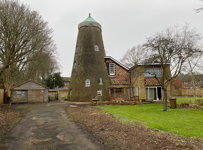
Croxley Green Windmill, Grade II listed tower mill in Croxley Green, England.
Croxley Green Windmill is a five-story tower mill with a circular stone structure that rises distinctly against the Hertfordshire skyline. The building was converted to residential use in the 1960s while retaining its recognizable form in the center of the village.
The mill was built around 1860 and initially operated with four patent sails and a boat-shaped cap. Strong winds damaged the sails in the 1880s, prompting a switch to steam power.
The site shifted from grain processing to sawmill operations and served as an air raid observation post during World War II. This transformation shows how the building adapted to meet the needs of different eras.
The building is privately owned today and can be viewed from outside, with its distinctive form visible from various angles in the immediate area. A clear day provides the best view when the stone walls and overall shape stand out most clearly.
Three pairs of millstones operated simultaneously during commercial production, which was unusually efficient for a mill of this size. Notable millers including Isaac Watts, Philip Howard, and Hannah Holloway managed these operations across different decades.
Location: Croxley Green
GPS coordinates: 51.64638,-0.45803
Latest update: December 13, 2025 12:25
Croxley Common Moor
1.6 km
The Withey Beds
1.6 km
Batchworth Heath
1.6 km
War Memorial About 40 Metres East of Church of St Mary
1.2 km
Church of St Mary, Rickmansworth
1.3 km
Church of All Saints
192 m
War Memorial Statue
1.1 km
7 and 9, Church Street
1.2 km
25 and 27, Church Street
1.2 km
K6 Telephone Kiosk Outside St Mary's Church
1.3 km
The Coach And Horses Public House
972 m
99, Church Street
1.4 km
53-61, Church Street
1.2 km
29 and 31, Church Street
1.2 km
The Fox And Hounds Public House
1.3 km
The Feathers Public House
1.3 km
Wilson Monument Immediately North Of Chancel Of Church Of St Mary
1.3 km
Roman Catholic Church of Our Lady Help of Christians and St Augustine's Hall
716 m
Obelisk On South Bank In Garden Of Number 17 Moor Lane
1.3 km
The Old Vicarage
1.2 km
The Priory
1.3 km
Redheath
1.8 km
The Chequers Restaurant
1.2 km
Pair Of Chest Tombs With Fluted Corner Piers About 10 Metres North Of Church Of St Mary
1.3 km
The Bury
1.3 km
72, 72A And 72B, High Street
1.2 km
17, Moor Lane
1.3 km
21 And 25, Harefield Road
1.6 kmVisited this place? Tap the stars to rate it and share your experience / photos with the community! Try now! You can cancel it anytime.
Discover hidden gems everywhere you go!
From secret cafés to breathtaking viewpoints, skip the crowded tourist spots and find places that match your style. Our app makes it easy with voice search, smart filtering, route optimization, and insider tips from travelers worldwide. Download now for the complete mobile experience.
A unique approach to discovering new places❞
— Le Figaro
All the places worth exploring❞
— France Info
A tailor-made excursion in just a few clicks❞
— 20 Minutes