Croxley Common Moor

Log in to your account

AroundUs is a community-driven map of interesting places, built by curious explorers like you. It grows with every review, story, and photo you share.
Connect to save your favorite spots, contribute locations, and create personalized routes.
By continuing, you accept our Terms and Conditions and our Privacy Policy
Add to collection
Map
Suggest a change
Share

Croxley Common Moor, Nature reserve and scientific interest site in Hertfordshire, England

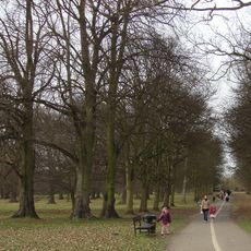
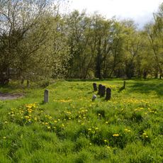
Croxley Common Moor is a protected grassland site covering around 40 hectares in Hertfordshire with gently rolling terrain. The reserve hosts more than 250 plant species such as sheep sorrel, common bent, and sheep's fescue scattered across its varied landscape.

The site was shaped over centuries by agricultural use, where traditional grazing methods maintained its natural character and plant diversity. This long-standing land management approach preserved the ecological balance that exists today.

Three Rivers District Council collaborates with local organizations and community volunteers to manage and preserve the natural environment.

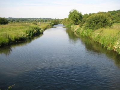
Access to the site is possible via the Ebury Way walking and cycling route or through a footbridge over the River Gade near Croxley tube station. Visitors will find several entry points that make it convenient to explore the reserve on foot.

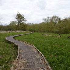
The grassland features numerous ant hills created by yellow meadow ants, which give the ground a distinctive bumpy texture across the site. These natural formations are a key part of what makes the landscape visually distinctive to those who explore it closely.

Location: Hertfordshire

GPS coordinates: 51.64250,-0.43628

Latest update: December 14, 2025 17:43

Photos
Around this place
Moor Park
United Kingdom

Moor Park

1.8 km
Cassiobury Park
United Kingdom

Cassiobury Park

2.3 km
Croxley Green Windmill
United Kingdom

Croxley Green Windmill

1.6 km
The Lairage Land
United Kingdom

The Lairage Land

2.1 km
The Withey Beds
United Kingdom

The Withey Beds

1 km
Batchworth Heath
United Kingdom

Batchworth Heath

1 km
War Memorial About 40 Metres East of Church of St Mary
United Kingdom

War Memorial About 40 Metres East of Church of St Mary

2.2 km
Church of St Mary, Rickmansworth
United Kingdom

Church of St Mary, Rickmansworth

2.3 km
Church of All Saints
United Kingdom

Church of All Saints

1.4 km
The Coach And Horses Public House
United Kingdom

The Coach And Horses Public House

2.1 km
7 and 9, Church Street
United Kingdom

7 and 9, Church Street

2.3 km
War Memorial Statue
United Kingdom

War Memorial Statue

2.3 km
K6 Telephone Kiosk Outside St Mary's Church
United Kingdom

K6 Telephone Kiosk Outside St Mary's Church

2.2 km
25 and 27, Church Street
United Kingdom

25 and 27, Church Street

2.3 km
99, Church Street
United Kingdom

99, Church Street

2.3 km
53-61, Church Street
United Kingdom

53-61, Church Street

2.2 km
29 and 31, Church Street
United Kingdom

29 and 31, Church Street

2.3 km
The Feathers Public House
United Kingdom

The Feathers Public House

2.3 km
Wilson Monument Immediately North Of Chancel Of Church Of St Mary
United Kingdom

Wilson Monument Immediately North Of Chancel Of Church Of St Mary

2.3 km
Roman Catholic Church of Our Lady Help of Christians and St Augustine's Hall
United Kingdom

Roman Catholic Church of Our Lady Help of Christians and St Augustine's Hall

2.1 km
The Chequers Restaurant
United Kingdom

The Chequers Restaurant

2.3 km
The Old Vicarage
United Kingdom

The Old Vicarage

2.3 km
Obelisk On South Bank In Garden Of Number 17 Moor Lane
United Kingdom

Obelisk On South Bank In Garden Of Number 17 Moor Lane

2 km
The Priory
United Kingdom

The Priory

2.3 km
Pair Of Chest Tombs With Fluted Corner Piers About 10 Metres North Of Church Of St Mary
United Kingdom

Pair Of Chest Tombs With Fluted Corner Piers About 10 Metres North Of Church Of St Mary

2.3 km
Milestone About 35 Metres West Of Number 1 Home Farm Road (Not Listed)
United Kingdom

Milestone About 35 Metres West Of Number 1 Home Farm Road (Not Listed)

2.4 km
17, Moor Lane
United Kingdom

17, Moor Lane

2 km
Cassio Bridge Lock Number 78
United Kingdom

Cassio Bridge Lock Number 78

1.4 km
Show the full map
Reviews

Visited this place? Tap the stars to rate it and share your experience / photos with the community! Try now! You can cancel it anytime.

« Croxley Common Moor - Nature reserve and scientific interest site in Hertfordshire, England » is provided by Around Us (aroundus.com). Images and texts are derived from Wikimedia project under a Creative Commons license. You are allowed to copy, distribute, and modify copies of this page, under the conditions set by the license, as long as this note is clearly visible.

Discover hidden gems everywhere you go!

From secret cafés to breathtaking viewpoints, skip the crowded tourist spots and find places that match your style. Our app makes it easy with voice search, smart filtering, route optimization, and insider tips from travelers worldwide. Download now for the complete mobile experience.

Around Us App Screenshot

A unique approach to discovering new places

Le Figaro

All the places worth exploring

France Info

A tailor-made excursion in just a few clicks

20 Minutes