Cassiobury Park

Log in to your account

AroundUs is a community-driven map of interesting places, built by curious explorers like you. It grows with every review, story, and photo you share.
Connect to save your favorite spots, contribute locations, and create personalized routes.
Continue with Google
Continue with Apple
Continue with X
Continue with Facebook
Continue with email
By continuing, you accept our Terms and Conditions and our Privacy Policy
Create an account
Add to collection
Map
Suggest a change
Share

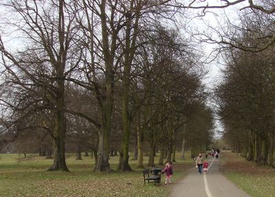
Cassiobury Park, Public park in Watford, England.

Cassiobury Park is a public park in Watford featuring open grounds with walking routes, sports facilities, and play areas with modern equipment. The space includes sections for resting and various recreational activities suited to different ages and interests.

The grounds were once part of a private estate belonging to the Earls of Essex until the early 1900s, when they were opened to the public. This transformation turned private land into a significant public space for the town.

The park serves as a gathering place where locals walk, play sports, and take part in celebrations year-round. Concerts and events here shape the rhythm of community life in the town.

The park is accessible by car with ample parking available and designated areas for those with mobility needs. The pathways are wide and level, making it easy to navigate for visitors of all abilities.

The park holds Grade II Listed status, recognizing its national importance as a historic garden and landscape. This designation protects both the garden design and any historic structures found within the grounds.

Location: Watford

GPS coordinates: 51.65970,-0.41667

Latest update: December 8, 2025 13:42

Photos
Around this place
Vicarage Road
United Kingdom

Vicarage Road

1.5 km
Cassiobury House
United Kingdom

Cassiobury House

610 m
Watford Palace Theatre
United Kingdom

Watford Palace Theatre

1.4 km
Church of St Mary, Watford
United Kingdom

Church of St Mary, Watford

1.5 km
Watford Town Hall
United Kingdom

Watford Town Hall

924 m
Holy Rood Church
United Kingdom

Holy Rood Church

1.4 km
Watford Peace Memorial
United Kingdom

Watford Peace Memorial

915 m
Beechen Grove Baptist Chapel
United Kingdom

Beechen Grove Baptist Chapel

1.4 km
Church of St Andrew
United Kingdom

Church of St Andrew

1.3 km
Clutterbuck Tomb 6 Metres South South East Of Deacon/Kent Tomb In Church Of St Mary
United Kingdom

Clutterbuck Tomb 6 Metres South South East Of Deacon/Kent Tomb In Church Of St Mary

1.6 km
Dalton/Guest Tomb 45 Metres South Of South West Corner Of Church Of St Mary
United Kingdom

Dalton/Guest Tomb 45 Metres South Of South West Corner Of Church Of St Mary

1.6 km
Tomb 5 Metres East Of Fawcett Tomb In St Mary's Church
United Kingdom

Tomb 5 Metres East Of Fawcett Tomb In St Mary's Church

1.6 km
Morison Tomb 10 Metres North Of The Mrs Elizabeth Fuller Free School In The Church Of St Mary
United Kingdom

Morison Tomb 10 Metres North Of The Mrs Elizabeth Fuller Free School In The Church Of St Mary

1.6 km
Headstone Of George Edward Doney Approx. 50 Metres Ssw Of The Tower Of The Church Of St Mary
United Kingdom

Headstone Of George Edward Doney Approx. 50 Metres Ssw Of The Tower Of The Church Of St Mary

1.5 km
Tomb 10 Metres South Of Chancel Of Church Of St Mary
United Kingdom

Tomb 10 Metres South Of Chancel Of Church Of St Mary

1.6 km
Watford Central Library
United Kingdom

Watford Central Library

940 m
14 And 16, The Parade
United Kingdom

14 And 16, The Parade

1.3 km
The Mrs Elizabeth Fuller Free School
United Kingdom

The Mrs Elizabeth Fuller Free School

1.6 km
Shipton/Finch Tomb 5 Metres East Of Chancel Of Church Of St Mary
United Kingdom

Shipton/Finch Tomb 5 Metres East Of Chancel Of Church Of St Mary

1.6 km
Benskin's House
United Kingdom

Benskin's House

1.4 km
Watford Place
United Kingdom

Watford Place

1.6 km
Fawcett Tomb 2 Metres South Of Chancel Of Church Of St Mary
United Kingdom

Fawcett Tomb 2 Metres South Of Chancel Of Church Of St Mary

1.6 km
Dundas Tomb 12 Metres South West Of Chancel Of St Mary's Church
United Kingdom

Dundas Tomb 12 Metres South West Of Chancel Of St Mary's Church

1.6 km
73 High Street
United Kingdom

73 High Street

1.5 km
Bedford And Essex Almshouses
United Kingdom

Bedford And Essex Almshouses

1.5 km
Cassio Bridge Lock Number 78
United Kingdom

Cassio Bridge Lock Number 78

963 m
Deacon Stracy Tomb 5 Metres East Of Dundas Tomb
United Kingdom

Deacon Stracy Tomb 5 Metres East Of Dundas Tomb

1.6 km
63 And 65 High Street
United Kingdom

63 And 65 High Street

1.5 km
Show the full map
Reviews

Visited this place? Tap the stars to rate it and share your experience / photos with the community! Try now! You can cancel it anytime.

« Cassiobury Park - Public park in Watford, England » is provided by Around Us (aroundus.com). Images and texts are derived from Wikimedia project under a Creative Commons license. You are allowed to copy, distribute, and modify copies of this page, under the conditions set by the license, as long as this note is clearly visible.

Discover hidden gems everywhere you go!

From secret cafés to breathtaking viewpoints, skip the crowded tourist spots and find places that match your style. Our app makes it easy with voice search, smart filtering, route optimization, and insider tips from travelers worldwide. Download now for the complete mobile experience.

Around Us App Screenshot

A unique approach to discovering new places

Le Figaro

All the places worth exploring

France Info

A tailor-made excursion in just a few clicks

20 Minutes