Vicarage Road

Log in to your account

AroundUs is a community-driven map of interesting places, built by curious explorers like you. It grows with every review, story, and photo you share.
Connect to save your favorite spots, contribute locations, and create personalized routes.
Continue with Google
Continue with Apple
Continue with X
Continue with Facebook
Continue with email
By continuing, you accept our Terms and Conditions and our Privacy Policy
Create an account

Vicarage Road

Add to collection
Map
Suggest a change
Share

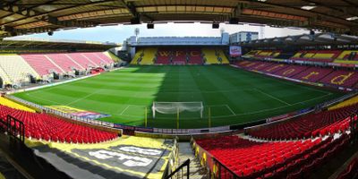
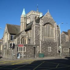
Vicarage Road, Football stadium in Watford, England

Vicarage Road is a football stadium in Watford, England, that holds around 22,000 spectators and has been in operation for over a century. The four stands each carry names that reference figures or areas from the club's past, and each section has its own character on match days.

The official opening took place in August 1922, when Colonel Charles Healey from the local brewery presided over the ceremony. The ground was rebuilt several times over the following decades to keep pace with the demands of modern football.

The stand received its name to honor the manager who led the club through its most successful period in the 1970s and 1980s. His influence shaped local football culture so deeply that supporters still speak of that era with pride.

The club shop sells merchandise and tickets, while several food and drink outlets open on match days. Some areas are accessible for wheelchair users, and arriving earlier helps avoid queues.

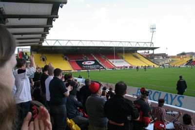
Between 1991 and 2013, two other sports clubs shared the ground with the football club at different times. The pitch hosted both rugby and football matches during those years, an uncommon arrangement for a stadium of this size.

Location: Watford

Inception: 1922

Official opening: August 30, 1922

Capacity: 22000

Website: https://watfordfc.com/matches/visiting-vicarage-road

GPS coordinates: 51.64993,-0.40161

Latest update: December 13, 2025 16:18

Photos
Around this place
Church of St Mary, Watford
United Kingdom

Church of St Mary, Watford

668 m
Holy Rood Church
United Kingdom

Holy Rood Church

581 m
United Kingdom

The Lairage Land

643 m
Dalton/Guest Tomb 45 Metres South Of South West Corner Of Church Of St Mary
United Kingdom

Dalton/Guest Tomb 45 Metres South Of South West Corner Of Church Of St Mary

600 m
Tomb 5 Metres East Of Fawcett Tomb In St Mary's Church
United Kingdom

Tomb 5 Metres East Of Fawcett Tomb In St Mary's Church

666 m
Clutterbuck Tomb 6 Metres South South East Of Deacon/Kent Tomb In Church Of St Mary
United Kingdom

Clutterbuck Tomb 6 Metres South South East Of Deacon/Kent Tomb In Church Of St Mary

587 m
Morison Tomb 10 Metres North Of The Mrs Elizabeth Fuller Free School In The Church Of St Mary
United Kingdom

Morison Tomb 10 Metres North Of The Mrs Elizabeth Fuller Free School In The Church Of St Mary

606 m
The One Crown Public House
United Kingdom

The One Crown Public House

711 m
Headstone Of George Edward Doney Approx. 50 Metres Ssw Of The Tower Of The Church Of St Mary
United Kingdom

Headstone Of George Edward Doney Approx. 50 Metres Ssw Of The Tower Of The Church Of St Mary

588 m
172, High Street
United Kingdom

172, High Street

732 m
174, High Street
United Kingdom

174, High Street

735 m
Tomb 10 Metres South Of Chancel Of Church Of St Mary
United Kingdom

Tomb 10 Metres South Of Chancel Of Church Of St Mary

652 m
The Mrs Elizabeth Fuller Free School
United Kingdom

The Mrs Elizabeth Fuller Free School

597 m
137, High Street
United Kingdom

137, High Street

735 m
Shipton/Finch Tomb 5 Metres East Of Chancel Of Church Of St Mary
United Kingdom

Shipton/Finch Tomb 5 Metres East Of Chancel Of Church Of St Mary

680 m
Watford Fields War Memorial
United Kingdom

Watford Fields War Memorial

559 m
Watford Place
United Kingdom

Watford Place

547 m
139, High Street
United Kingdom

139, High Street

736 m
Deacon Stracy Tomb 5 Metres East Of Dundas Tomb
United Kingdom

Deacon Stracy Tomb 5 Metres East Of Dundas Tomb

660 m
Fawcett Tomb 2 Metres South Of Chancel Of Church Of St Mary
United Kingdom

Fawcett Tomb 2 Metres South Of Chancel Of Church Of St Mary

657 m
Bedford And Essex Almshouses
United Kingdom

Bedford And Essex Almshouses

570 m
Dundas Tomb 12 Metres South West Of Chancel Of St Mary's Church
United Kingdom

Dundas Tomb 12 Metres South West Of Chancel Of St Mary's Church

655 m
73 High Street
United Kingdom

73 High Street

738 m
133 And 135, High Street
United Kingdom

133 And 135, High Street

733 m
160, High Street
United Kingdom

160, High Street

719 m
166 And 168, High Street
United Kingdom

166 And 168, High Street

724 m
158, High Street
United Kingdom

158, High Street

720 m
97, High Street
United Kingdom

97, High Street

717 m
Show the full map
Reviews

Visited this place? Tap the stars to rate it and share your experience / photos with the community! Try now! You can cancel it anytime.

« Vicarage Road - Football stadium in Watford, England » is provided by Around Us (aroundus.com). Images and texts are derived from Wikimedia project under a Creative Commons license. You are allowed to copy, distribute, and modify copies of this page, under the conditions set by the license, as long as this note is clearly visible.

Discover hidden gems everywhere you go!

From secret cafés to breathtaking viewpoints, skip the crowded tourist spots and find places that match your style. Our app makes it easy with voice search, smart filtering, route optimization, and insider tips from travelers worldwide. Download now for the complete mobile experience.

Around Us App Screenshot

A unique approach to discovering new places

Le Figaro

All the places worth exploring

France Info

A tailor-made excursion in just a few clicks

20 Minutes