Enable Location

We need your location to show you interesting places around you

Discover nearby places

Find interesting locations and hidden gems around you

Precise directions

Get accurate directions and distances to places

Your location is never shared with other users. It's only used when you tap the location button.

Croydon Flyover

Log in to your account

Start exploring — it's free

Trusted by 62,491 travelers worldwide

Continue with Google
Continue with Apple
or

We will send you a code to connect

By continuing, you accept our Terms and Conditions and our Privacy Policy

Check your inbox

We've sent a pincode in your inbox. Please enter the code below.

Croydon Flyover

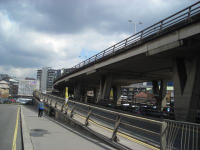
Croydon Flyover, Elevated road in London Borough of Croydon, England.

The Croydon Flyover is an elevated roadway that connects Park Lane to the Croydon Underpass via Duppas Hill Road, allowing traffic to pass above street level. The structure lets thousands of vehicles bypass ground-level intersections and traffic signals each day.

Built in 1964 during post-war expansion of London's road network, the structure was part of efforts to manage growing traffic flow across the city. Its construction reflected the era's focus on moving vehicles quickly through urban areas.

The elevated road structure offers views of Croydon landmarks, including the Fairfield Halls theatre and Centrale shopping centre from its vantage point.

The structure is visible from street level and is constantly in use, shaping traffic patterns throughout the area. Pedestrians can view it from various points in Croydon, though accessing the elevated level itself is reserved for vehicles only.

The original design included an under-road heating system intended to prevent ice formation, but it was never activated due to high maintenance costs. This hidden feature from the 1960s remains a curious remnant of experimental infrastructure thinking.

The community of curious travelers

AroundUs brings together thousands of curated places, local tips, and hidden gems, enriched daily by 60,000 contributors worldwide.

Start exploring
GPS coordinates
51.36930,-0.10330
Latest update
December 13, 2025 12:21
« Croydon Flyover - Elevated road in London Borough of Croydon, England » is provided by Around Us (aroundus.com). Images and texts are derived from Wikimedia project under a Creative Commons license. You are allowed to copy, distribute, and modify copies of this page, under the conditions set by the license, as long as this note is clearly visible.

Discover hidden gems everywhere you go!

From secret cafés to breathtaking viewpoints, skip the crowded tourist spots and find places that match your style. Our app makes it easy with voice search, smart filtering, route optimization, and insider tips from travelers worldwide. Download now for the complete mobile experience.

Around Us App Screenshot

A unique approach to discovering new places

Le Figaro

All the places worth exploring

France Info

A tailor-made excursion in just a few clicks

20 Minutes

Around Us
Travel Guide & Maps
Download

Send to your phone

QR Code
1

Open the camera app on your mobile.

2

Point at the QR code with your camera. A notification will appear.

3

Tap the notification to open the link.