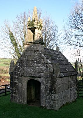
Dupath Well, Medieval holy well in Callington, England.
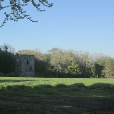
Dupath Well is a stone structure built over a natural spring with walls of local granite and a distinctive roof that slopes inward sharply. The building has decorative stone work at its corners and a small bell turret positioned above the entrance.
The structure was built around 1510 by Augustinian canons from St Germans Priory to tap a natural spring beneath the site. For centuries it provided fresh water to the surrounding communities and became an established part of the local landscape.
The spring became known as a place where people sought relief from ailments, especially respiratory troubles, believing in the healing qualities of its water. This reputation drew visitors across the region and made it an important stop on journeys seeking natural remedies.
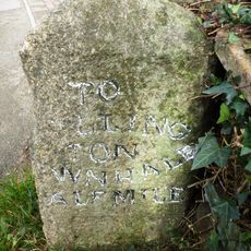
The site is open to visitors during daylight hours with parking available in the adjacent farmyard area. Good footwear is helpful when visiting as you walk across working farm areas to reach the well house.
Local legend speaks of two men who fought fatally near the well over romantic rivalry, a tale long remembered in the community. This story reflects the human dramas that unfolded around this water source across the centuries.
Location: Callington
Website: https://english-heritage.org.uk/visit/places/dupath-well
GPS coordinates: 50.49900,-4.28800
Latest update: December 14, 2025 11:00
Kit Hill Country Park
2.2 km
St. Mellion International Resort
3.3 km
Sylvia's Meadow
3.8 km
Church of St Mellanus
3.7 km
Church of St Dominica
2.4 km
St Mary's Church, Callington
2 km
Coryton Arms Excluding Extension On Left Hand Gable End
3.7 km
Milestone To East Of The Glebe
3.9 km
Callington War Memorial
2 km
Milestone, 100 Metres North Of Junction Of A390 With B3255
2.3 km
Milestone Ne Of Fullaford Crossroads (Ngr Sx3730670033)
1.1 km
Guide Post At South West Corner Of Cobbledicks Cottage
3.2 km
Milestone To The North Of No. 128
2.4 km
Guidestone At Sx 395 672
2.5 km
Milestone 250 Metres North West Of West Haye Farmhouse
3.3 km
Milestone At Viverdon Plantation
2.3 km
Milestone At North East Junctions Of A390 And Frogwell Road
3.2 km
Milestone At Sx 386708
1.9 km
Milestone At Sx 376 681
940 m
Milestone At Ngr Sx 3838 7132
2.3 km
Remains Of Engine House, Holmbush Mine
3.6 km
Borough Stone 10 Metres East Of Chyvarhas Residential Home
1.8 km
Milestone 400M South Of Rill Farm
2.1 km
Milestone On Hingston Down (Ngr Sx4021870943)
3 km
Milestone 300 Metres To South East Of Junction A388 With B3255
1.3 km
Buildings At Wheal St Vincent
886 m
Newbridge
3.3 km
Milestone, Westcott Lodge
925 mVisited this place? Tap the stars to rate it and share your experience / photos with the community! Try now! You can cancel it anytime.
Discover hidden gems everywhere you go!
From secret cafés to breathtaking viewpoints, skip the crowded tourist spots and find places that match your style. Our app makes it easy with voice search, smart filtering, route optimization, and insider tips from travelers worldwide. Download now for the complete mobile experience.
A unique approach to discovering new places❞
— Le Figaro
All the places worth exploring❞
— France Info
A tailor-made excursion in just a few clicks❞
— 20 Minutes