Dibbinsdale

Log in to your account

AroundUs is a community-driven map of interesting places, built by curious explorers like you. It grows with every review, story, and photo you share.
Connect to save your favorite spots, contribute locations, and create personalized routes.
Continue with Google
Continue with Apple
Continue with X
Continue with Facebook
Continue with email
By continuing, you accept our Terms and Conditions and our Privacy Policy
Create an account
Add to collection
Map
Suggest a change
Share

Dibbinsdale, Protected nature area in Merseyside, United Kingdom

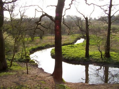
Dibbinsdale is a protected nature area in Merseyside featuring wetlands, woodlands, and grasslands within its boundaries. The reserve contains varied habitats that support numerous native plant and animal species across its landscape.

The area received protection status as a Site of Special Scientific Interest to conserve its natural ecosystems and native species. This designation ensures the landscape remains protected for future generations.

Local residents and visiting naturalists regularly use the paths to observe birds and insects throughout the seasons. The community gathers here especially during spring when apple blossoms appear across the woodland edges.

The reserve can be explored using marked walking paths that wind through different habitats and sections. Some areas close during certain seasons to protect sensitive wildlife, so visitors should check which routes are accessible before planning their visit.

The reserve holds ancient semi-natural woodlands and reed swamps with species specially adapted to wet conditions. These age-old woodland stands have been recognized as part of a network for woodland conservation.

GPS coordinates: 53.33100,-2.99500

Latest update: December 14, 2025 11:04

Photos
Around this place
Poulton Hall
United Kingdom

Poulton Hall

539 m
St Andrew's Church, Bebington
United Kingdom

St Andrew's Church, Bebington

2 km
St Barnabas' Church, Bromborough
United Kingdom

St Barnabas' Church, Bromborough

1.1 km
Dell Bridge, Port Sunlight
United Kingdom

Dell Bridge, Port Sunlight

2.1 km
Bromborough Golf Club
United Kingdom

Bromborough Golf Club

1.9 km
54, 56, 56A, Bromborough Village Road
United Kingdom

54, 56, 56A, Bromborough Village Road

1.2 km
Gladstone Theatre
United Kingdom

Gladstone Theatre

1.9 km
Sundial approx. 17m. to north of St. Barnabas' Church
United Kingdom

Sundial approx. 17m. to north of St. Barnabas' Church

1.1 km
Vineyard Farmhouse
United Kingdom

Vineyard Farmhouse

464 m
Barn at Vineyard Farm, Poulton Lancelyn
United Kingdom

Barn at Vineyard Farm, Poulton Lancelyn

487 m
Stanhope House
United Kingdom

Stanhope House

1.2 km
Wall to grounds of Stanhope House
United Kingdom

Wall to grounds of Stanhope House

1.2 km
Poulton Hey
United Kingdom

Poulton Hey

469 m
School and Masters House
United Kingdom

School and Masters House

1.1 km
2 and 4 Cross Lane, Bebington
United Kingdom

2 and 4 Cross Lane, Bebington

2.1 km
Mile Stone To South Of Junction With Mark Rake
United Kingdom

Mile Stone To South Of Junction With Mark Rake

1.2 km
Bromborough Market Cross
United Kingdom

Bromborough Market Cross

1.2 km
Bromborough WWII Memorial Plaque
United Kingdom

Bromborough WWII Memorial Plaque

1.1 km
Sundial approximately 13.5 metres to south of Church of St Andrew
United Kingdom

Sundial approximately 13.5 metres to south of Church of St Andrew

1.9 km
Lever House, Port Sunlight
United Kingdom

Lever House, Port Sunlight

1.9 km
Telephone kiosks at Port Sunlight Post Office
United Kingdom

Telephone kiosks at Port Sunlight Post Office

2.1 km
Bromborough WWI Memorial Tablet
United Kingdom

Bromborough WWI Memorial Tablet

1.1 km
Lancelyn farmhouse and attached barn
United Kingdom

Lancelyn farmhouse and attached barn

539 m
Brewhouse at Poulton Hall
United Kingdom

Brewhouse at Poulton Hall

497 m
Bebington War Memorial
United Kingdom

Bebington War Memorial

2 km
Bromborough War Memorial
United Kingdom

Bromborough War Memorial

1.1 km
Standing cross in churchyard of St Barnabas, Bromborough, beside the porch
United Kingdom

Standing cross in churchyard of St Barnabas, Bromborough, beside the porch

1.1 km
Milepost, Church Road; between Lynton Drive and Foxcovers Road
United Kingdom

Milepost, Church Road; between Lynton Drive and Foxcovers Road

1.5 km
Show the full map
Reviews

Visited this place? Tap the stars to rate it and share your experience / photos with the community! Try now! You can cancel it anytime.

« Dibbinsdale - Protected nature area in Merseyside, United Kingdom » is provided by Around Us (aroundus.com). Images and texts are derived from Wikimedia project under a Creative Commons license. You are allowed to copy, distribute, and modify copies of this page, under the conditions set by the license, as long as this note is clearly visible.

Discover hidden gems everywhere you go!

From secret cafés to breathtaking viewpoints, skip the crowded tourist spots and find places that match your style. Our app makes it easy with voice search, smart filtering, route optimization, and insider tips from travelers worldwide. Download now for the complete mobile experience.

Around Us App Screenshot

A unique approach to discovering new places

Le Figaro

All the places worth exploring

France Info

A tailor-made excursion in just a few clicks

20 Minutes