Enable Location

We need your location to show you interesting places around you

Discover nearby places

Find interesting locations and hidden gems around you

Precise directions

Get accurate directions and distances to places

Your location is never shared with other users. It's only used when you tap the location button.

Torhouse

Log in to your account

Start exploring — it's free

Trusted by 61,529 travelers worldwide

Continue with Google
Continue with Apple
or

We will send you a code to connect

By continuing, you accept our Terms and Conditions and our Privacy Policy

Check your inbox

We've sent a pincode in your inbox. Please enter the code below.

Torhouse

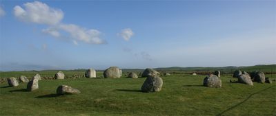
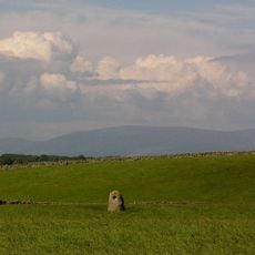
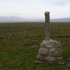
Torhouse, Bronze Age stone circle in Dumfries and Galloway, Scotland.

Description

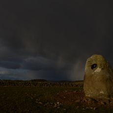
Torhouse is a Bronze Age stone circle made of nineteen granite boulders arranged about 60 feet (18 meters) across open grassland. The three central stones form a straight line rather than following the circular pattern of the other boulders.

History

This stone circle was built roughly 4000 years ago during the Bronze Age when such structures appeared across Scotland. The arrangement of stones reflects the skills and practices of these ancient people.

Culture

The three central stones align with solar movements and may have served ritualistic purposes for the people who built them. Such alignments suggest the site held meaning beyond simple gathering.

Practical

The site is accessible year-round and sits on open, flat grassland that can be windy. Visitors should come dressed for changing weather since the location offers no shelter.

Did you know?

The straight line of three central stones sets this site apart from typical round stone circles and suggests a different purpose. This unusual arrangement makes it stand out among Bronze Age monuments.

GPS coordinates
54.87750,-4.52264
Latest update
December 12, 2025 14:26

AroundUs brings together thousands of curated places, local tips, and hidden gems, enriched daily by 60,000 contributors worldwide. Discover all places nearby (Dumfries and Galloway).

Around this place
Baldoon Castle
United Kingdom

Baldoon Castle

5.2 km
Wigtown Town Hall (former Wigtown Sheriff Court)
United Kingdom

Wigtown Town Hall (former Wigtown Sheriff Court)

5.3 km
Newton Stewart, Dashwood Square, Mcmillan Hall
United Kingdom

Newton Stewart, Dashwood Square, Mcmillan Hall

9.1 km
Craighlaw
United Kingdom

Craighlaw

8.8 km
Hole Stone
United Kingdom

Hole Stone

1.9 km
Kirkcowan Parish Church, Church Of Scotland
United Kingdom

Kirkcowan Parish Church, Church Of Scotland

7.1 km
Old Place Of Mochrum
United Kingdom

Old Place Of Mochrum

7.8 km
Newton Stewart, Church Street, Penninghame Parish Church
United Kingdom

Newton Stewart, Church Street, Penninghame Parish Church

9.3 km
Covenanters' Monument
United Kingdom

Covenanters' Monument

5.6 km
Wigtown, Wigtown Parish Church
United Kingdom

Wigtown, Wigtown Parish Church

5.4 km
Sacred Heart Church
United Kingdom

Sacred Heart Church

5.3 km
Wigtown, Windy Hill, Covenanters' Monument And Enclosure
United Kingdom

Wigtown, Windy Hill, Covenanters' Monument And Enclosure

4.9 km
Old Prison House, Wigtown
United Kingdom

Old Prison House, Wigtown

5.4 km
Kirkinner, Main Street, St Kennera Church And Churchyard
United Kingdom

Kirkinner, Main Street, St Kennera Church And Churchyard

6.5 km
Wigtown, 9 Harbour Road, Manse
United Kingdom

Wigtown, 9 Harbour Road, Manse

5.4 km
Wigtown, Wigtown Parish Church, Churchyard, St Machute's Church
United Kingdom

Wigtown, Wigtown Parish Church, Churchyard, St Machute's Church

5.4 km
Newton Stewart, 77, 79 Victoria Street, Old Town Hall
United Kingdom

Newton Stewart, 77, 79 Victoria Street, Old Town Hall

9.5 km
Applegarth, Harbour Road, Wigtown
United Kingdom

Applegarth, Harbour Road, Wigtown

5.4 km
Shennanton, Old Bridge
United Kingdom

Shennanton, Old Bridge

7.7 km
Wigtown, The Square, Old Market Cross
United Kingdom

Wigtown, The Square, Old Market Cross

5.2 km
Gate Piers And Walls, Dunmore With Gates, Harbour Road, Wigtown
United Kingdom

Gate Piers And Walls, Dunmore With Gates, Harbour Road, Wigtown

5.5 km
Wigtown, The Square, New Market Cross
United Kingdom

Wigtown, The Square, New Market Cross

5.2 km
24 Bank Street, Wigtown
United Kingdom

24 Bank Street, Wigtown

5.4 km
Wigtown, 6 South Main Street
United Kingdom

Wigtown, 6 South Main Street

5.3 km
Wigtown, Church Lane, Wigtown Parish Church, Churchyard
United Kingdom

Wigtown, Church Lane, Wigtown Parish Church, Churchyard

5.4 km
White Cairn,cairn & Hole Stone 400m N of Crows
United Kingdom

White Cairn,cairn & Hole Stone 400m N of Crows

1.8 km
Wigtown, 19 Bank Street, Bank House
United Kingdom

Wigtown, 19 Bank Street, Bank House

5.4 km
Wigtown, 7 South Main Street, Old Custom House And Bank With Railings
United Kingdom

Wigtown, 7 South Main Street, Old Custom House And Bank With Railings

5.3 km
Show the full map
« Torhouse - Bronze Age stone circle in Dumfries and Galloway, Scotland » is provided by Around Us (aroundus.com). Images and texts are derived from Wikimedia project under a Creative Commons license. You are allowed to copy, distribute, and modify copies of this page, under the conditions set by the license, as long as this note is clearly visible.

Discover hidden gems everywhere you go!

From secret cafés to breathtaking viewpoints, skip the crowded tourist spots and find places that match your style. Our app makes it easy with voice search, smart filtering, route optimization, and insider tips from travelers worldwide. Download now for the complete mobile experience.

Around Us App Screenshot

A unique approach to discovering new places

Le Figaro

All the places worth exploring

France Info

A tailor-made excursion in just a few clicks

20 Minutes

Around Us
Travel Guide & Maps
Download

Send to your phone

QR Code
1

Open the camera app on your mobile.

2

Point at the QR code with your camera. A notification will appear.

3

Tap the notification to open the link.