Odsal Stadium, Rugby league stadium in Bradford, England
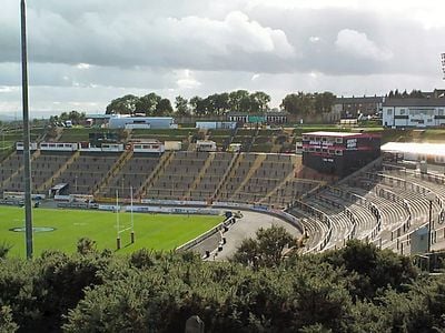
Odsal Stadium is a sports ground in Bradford, West Yorkshire, serving as home to rugby league matches and occasional stock car racing events. The seating area forms a deep concrete amphitheater carved into the hillside, offering uninterrupted sightlines across the playing field from most sections of the stands.
The ground opened in 1933 on land that had previously served as a municipal landfill and limestone quarry. More than 102,000 spectators gathered here in 1954 to watch a Challenge Cup Final replay, establishing a record for British rugby league attendance.
Local supporters refer to the ground by its location name, reflecting its connection to the surrounding industrial landscape that once shaped this part of West Yorkshire. Visitors arriving on match days share the terraces with fans who have followed the sport here across several generations, creating a community tradition rooted in working-class heritage.
Visitors reach the stadium through several entry points located around the outer perimeter, with the main gates positioned on the eastern and western sides of the site. The steep concrete steps between tiers require careful navigation, especially during wet weather when surfaces can become slippery.
The ground once held the title of the largest rugby league stadium in the world during the 1950s, though sections were later demolished to reduce capacity. The playing surface sits roughly 65 feet (20 meters) below the surrounding street level, making it one of the deepest sunken stadiums in British sport.
The community of curious travelers
AroundUs brings together thousands of curated places, local tips, and hidden gems, enriched daily by 60,000 contributors worldwide.