Enable Location

We need your location to show you interesting places around you

Discover nearby places

Find interesting locations and hidden gems around you

Precise directions

Get accurate directions and distances to places

Your location is never shared with other users. It's only used when you tap the location button.

St Mary's Island

Log in to your account

Start exploring — it's free

Trusted by 61,555 travelers worldwide

Continue with Google
Continue with Apple
or

We will send you a code to connect

By continuing, you accept our Terms and Conditions and our Privacy Policy

Check your inbox

We've sent a pincode in your inbox. Please enter the code below.

St Mary's Island

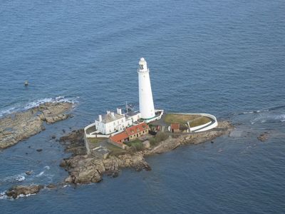
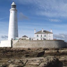
St Mary's Island, Tidal island with lighthouse in Tyne and Wear, England

Description

St Mary's Island is a tidal island off the coast of Tyne and Wear featuring a white lighthouse standing on sandstone cliffs. A rocky causeway links it to the mainland, becoming passable only when the tide retreats and exposes the rocky path.

History

The island once held a medieval chapel dedicated to Saint Helen, serving as a burial ground for monks and local residents. This sacred site was central to the spiritual life of the surrounding region.

Culture

Grey seals frequently gather on the outer rocks, making this location a notable observation point for marine wildlife along England's northeastern coast.

Practical

Check tide tables before attempting to cross the causeway, as the island becomes inaccessible during high tide. Wear sturdy shoes for safe footing on the slippery rocks.

Did you know?

The lighthouse building now houses an interactive museum where visitors can explore maritime objects in former keeper's cottages. These hands-on exhibits reveal the everyday life of those who once tended the light.

Location
GPS coordinates
55.07167,-1.44972
Latest update
December 10, 2025 16:21

AroundUs brings together thousands of curated places, local tips, and hidden gems, enriched daily by 60,000 contributors worldwide. Discover all places nearby (Tyne and Wear).

Around this place
Spanish City
United Kingdom

Spanish City

2.7 km
Seaton Delaval Hall
United Kingdom

Seaton Delaval Hall

3.2 km
St. Mary's Lighthouse
United Kingdom

St. Mary's Lighthouse

9 m
Playhouse, Whitley Bay
United Kingdom

Playhouse, Whitley Bay

2.8 km
Spanish City Theatre
United Kingdom

Spanish City Theatre

2.7 km
Chapel And Crematorium At Whitley Bay Cemetery
United Kingdom

Chapel And Crematorium At Whitley Bay Cemetery

1.1 km
Church of St Edward
United Kingdom

Church of St Edward

2.9 km
Church of Our Lady, Seaton Delaval
United Kingdom

Church of Our Lady, Seaton Delaval

3.2 km
Turntable Mechanism 20 Metres West Of The King's Arms Hotel
United Kingdom

Turntable Mechanism 20 Metres West Of The King's Arms Hotel

2 km
Ha Ha Wall With Angle Bastions And Statues Enclosing Seaton Delaval Hall And Church Of Our Lady
United Kingdom

Ha Ha Wall With Angle Bastions And Statues Enclosing Seaton Delaval Hall And Church Of Our Lady

3.2 km
Statue of Samson Slaying Philistine in Garden to West of Seaton Delaval Hall
United Kingdom

Statue of Samson Slaying Philistine in Garden to West of Seaton Delaval Hall

3.3 km
Mausoleum 500 Metres East Of Seaton Delaval Hall
United Kingdom

Mausoleum 500 Metres East Of Seaton Delaval Hall

2.7 km
The Delaval Arms
United Kingdom

The Delaval Arms

1.2 km
Obelisk 900 Metres South South West Of Seaton Delaval Hall
United Kingdom

Obelisk 900 Metres South South West Of Seaton Delaval Hall

2.6 km
War Memorial and Dwarf Walls, Steps and Piers Surrounding
United Kingdom

War Memorial and Dwarf Walls, Steps and Piers Surrounding

2.6 km
Sewer Gas Lamp
United Kingdom

Sewer Gas Lamp

2.7 km
Seaton Sluice and Old Hartley War Memorial
United Kingdom

Seaton Sluice and Old Hartley War Memorial

1.9 km
Kings Arms Hotel With Coach House To East
United Kingdom

Kings Arms Hotel With Coach House To East

2 km
Drinking Fountain
United Kingdom

Drinking Fountain

2.1 km
Privy 80 Metres North East Of Seaton Delaval Hall
United Kingdom

Privy 80 Metres North East Of Seaton Delaval Hall

3.2 km
Sewer Gas Lamp
United Kingdom

Sewer Gas Lamp

2.6 km
Drinking Fountain East Of Church Of St Paul
United Kingdom

Drinking Fountain East Of Church Of St Paul

3.3 km
Icehouse 100 Metres North East Of Seaton Delaval Hall
United Kingdom

Icehouse 100 Metres North East Of Seaton Delaval Hall

3.2 km
The Octagon
United Kingdom

The Octagon

2 km
Sewer Gas Lamp
United Kingdom

Sewer Gas Lamp

2.6 km
Outbuilding 60 Metres South West Of Fort House
United Kingdom

Outbuilding 60 Metres South West Of Fort House

1.2 km
Orangery In Walled Garden 300 Metres North East Of Seaton Delaval Hall
United Kingdom

Orangery In Walled Garden 300 Metres North East Of Seaton Delaval Hall

3.1 km
Milepost, Collywell Bay Road, Seaton Sluice
United Kingdom

Milepost, Collywell Bay Road, Seaton Sluice

1.5 km
Show the full map
« St Mary's Island - Tidal island with lighthouse in Tyne and Wear, England » is provided by Around Us (aroundus.com). Images and texts are derived from Wikimedia project under a Creative Commons license. You are allowed to copy, distribute, and modify copies of this page, under the conditions set by the license, as long as this note is clearly visible.

Discover hidden gems everywhere you go!

From secret cafés to breathtaking viewpoints, skip the crowded tourist spots and find places that match your style. Our app makes it easy with voice search, smart filtering, route optimization, and insider tips from travelers worldwide. Download now for the complete mobile experience.

Around Us App Screenshot

A unique approach to discovering new places

Le Figaro

All the places worth exploring

France Info

A tailor-made excursion in just a few clicks

20 Minutes

Around Us
Travel Guide & Maps
Download

Send to your phone

QR Code
1

Open the camera app on your mobile.

2

Point at the QR code with your camera. A notification will appear.

3

Tap the notification to open the link.