Donnington Bridge, Road bridge in Oxford, England
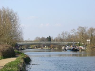
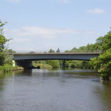
Donnington Bridge is a road bridge crossing the River Thames in Oxford, built from concrete and designed as a flat span that handles daily traffic between different parts of the city. The structure sits above the water on a series of supporting columns that form the bridge's main frame.
The bridge opened in 1962, replacing a ferry service that had connected the two parts of Oxford since the early 1900s. This marked a shift from water-based crossing to a modern road crossing for the area.
The bridge forms part of the B4495 road network and stands near the City of Oxford Rowing Club, connecting communities along the eastern bank.
The bridge is easily accessible from the main roads and provides a direct crossing for both pedestrians and vehicles between the two areas. Visitors should note that some bus services use alternative routes, which may be relevant when planning how to get around.
The external surfaces of the structure feature decorative stone cladding in contrasting colors, which sets it apart from typical gray concrete bridges. This attention to visual detail reflects design choices made in the 1960s to integrate the bridge into the city's character.
Inception: 1962
Official opening: 1962
GPS coordinates: 51.73556,-1.24208
Latest update: December 13, 2025 12:41
The Isis
972 m
River Cherwell
856 m
Iffley Lock
795 m
St Mary the Virgin, Iffley
947 m
St John the Evangelist Church, Oxford
1.2 km
University College Boathouse
898 m
Isis Bridge
1.2 km
Aston's Eyot
724 m
Oxfordshire and Buckinghamshire Light Infantry War Memorial
1 km
Church of Ss Edmund and Frideswide (Greyfriars Church)
942 m
Church of St John the Evangelist
971 m
Presbytery Of The Church Of St John The Evangelist
1.3 km
Roving Bridge Twenty Yards Upstream From Iffley Lock
629 m
Regal Cinema
1.3 km
16, James Street
1.2 km
Eastwyke Farmhouse
949 m
Stone In Abingdon Road Outside Number 309
581 m
New Hinksey Vicarage
1 km
Court House
906 m
Stone On The South West Side Of Rose Hill At The North East Corner Of Denton House Boundary Wall
952 m
Stone On Rose Hill Outside Number 37
1.2 km
2, Mill Lane
729 m
Rectory
918 m
Old Iffley Lock
744 m
Manor House
799 m
137, Iffley Road
1.1 km
Wall And Gate Of Townsend Close
593 m
Church Hall
871 mVisited this place? Tap the stars to rate it and share your experience / photos with the community! Try now! You can cancel it anytime.
Discover hidden gems everywhere you go!
From secret cafés to breathtaking viewpoints, skip the crowded tourist spots and find places that match your style. Our app makes it easy with voice search, smart filtering, route optimization, and insider tips from travelers worldwide. Download now for the complete mobile experience.
A unique approach to discovering new places❞
— Le Figaro
All the places worth exploring❞
— France Info
A tailor-made excursion in just a few clicks❞
— 20 Minutes