Chest opened
+${chestReward.xp} XP
Explorer
NOUVEAU ×${chestReward.collectible.quantity}
tapez pour fermer
Chest locked

Open chests in the app

Around Us is built for your phone — chests unlock when you walk, explore and capture nearby places.

Enable Location

We need your location to show you interesting places around you

Discover nearby places

Find interesting locations and hidden gems around you

Precise directions

Get accurate directions and distances to places

Your location is never shared with other users. It's only used when you tap the location button.

Log in to your account

Start exploring — it's free

Trusted by 73,096 travelers worldwide

Continue with Google
Continue with Apple
or

We will send you a code to connect

By continuing, you accept our Terms and Conditions and our Privacy Policy

Check your inbox

We've sent a pincode in your inbox. Please enter the code below.

Municipal Borough of Willesden
Discussion Reviews Photo
4.4k Popularity

Municipal Borough of Willesden, Former municipal borough in Middlesex, England

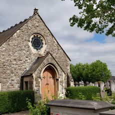
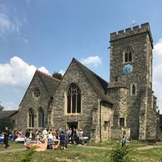
The Municipal Borough of Willesden was an administrative district in northwest London spanning approximately 1,900 hectares and encompassing several distinct neighbourhoods including Kilburn, Harlesden, Neasden, Dollis Hill, Cricklewood, and Brondesbury. Each area had its own character, with neighbourhoods showing different patterns of residential, commercial, and industrial development.

The area became a local government district in 1874, was upgraded to an urban district in 1894, and received formal municipal borough status in 1933. This gradual elevation of administrative rank reflected the area's rapid growth and rising importance during the industrial expansion of northwest London.

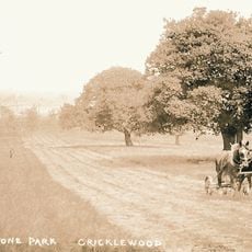
The name Willesden derives from Old English 'Wilstede', meaning settlement on a hill, reflecting its original geography. The area evolved from rural farmland into a diverse urban neighbourhood where communities from different backgrounds built their lives and raised families together.

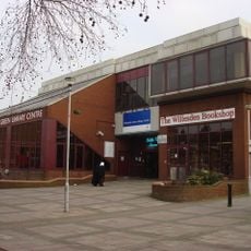
The administrative headquarters was originally located at Dyne Road in Kilburn and later developed into Willesden Town Hall, which served as the borough's centre. Visitors can explore the different neighbourhoods on foot today to see how each developed and changed over time.

The borough experienced explosive population growth between 1911 and 1931, fundamentally transforming its character and triggering rapid changes to its physical structure. This period of transformation made it a focal point of massive urbanisation during a crucial time of London's outward expansion.

The community of curious travelers

AroundUs brings together thousands of curated places, local tips, and hidden gems, enriched daily by 60,000 contributors worldwide.

Start exploring
Location
Inception
1874
Capital city
Willesden
GPS coordinates
51.54800,-0.24400
Latest update
March 6, 2026 16:53
Around this place
BAPS Shri Swaminarayan Mandir London
United Kingdom

BAPS Shri Swaminarayan Mandir London

1.2 km
Willesden Jewish Cemetery
United Kingdom

Willesden Jewish Cemetery

464 m
Gladstone Park
United Kingdom

Gladstone Park

1.2 km
Church of St Mary
United Kingdom

Church of St Mary

422 m
Willesden Green Library
United Kingdom

Willesden Green Library

1.1 km
Liberal Jewish Cemetery, Willesden
United Kingdom

Liberal Jewish Cemetery, Willesden

650 m
St Matthew's Church, Willesden
United Kingdom

St Matthew's Church, Willesden

775 m
Church of St Francis
United Kingdom

Church of St Francis

894 m
Church of St Andrew
United Kingdom

Church of St Andrew

863 m
United Kingdom

St Andrew's Church School

913 m
Memorial to Prisoners of War and Victims of Concentration Camps
United Kingdom

Memorial to Prisoners of War and Victims of Concentration Camps

1.3 km
Saint Michael and All Angels
United Kingdom

Saint Michael and All Angels

1.3 km
St Catherine's Church Neasden with St Paul
United Kingdom

St Catherine's Church Neasden with St Paul

1.2 km
United Kingdom

The Grange

1.2 km
United Kingdom

105,109 And 107, High Road Nw 10

980 m
United Kingdom

Brent Museum and Archives

1 km
United Kingdom

Willesden Liberal Jewish Cemetery War Memorial

637 m
United Kingdom

Premier Electric Theatre

904 m
United Kingdom

Tomb of Rosalind Franklin

244 m
United Kingdom

War Memorial, Willesden Jewish Cemetery

162 m
United Kingdom

Burial enclosures of Mayer, Juliana and Hannah Rothschild in Willesden Jewish Cemetery (United Synagogue Cemetery)

383 m
United Kingdom

Tomb of Max Eberstadt, Willesden Jewish Cemetery (United Synagogue Cemetery)

287 m
United Kingdom

Complex of Funerary Buildings at Willesden Jewish Cemetery (United Synagogue Cemetery)

235 m
United Kingdom

St Andrew's Vicarage

879 m
United Kingdom

Kingsley Court

1.1 km
United Kingdom

Sundisc

1.3 km
United Kingdom

"The Spirit of Youth"

892 m
United Kingdom

Scenic viewpoint

653 m
Show the full map
Reviews
Share your experience

No review yet

Discussions
Start a discussion...

No discussion yet

« Municipal Borough of Willesden - Former municipal borough in Middlesex, England » is provided by Around Us (aroundus.com). Images and texts are derived from Wikimedia project under a Creative Commons license. You are allowed to copy, distribute, and modify copies of this page, under the conditions set by the license, as long as this note is clearly visible.

Discover hidden gems everywhere you go!

From secret cafés to breathtaking viewpoints, skip the crowded tourist spots and find places that match your style. Our app makes it easy with voice search, smart filtering, route optimization, and insider tips from travelers worldwide. Download now for the complete mobile experience.

Around Us App Screenshot

A unique approach to discovering new places

Le Figaro

All the places worth exploring

France Info

A tailor-made excursion in just a few clicks

20 Minutes

Around Us
Travel Guide & Maps
Download

Send to your phone

QR Code
1

Open the camera app on your mobile.

2

Point at the QR code with your camera. A notification will appear.

3

Tap the notification to open the link.