Enable Location

We need your location to show you interesting places around you

Discover nearby places

Find interesting locations and hidden gems around you

Precise directions

Get accurate directions and distances to places

Your location is never shared with other users. It's only used when you tap the location button.

Plashett Park Wood

Log in to your account

Start exploring — it's free

Trusted by 63,074 travelers worldwide

Continue with Google
Continue with Apple
or

We will send you a code to connect

By continuing, you accept our Terms and Conditions and our Privacy Policy

Check your inbox

We've sent a pincode in your inbox. Please enter the code below.

Discussion Reviews 1 Photos
1.6k Popularity

Plashett Park Wood, Protected woodland near Isfield, East Sussex, England.

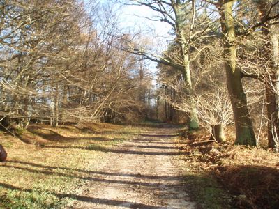
Plashett Park Wood is a woodland covering roughly 160 hectares between Lewes and Uckfield, crisscrossed by trails and featuring varied forest types. The site includes a teaching building with kitchen and classroom space, as well as a historic barn with a wood-burning stove available for visitors.

The woodland received protection as a Site of Special Scientific Interest in 1985, recognizing its ecological importance. This designation marked the beginning of formal conservation efforts to safeguard its natural character for future generations.

Forest School activities and outdoor learning programs operate here, with groups regularly coming to experience nature through hands-on activities. This educational role has become central to how the woodland is used and valued by local communities.

Wear sturdy footwear as the paths can become muddy, especially after rain. The teaching buildings and barn are available for groups, but advance booking is important to secure them.

The woodland supports around 67 breeding bird species and 25 butterfly species, including the pearl bordered fritillary and purple hairstreak. This rich wildlife makes it a rewarding place for nature watchers walking quietly through the forest.

The community of curious travelers

AroundUs brings together thousands of curated places, local tips, and hidden gems, enriched daily by 60,000 contributors worldwide.

Start exploring
GPS coordinates
50.92100,0.07800
Latest update
December 14, 2025 14:24
Around this place
Glyndebourne
United Kingdom

Glyndebourne

4.9 km
Bentley Wildfowl and Motor Museum
United Kingdom

Bentley Wildfowl and Motor Museum

2.4 km
Horsted Place
United Kingdom

Horsted Place

3 km
Laughton Place
United Kingdom

Laughton Place

4.7 km
Broyle Place
United Kingdom

Broyle Place

3.2 km
The Parish Church of St Margaret, Isfield
United Kingdom

The Parish Church of St Margaret, Isfield

3.1 km
The Parish Church of St Mary
United Kingdom

The Parish Church of St Mary

4.5 km
The Parish Church of St Mary the Virgin
United Kingdom

The Parish Church of St Mary the Virgin

3.4 km
The Parish Church of St Michael and All Angels
United Kingdom

The Parish Church of St Michael and All Angels

2.9 km
The Cock Inn
United Kingdom

The Cock Inn

2.9 km
Glyndebourne Opera House
United Kingdom

Glyndebourne Opera House

4.9 km
Barcombe War Memorial
United Kingdom

Barcombe War Memorial

4.5 km
Ringmer War Memorial
United Kingdom

Ringmer War Memorial

3.5 km
Isfield pound
United Kingdom

Isfield pound

3 km
Barn And Oasthouse To East Of Vuggles Farmhouse
United Kingdom

Barn And Oasthouse To East Of Vuggles Farmhouse

4.5 km
Cart Shed, Granary And Oasthouse To East Of Banks Farmhouse
United Kingdom

Cart Shed, Granary And Oasthouse To East Of Banks Farmhouse

3.1 km
The Beeches
United Kingdom

The Beeches

4.3 km
Bradness
United Kingdom

Bradness

4 km
Isfield Signal Box And Railway Level Crossing Gates
United Kingdom

Isfield Signal Box And Railway Level Crossing Gates

1.8 km
Home Farmhouse
United Kingdom

Home Farmhouse

4.4 km
Lichfield
United Kingdom

Lichfield

2.9 km
Virginia Lodge
United Kingdom

Virginia Lodge

4.6 km
Milepost, Uckfield Road, Upper Wellingham
United Kingdom

Milepost, Uckfield Road, Upper Wellingham

3.9 km
Milepost, jct with Isfield Road, N of the Old Ship PH
United Kingdom

Milepost, jct with Isfield Road, N of the Old Ship PH

1.1 km
Milepost, Eastbourne Road, between Timberley Gardens and Meadow View
United Kingdom

Milepost, Eastbourne Road, between Timberley Gardens and Meadow View

4.6 km
Milepost, between Crockstead Stables and Sand Hill Lane jct, by lane to farm
United Kingdom

Milepost, between Crockstead Stables and Sand Hill Lane jct, by lane to farm

3.8 km
Milepost, Ridgewood, Lewes Road, just S of jct with New Road
United Kingdom

Milepost, Ridgewood, Lewes Road, just S of jct with New Road

4.1 km
Milepost, High Cross Lake, road to Halland
United Kingdom

Milepost, High Cross Lake, road to Halland

4 km
Show the full map
Reviews
Share your experience

No review yet

Discussions
Start a discussion...

No discussion yet

« Plashett Park Wood - Protected woodland near Isfield, East Sussex, England » is provided by Around Us (aroundus.com). Images and texts are derived from Wikimedia project under a Creative Commons license. You are allowed to copy, distribute, and modify copies of this page, under the conditions set by the license, as long as this note is clearly visible.

Discover hidden gems everywhere you go!

From secret cafés to breathtaking viewpoints, skip the crowded tourist spots and find places that match your style. Our app makes it easy with voice search, smart filtering, route optimization, and insider tips from travelers worldwide. Download now for the complete mobile experience.

Around Us App Screenshot

A unique approach to discovering new places

Le Figaro

All the places worth exploring

France Info

A tailor-made excursion in just a few clicks

20 Minutes

Around Us
Travel Guide & Maps
Download

Send to your phone

QR Code
1

Open the camera app on your mobile.

2

Point at the QR code with your camera. A notification will appear.

3

Tap the notification to open the link.