Enable Location

We need your location to show you interesting places around you

Discover nearby places

Find interesting locations and hidden gems around you

Precise directions

Get accurate directions and distances to places

Your location is never shared with other users. It's only used when you tap the location button.

Shireoaks Hall

Log in to your account

Start exploring — it's free

Trusted by 62,834 travelers worldwide

Continue with Google
Continue with Apple
or

We will send you a code to connect

By continuing, you accept our Terms and Conditions and our Privacy Policy

Check your inbox

We've sent a pincode in your inbox. Please enter the code below.

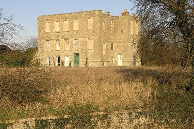
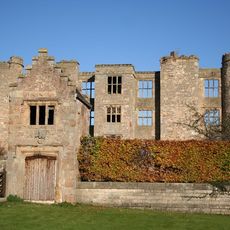
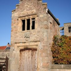
Shireoaks Hall, Grade II* listed house in Shireoaks, England.

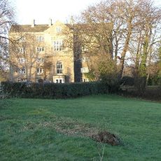
Shireoaks Hall is a house built with rough stone walls and a slate roof, set within a 40-acre park that shapes the visitor's first impression. The rectangular building sits within this large landscaped grounds, creating a country setting that feels removed from ordinary surroundings.

The house was built from 1612 to 1617 by John Smythson for Thomas Hewett. The stone came from Roche Abbey lands, obtained through merchants connected to the cloth trade in London.

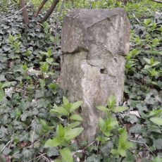
The place name refers to the oak trees that once marked the boundary between counties, a reference still visible in the trees scattered across the grounds today. This connection between the land and its name helps visitors understand how the area got its character.

The site is Grade II* listed, meaning the grounds and building are well maintained and preserved for visitors. Wear sturdy shoes as you walk through the parkland, since the ground changes with the seasons and can be uneven in places.

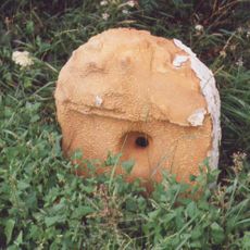
The house was built using stone from a nearby abbey whose ruins can still be visited today. This connection between the two places reveals how materials were reused in the early modern period.

The community of curious travelers

AroundUs brings together thousands of curated places, local tips, and hidden gems, enriched daily by 60,000 contributors worldwide.

Start exploring
Location
Inception
1617
GPS coordinates
53.31940,-1.17218
Latest update
December 12, 2025 12:01
Around this place
Worksop Manor
United Kingdom

Worksop Manor

3.1 km
Mr Straw's House
United Kingdom

Mr Straw's House

3.8 km
Lindrick Golf Club
United Kingdom

Lindrick Golf Club

2.1 km
St. John's Church, Worksop
United Kingdom

St. John's Church, Worksop

3.4 km
Worksop Town Hall
United Kingdom

Worksop Town Hall

3.8 km
St Luke's Church, Shireoaks
United Kingdom

St Luke's Church, Shireoaks

371 m
St. Anne's Church, Worksop
United Kingdom

St. Anne's Church, Worksop

3.2 km
Town Ground, Worksop
United Kingdom

Town Ground, Worksop

3.3 km
Worksop War Memorial
United Kingdom

Worksop War Memorial

3.9 km
Church of All Saints
United Kingdom

Church of All Saints

2.1 km
National Trust
United Kingdom

National Trust

3.8 km
Church of St Peter
United Kingdom

Church of St Peter

3.2 km
The Old Ship Inn
United Kingdom

The Old Ship Inn

3.7 km
The French Horn Hotel
United Kingdom

The French Horn Hotel

3.8 km
St Anne's War Memorial
United Kingdom

St Anne's War Memorial

3.2 km
Worksop East Signal Box
United Kingdom

Worksop East Signal Box

3.5 km
36 And 38, Carlton Road
United Kingdom

36 And 38, Carlton Road

3.6 km
Sundial Approximately 5 Metres To South East Of Porch To Church Of St Peter
United Kingdom

Sundial Approximately 5 Metres To South East Of Porch To Church Of St Peter

3.2 km
Shireoaks War Memorial
United Kingdom

Shireoaks War Memorial

350 m
Chesterfield Canal  Canal Milestone Immediately To West Of Milestone Lock
United Kingdom

Chesterfield Canal Canal Milestone Immediately To West Of Milestone Lock

1.7 km
Ruins Of Thorpe Salvin Hall
United Kingdom

Ruins Of Thorpe Salvin Hall

3.2 km
Chesterfield Canal  Canal Milestone Approximately 260 Metres To South East Of Devil's Hole Bridge
United Kingdom

Chesterfield Canal Canal Milestone Approximately 260 Metres To South East Of Devil's Hole Bridge

3 km
Former Worksop Central Library
United Kingdom

Former Worksop Central Library

3.9 km
Gatehouse To Thorpe Salvin Hall
United Kingdom

Gatehouse To Thorpe Salvin Hall

3.2 km
Milestone, Carlton Road; Gateford Hill, N of jct with Edison Park Avenue
United Kingdom

Milestone, Carlton Road; Gateford Hill, N of jct with Edison Park Avenue

3.5 km
Manor Lodge
United Kingdom

Manor Lodge

1.9 km
Milestone, between Worksop and South Anston
United Kingdom

Milestone, between Worksop and South Anston

2.2 km
Milestone, Mansfield Road; by No. 232, nr bridle path to Rhodesia
United Kingdom

Milestone, Mansfield Road; by No. 232, nr bridle path to Rhodesia

2.6 km
Show the full map
« Shireoaks Hall - Grade II* listed house in Shireoaks, England » is provided by Around Us (aroundus.com). Images and texts are derived from Wikimedia project under a Creative Commons license. You are allowed to copy, distribute, and modify copies of this page, under the conditions set by the license, as long as this note is clearly visible.

Discover hidden gems everywhere you go!

From secret cafés to breathtaking viewpoints, skip the crowded tourist spots and find places that match your style. Our app makes it easy with voice search, smart filtering, route optimization, and insider tips from travelers worldwide. Download now for the complete mobile experience.

Around Us App Screenshot

A unique approach to discovering new places

Le Figaro

All the places worth exploring

France Info

A tailor-made excursion in just a few clicks

20 Minutes

Around Us
Travel Guide & Maps
Download

Send to your phone

QR Code
1

Open the camera app on your mobile.

2

Point at the QR code with your camera. A notification will appear.

3

Tap the notification to open the link.