St Jude's Church, Mapperley

Log in to your account

AroundUs is a community-driven map of interesting places, built by curious explorers like you. It grows with every review, story, and photo you share.
Connect to save your favorite spots, contribute locations, and create personalized routes.
By continuing, you accept our Terms and Conditions and our Privacy Policy

St Jude's Church, Mapperley

Add to collection
Map
Suggest a change
Share

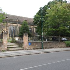
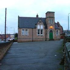
St Jude's Church, Mapperley, Anglican church in Mapperley, England

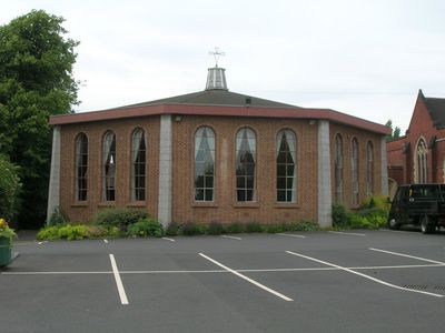
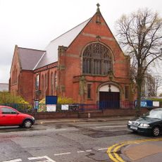
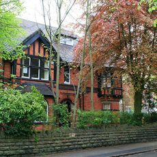
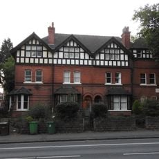
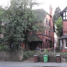
St Jude's Church is a Victorian building constructed from red brick and stone, positioned at the junction of Woodborough Road and Lucknow Drive with a prominent chancel that was added in 1893. The structure displays typical church architecture from that era, with its interior layout designed for traditional worship and community gatherings.

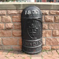
The church was established in 1877 as a daughter church of St Ann's to serve the expanding population of the Mapperley area. The addition of the chancel in 1893 reflected growing community needs and the church's role in the developing neighborhood.

The church serves as a gathering place for the local Mapperley community, where people come together for worship and social events throughout the year. Its halls and spaces host groups and activities that reflect the neighborhood's need for connection and shared purpose.

The church is best visited during service times when the building is open and the community spaces are accessible to guests. Online services and recorded broadcasts provide options for those unable to visit in person or who prefer to participate remotely.

Inside the church stands a pipe organ originally built by Conacher in 1898, which has undergone significant changes over the decades. The instrument received a complete restoration in 2002, making it a notable feature for music lovers visiting the church.

Location: Nottingham

Architects: Robert Evans JP

Website: http://stjudes-mapperley.org.uk

GPS coordinates: 52.97640,-1.13722

Latest update: December 14, 2025 16:43

Photos
Around this place
St Ann's Allotments
United Kingdom

St Ann's Allotments

940 m
Church of St. John the Evangelist, Carrington
United Kingdom

Church of St. John the Evangelist, Carrington

902 m
Mansfield Road Baptist Church
United Kingdom

Mansfield Road Baptist Church

1.6 km
Bagthorpe Gardens
United Kingdom

Bagthorpe Gardens

1.2 km
St. Ann with Emmanuel, Nottingham
United Kingdom

St. Ann with Emmanuel, Nottingham

1.5 km
Mapperley Methodist Church
United Kingdom

Mapperley Methodist Church

844 m
Miss Cullen’s Almshouses
United Kingdom

Miss Cullen’s Almshouses

839 m
Norris Almshouses
United Kingdom

Norris Almshouses

1.6 km
Sherwood Library
United Kingdom

Sherwood Library

756 m
Majestic Cinema
United Kingdom

Majestic Cinema

645 m
Boundary Mark On Island At Junction With Woodthorpe Drive
United Kingdom

Boundary Mark On Island At Junction With Woodthorpe Drive

1.2 km
Churchyard Wall, Railings And Gates To Church Of St John The Evangelist
United Kingdom

Churchyard Wall, Railings And Gates To Church Of St John The Evangelist

942 m
Clawson Lodge
United Kingdom

Clawson Lodge

863 m
Cleave House And Attached Boundary Wall
United Kingdom

Cleave House And Attached Boundary Wall

1.6 km
Malvern House And Attached Courtyard Wall
United Kingdom

Malvern House And Attached Courtyard Wall

1.2 km
Boundary Wall And Gateway To Numbers 409 And 411
United Kingdom

Boundary Wall And Gateway To Numbers 409 And 411

825 m
Woodthorpe Grange
United Kingdom

Woodthorpe Grange

1 km
Boundary Mark At Junction With Redcliffe Road
United Kingdom

Boundary Mark At Junction With Redcliffe Road

964 m
Boundary Wall And Gateway To Haydn Road Primary School Annexe
United Kingdom

Boundary Wall And Gateway To Haydn Road Primary School Annexe

962 m
413 To 419, Mansfield Road
United Kingdom

413 To 419, Mansfield Road

832 m
Boundary Wall To Number 30A Beech Wood
United Kingdom

Boundary Wall To Number 30A Beech Wood

1.1 km
Gateways And Boundary Wall To Numbers 413 To 419
United Kingdom

Gateways And Boundary Wall To Numbers 413 To 419

818 m
409 And 411, Mansfield Road
United Kingdom

409 And 411, Mansfield Road

842 m
Forest Lodge
United Kingdom

Forest Lodge

1.6 km
Garden Wall And Lych Gate To Clawson Lodge
United Kingdom

Garden Wall And Lych Gate To Clawson Lodge

852 m
Beech Wood
United Kingdom

Beech Wood

1 km
Haydn Road Primary School Annexe
United Kingdom

Haydn Road Primary School Annexe

934 m
Gate Piers And Boundary Wall To Malvern House
United Kingdom

Gate Piers And Boundary Wall To Malvern House

1.2 km
Show the full map
Reviews

Visited this place? Tap the stars to rate it and share your experience / photos with the community! Try now! You can cancel it anytime.

« St Jude's Church, Mapperley - Anglican church in Mapperley, England » is provided by Around Us (aroundus.com). Images and texts are derived from Wikimedia project under a Creative Commons license. You are allowed to copy, distribute, and modify copies of this page, under the conditions set by the license, as long as this note is clearly visible.

Discover hidden gems everywhere you go!

From secret cafés to breathtaking viewpoints, skip the crowded tourist spots and find places that match your style. Our app makes it easy with voice search, smart filtering, route optimization, and insider tips from travelers worldwide. Download now for the complete mobile experience.

Around Us App Screenshot

A unique approach to discovering new places

Le Figaro

All the places worth exploring

France Info

A tailor-made excursion in just a few clicks

20 Minutes