Enable Location

We need your location to show you interesting places around you

Discover nearby places

Find interesting locations and hidden gems around you

Precise directions

Get accurate directions and distances to places

Your location is never shared with other users. It's only used when you tap the location button.

St Mary's Church, Stainburn

Log in to your account

Start exploring — it's free

Trusted by 61,790 travelers worldwide

Continue with Google
Continue with Apple
or

We will send you a code to connect

By continuing, you accept our Terms and Conditions and our Privacy Policy

Check your inbox

We've sent a pincode in your inbox. Please enter the code below.

St Mary's Church, Stainburn

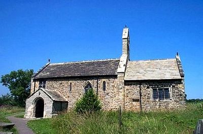
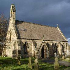
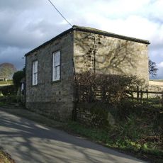
St Mary's Church, Stainburn, Norman church in Stainburn, England

Description

St Mary's Church is a church building in Stainburn featuring Norman and Gothic architecture. The structure consists of a three-bay nave with a southern porch, followed by a single-bay chancel with a vestry on the north side.

History

The building was erected in the early Norman period around 1101. Until 1975 it served as a chapel within the parish of Kirkby Overblow before coming under protection.

Culture

The interior displays strong Norman features such as a round carved font and arched chancel. Oak pews from the 17th century still shape the appearance today and speak to the long history of worship in this place.

Practical

The building lies about 6 miles southwest of Harrogate and is open to visitors daily. Be aware that wheelchair accessibility is limited and entry may be difficult for those with mobility challenges.

Did you know?

The building has been under the protection of the Churches Conservation Trust since 1977. This organization helps fund the ongoing maintenance and preserve the heritage.

Location
Inception
12 century
Architectural style
English Gothic architecture, Norman architecture
GPS coordinates
53.93250,-1.62460
Latest update
December 14, 2025 18:02

AroundUs brings together thousands of curated places, local tips, and hidden gems, enriched daily by 60,000 contributors worldwide. Discover all places nearby (Stainburn).

Around this place
Almscliffe Crag
United Kingdom

Almscliffe Crag

2.1 km
Arthington Viaduct
United Kingdom

Arthington Viaduct

3.4 km
Farnley Hall
United Kingdom

Farnley Hall

3.4 km
Church of St Oswald
United Kingdom

Church of St Oswald

2.2 km
Church of All Saints
United Kingdom

Church of All Saints

3.5 km
Leathley Bridge Over River Washburn
United Kingdom

Leathley Bridge Over River Washburn

2.7 km
Lindley Bridge Over River Washburn
United Kingdom

Lindley Bridge Over River Washburn

2.3 km
Pool Bridge
United Kingdom

Pool Bridge

3.1 km
Pool-in-Wharfedale War Memorial
United Kingdom

Pool-in-Wharfedale War Memorial

3.4 km
Milepost
United Kingdom

Milepost

2.1 km
Almshouses
United Kingdom

Almshouses

2.1 km
K6 Telephone Kiosk Near St Oswald's Church
United Kingdom

K6 Telephone Kiosk Near St Oswald's Church

2.1 km
Milepost At Se 235 454
United Kingdom

Milepost At Se 235 454

3.3 km
Stand-Pipe, Approximately 30 Metres South Of Almshouses
United Kingdom

Stand-Pipe, Approximately 30 Metres South Of Almshouses

2.2 km
Milepost At Junction With Stainburn Road
United Kingdom

Milepost At Junction With Stainburn Road

1.9 km
Milepost At Moorside Bridge
United Kingdom

Milepost At Moorside Bridge

1.4 km
Stocks Approximately 5 Metres North Of East Gate To Church
United Kingdom

Stocks Approximately 5 Metres North Of East Gate To Church

2.2 km
Milepost Approximately 120 Metres East Of Riffa House
United Kingdom

Milepost Approximately 120 Metres East Of Riffa House

2.5 km
Sign Post At Junction With Bradford To Harrogate Road
United Kingdom

Sign Post At Junction With Bradford To Harrogate Road

2.6 km
Milepost, Approximately 150 Metres North Of Huby Crossroads
United Kingdom

Milepost, Approximately 150 Metres North Of Huby Crossroads

2.9 km
Boundary Stone At Ngr 262 461
United Kingdom

Boundary Stone At Ngr 262 461

2.9 km
Milepost Opposite Entrance To Riffa Farm
United Kingdom

Milepost Opposite Entrance To Riffa Farm

2.3 km
Milepost Approximately 350 Metres West Of Junction With Harrogate Road
United Kingdom

Milepost Approximately 350 Metres West Of Junction With Harrogate Road

2.8 km
Milepost
United Kingdom

Milepost

1.3 km
Methodist Church And Retaining Wall With Gate And Steps
United Kingdom

Methodist Church And Retaining Wall With Gate And Steps

1.9 km
Milestone, Leathley Lane, Stainburn Bank
United Kingdom

Milestone, Leathley Lane, Stainburn Bank

1.2 km
Milestone, Wescoe Hill
United Kingdom

Milestone, Wescoe Hill

2.6 km
Milestone, NE of Otley. Pill White Lane
United Kingdom

Milestone, NE of Otley. Pill White Lane

1.8 km
Show the full map
« St Mary's Church, Stainburn - Norman church in Stainburn, England » is provided by Around Us (aroundus.com). Images and texts are derived from Wikimedia project under a Creative Commons license. You are allowed to copy, distribute, and modify copies of this page, under the conditions set by the license, as long as this note is clearly visible.

Discover hidden gems everywhere you go!

From secret cafés to breathtaking viewpoints, skip the crowded tourist spots and find places that match your style. Our app makes it easy with voice search, smart filtering, route optimization, and insider tips from travelers worldwide. Download now for the complete mobile experience.

Around Us App Screenshot

A unique approach to discovering new places

Le Figaro

All the places worth exploring

France Info

A tailor-made excursion in just a few clicks

20 Minutes

Around Us
Travel Guide & Maps
Download

Send to your phone

QR Code
1

Open the camera app on your mobile.

2

Point at the QR code with your camera. A notification will appear.

3

Tap the notification to open the link.